

July 7, 2007
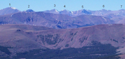
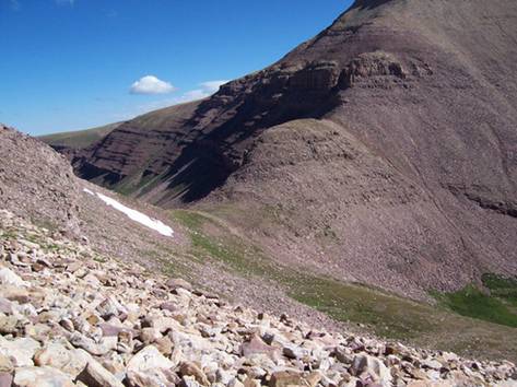
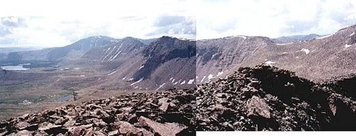
Seven summits in one day (Scott Patterson photo)
1 = Mount Emmons 2 = “North Emmons”
3 = “Roberts Peak” 4 = “Trail Rider Peak”
5 = “Painter Peak” 6 = South Kings Peak
7 = Kings Peak
The highest peak in
On Friday, as I was contemplating doing a long Saturday run, my thoughts drifted to the Uintas. A one-day summit of Kings Peak is a great run, about 28 miles. I’ve accomplished that run two times. I recalled an article I read in 2003 about two guys who accomplished a one-day “triple crown,” summiting the three highest peaks in Utah (Kings, South Kings, Gilbert) in one day using a base camp. One week later my brother-in-law and I tried to one-up that accomplishment by doing it all in one day from the trailhead. Our attempt was foiled. The night before, eight inches of snow fell on the peaks and we aborted the attempt after summiting Kings Peak.
So, I still had some unfinished business and I thought about doing a one-day “triple crown.” But as I considered it, now that I’m in ultrarunning shape, that seemed “too easy.” My warped mind started to consider more. How about the top four highest peaks? I checked the Internet and identified Mount Emmons as the 4th highest. However to get to that mountain from the others would be very tough. I would either need to take a very long indirect trail and come back after summiting, or even more difficult, reach the mountain from a long ridge (Kings-Emmons Ridge).
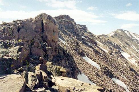
Kings-Emmons Ridge (Scott Patterson photo)
Left to right Emmons to Kings
The Kings-Emmons Ridge is the highest continuous ridge in
Usually the snow is still deep at this time of the year, but with a drought winter, I wondered if most of the snow would already be gone. I decided to play it by ear. I planned to first summit Kings Peak, evaluate the ridge, and if clear of snow, summit all the peaks on the ridge. My dream goal was to additionally summit Gilbert Peak and Gunsight Peak on the way back. If I did that, I could say that I accomplished the Utah Seven Summits (seven highest peaks) in one day. Wow, that would be cool.
I won’t delay the suspense. My adventure turned out to be a one-day, solo, self-supported round trip of the Kings-Emmons Ridge without a base camp. It was a 48-mile adventure. I believe I’m the only person to ever have done this. I hold to this belief because the shear distance of this would require ultrarunning fitness. It was a tough, grueling experience, tougher than I imagined.
I fully understood that this would be very risky. It is not a very smart thing to run/hike solo up high and in a very remote area of wilderness. I tried to take precautions by bringing emergency items (flint, knife, whistle, emergency blanket, jacket, first aid, and extra food.) Many people get lost in the Uintas every year. Sadly several are never found or their bodies are found a year later. A few years ago I was with a group of older scouts on a 50-mile hike in the Uintas. On the last morning, they needed to add five more miles to reach their 50-mile goal. I suggested we go do a trail run to a lake. All went well until one of the boys went ahead and took a wrong turn. He was lost for the next seven hours! I searched for him for 25 miles. He traveled ten miles and eventually ran in to some ATVers who helped him find his way to the rangers.
The Henrys Fork trailhead is about three hours from my home. Friday night I drove to the Fort Bridger area and checked into a motel hoping for three hours of rest. After midnight, I arose, made my preparations, and drove to the Henrys Fork trailhead. The parking lot was full of cars that certainly belonged to many backpackers camped up in Henrys Fork.
I started my adventure at 1:45 a.m. The temperature was comfortable and the early morning peaceful. I could hear the Henrys Fork River roaring down on my left, beside the trail. Directly ahead of me, I noticed Mars blazing in the sky. Behind my left shoulder, a half moon shone brightly, rising in the sky. It had been almost three years since I had run on this trail and it was before I was in ultrarunning shape. I immediately started to really enjoy the trail. The ascent was fairly gradual and the dirt surface was soft. The main challenge was the bowling-ball sized rocks imbedded all over the trail. In past years, those rocks really bothered me, but today I enjoyed the technical challenge that they presented.
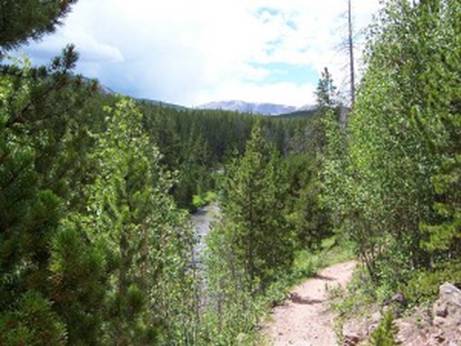
Daytime view of the forest trail along the river
I was able to keep a run going for most of the first six miles through the forest. I arrived at the Alligator Lake trail (mile 3) in 34 minutes. The cold breeze was causing me pain in my arms so I stopped to put on my long sleeves. I had an additional jacket wrapped around my waist just in case I had to stop where it was really cold. I reached the Elkhorn crossing (mile 6.5) at 1:27. I paused to take a picture of the bridge and river in the dark. (My greatest disappointment is that my old digital camera finally failed me. I lost all but one of the fifty pictures I took. So, all the pictures on this page have been borrowed/stolen from others.)
After crossing the river, the trail leaves the forest and winds through wide and open meadows. The temperature was noticeably warmer away from the forest. As I was running along to the music in my MP3, I was suddenly startled by loud and angry barking. I barked back, hoping to keep the beast away and shined my light in the direction of the noise. I saw a guy in a sleeping bag, sitting up, shielding his eyes from my light. “Oh, I’m sorry,” I said and continued on. Before reaching Dollar Lake, there is usually a marshy, muddy section that can be terrible. I was prepared. I brought some trash bags to put on my feet. However, I was greatly surprised to discover that the mud sections were not bad at all. I didn’t have to use the bags. Wow, the winter drought had drastically reduced the runoff. I arrived at Dollar Lake trail (about mile eight) at 2:05 (3:50 a.m.). I ran by some campers with tents under the trees.
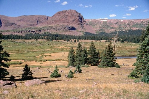
Daytime view near Dollar Lake.
From there, I was mostly above the tree line. I passed by several groups of tents and pushed a good pace up toward Gunsight Pass. On past runs up there, before my ultrarunning days, I would feel pretty wasted on the climb to the pass. This morning I felt great! Even though I’m four years older, it is much, much easier. As I was climbing, I noticed a flashlight flashing toward me from the base of the switchbacks.. I thought it might be hiker following after me toward Kings Peak, but it didn’t move. It must have been some early risers waking up at their campsite. I arrived at Gunsight Pass (mile 11.5) at 3:06 (4:41 a.m.).
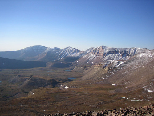
Daytime view looking back to Gunsight Pass from the cutoff route
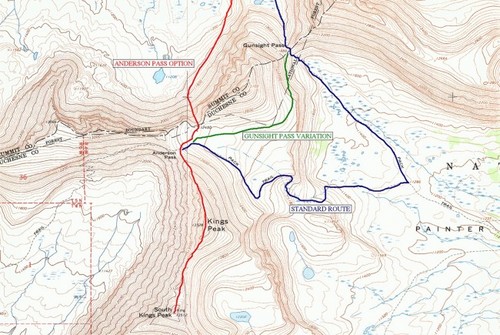
I took the cutoff route shown in green
The standard route into Painter Basin shown in blue
From Gunsight Pass, you can take two routes to Kings Peak. The official route drops down in Painter Basin and then climbs up to the basin below the mountain. A quicker route is to take a cutoff that climbs up to a plateau above some cliffs. That is the route I always take. With darkness, it was a little tricky and required a little route-finding, but I have been on the route ten times before so went on memory and ended up taking the quickest, easiest route. Once up on the plateau, the next goal is to find the Highline trail that runs across the basin. The dawn was arriving bringing a glow in the sky and waking up the birds that made their home in this high altitude basin. I watched the sun hit the top of Kings Peak at about 5:45 a.m.
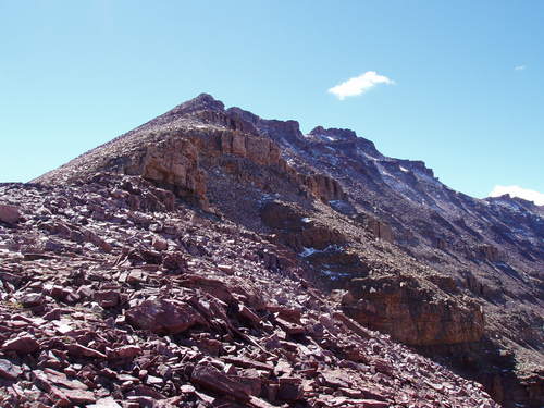
View from Anderson Pass looking up to Kings Peak
After reaching the Highline trail, I pushed ahead and arrived at 12,600-foot Anderson Pass (mile 13.5) at 4:14 (5:59 a.m.) I stopped to eat a yummy breakfast of peanut butter cups and instant breakfast. Next up was the steep climb of about a half mile and 1,000 feet vertical. In the past this stretch would kick my rear end, but this morning I felt strong as I climbed the boulders to the top. I could tell that my recent climbs up Mount Timpanogos had really helped me get used to altitude. The morning sun felt nice and warm and there was only a slight cold breeze. I arrived at the Kings Peak summit (13,528, mile 14) at 5:05 (6:50 a.m.). There I was standing, on the highest point of Utah. The views were amazing in all directions. The visibility was somewhat limited because of haze, probably from fires.
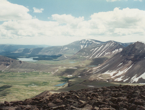
View from Kings Peak (Scott Patterson photo)
Looking down into Uinta River drainage including large Lake Attwood.
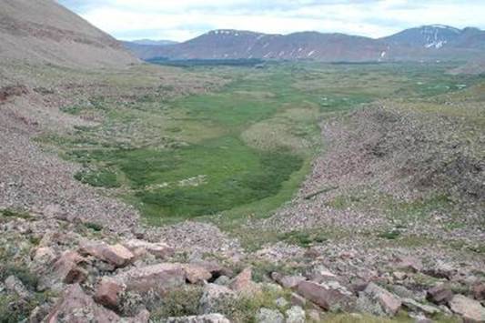
Kings-Emmons Ridge with Mount Emmons furthest away
For my adventure there was much less snow than seen here
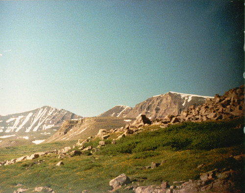
The biggest surprise was the lack of snow. There were only a few patches here and there. I looked southeast along the Kings Emmons Ridge and determined that the route was clear of any snow hazards. My decision was quick – I would press on along the ridge. My first destination would be South Kings Peak. Until the 1960s, this peak was thought to be the highpoint of Utah. In reality it is 16 feet lower. To get to it, I would need to descend down to a saddle losing about 400 feet of elevation and then make the climb up to the summit.
 <!
<!
Entire ridge as seen from Kings Peak
View of Kings Peak Summit (center)
Saddle and South Kings Peak (on right)
I arrived at South Kings Peak summit (13,512 feet, mile 15) at 5:46 (7:31 a.m.). I was pleased at how quickly I arrived at my second summit of the day. I was now standing on the second highest peak in Utah. I tried to call my wife, but was disappointed that I didn’t have a strong enough signal to make a call. That was bad news. I probably would not be able to call home all day. (I couldn’t). South Kings Peak was just like Kings Peak – a pile of boulders. There was no vegetation at all. Down on the saddles was scattered patches of grass and wildflowers, but on the steep slopes and summits, there was nothing but boulders. At the summit point was a little pile of rocks constructed by some hiker in the past. I also found a geocache.
I was still feeling strong but noticed a constant headache due to the altitude. It didn’t bother me 400 feet below, but at the summits it was a problem. I pushed on to my next destination, Painter Peak. One thing I quickly discovered was that the boulders were much more stable on the ridge line. Below the ridge, even if the route looked easier, the rocks were less stable and frequently moved when I would step up or down on them. My route was never a straight line – it was a constant zigzag picking my way through boulders finding good routes. It required intense concentration and most important of all balance. Wearing gloves was a must. At many points my hands would be needed to keep balance or help move up and down through the boulders. By the end of my adventure, my gloves were worn down to finger holes. Without them, my fingers would have been a bloody mess.
Water was a real challenge on the ridges. Up that high there were not springs or streams. Thankfully at this time of year there are still snow patches now and then. Usually on each peak I would pass a snow bank. To keep hydrated, I constantly added snow to my water bottle which would later melt. I also munched on snow balls. Without that source, I would have had to haul up a gallon or more of water. With this method I was able to stay well hydrated. I periodically added some Instant Breakfast to the bottle — yum, yum, Instant Breakfast slush. Because of the very low humidity, my mouth would become very dry with the constant hard breathing. I needed to sip often.
False summits were a constant disappointment all day. I would think that I was almost at the top of a peak only to discover that the true summit was still high and far away. I arrived at my next summit (13,306 feet) at 6:46 (8:31 a.m.) but discovered that this was not an official 13er on most lists because its saddle wasn’t low enough before the next peak, Painter Peak. The views were incredible looking down into the basins full of lakes and forests. I looked back toward Kings Peak and South Kings Peak. I was making good progress. Painter Basin down below was a beautiful sight to see. The streams reflecting the morning sun looked like silver strands weaving through a green background. I pushed down to the next saddle and quickly up to the summit of Painter Peak (13,387 feet). This is the 5th highest peak in Utah. I arrived there at 7:13 (8:58 a.m.).
When I arrived down on the next saddle, I said into my recorder, “Well, I’m down from both Painter Peaks. I’ve been on this ridge for 2.5 hours now. I’m feeling OK. The rock hopping is getting really old. At least down on these saddles there is real ground with flowers and moss. But up on those peaks there is nothing but a pile of rocks with a little moss on them. So, it is kind of hard to go fast. If I go fast on the rock hops, I hit wobbly rocks and end up bruising my feet so I have to back off and be careful. I am so far away from anybody, way out. It looks like these last few climbs are going to be the hairiest. The breeze is fine, the sun isn’t too hot. I want to get off this ridge before the afternoon storms start forming.”
Next up was Trail Rider Peak. The same routine, descend about 400 feet and climb back up. The boulders on the peaks varied at times. On some of the slopes the rocks were thinner and flatter. They tended to move and slide more and were more difficult to move over. But if I stayed closer to the ridge line, the rocks were more firmly in place. While climbing, I noticed a herd of mountain sheep or goats ahead of me. Wow, they were really up high. They noticed me too and went around the mountain slope before I caught up. I arrived at Trail Rider Peak (13,247 feet) at 7:52 (9:37 a.m.). It is the ninth highest peak in Utah. My headache continued to be a bother, but otherwise I was still feeling well at the top of Utah.
I gazed toward the next peak, Roberts Peak and didn’t like what I saw. The slopes were much steeper. I looked for a way to bypass this peak, but there was really no choice. The safest route was right up to the top and over. My descents were starting to become more painful. Hot spots were developing on the bottoms of my feet from shifting in the shoes. I tried to tighten up my laces and that seemed to help a little. The climb up Roberts was not as steep as it looked but it was much more difficult than the other peaks. Because the slope was steeper, the boulders were much less stable. It felt very risky and it became stressful. I again thought about the dangerous position I was in. With a mishap, I was on my own. The closest human was miles away and certainly would have great difficulty climbing up to where I was. There were several false summits to disappoint me, but I finally reached the pointy summit of Roberts Peak (13,287 feet, about mile 20) at 8:58 (10:43 a.m.). This is the sixth highest peak in Utah. I was now feeling thrashed. A bad blister had developed on the ball of my right foot. I had hoped to make my way across this ridge in five hours. So far it was four hours and Mount Emmons still looked to be far away. I knew that my dream goal of also summiting Gilbert and Gunsight was gone. I just wouldn’t have the strength or the time.
As I began to descend down the other side of peak, disaster struck. A rock I stepped on moved and I couldn’t catch my fall. With all those boulders, there is no way to fall nicely. My fall was pretty hard. Shins, knees, collar bone, and chin all hit rock. I was glad that the blow to my chin didn’t knock me out. I slowly picked myself up and examined my injuries. I had several bloody gashes on my legs and my collar bone was bruised pretty well, but I was intact. This spooked me somewhat. I just couldn’t risk any serious injury up this high so far away from a trailhead. I was even more cautious as I continued down slowly toward the next grass-covered saddle. I was very relived to arrive and ran a little toward my final two summits.
The climb up North Emmons was painful. The blister on my right foot was a real problem. Finally I came to a small trickle of water on a bare slope and I decided to stop to take a break and fix my foot. I taped the problem area and put on a clean sock. I also enjoyed some nice cold water instead of snow as I ate a HotPocket for lunch. After a nice rest I gathered my things together and pushed on up the mountain. I noticed that my right ankle was sore and soft because I had been trying to avoid the blister pain in my foot. My tape job helped and I now was able to walk on the foot properly. After an hour of so the ankle recovered. I didn’t realize that North Emmons qualified as a 13er, but it is 13,068 feet, the 16th highest Utah peak.
I gazed toward my last peak, Mount Emmons. It looked massive, but the slope I would have to climb didn’t look that steep. It would be a climb of nearly 1,000 feet. After descending about 500 feet, I made my way across the saddle and started my last major ascent. The wind was kicking up and I noticed that storm clouds were beginning to form. I didn’t want to be caught on this mountain during a thunderstorm, so that motivated me to push harder. Along the ridgeline there was a long stretch of snow bank. I enjoyed the change of climbing up a snow bank. It reminded me of the snow ridge at Squaw Peak 50, climbing up to Windy Pass. With the snow bank behind me, I was back to boulder hopping. I was sick of boulders. Soon I was nearing the rounded, summit. I made my way to the high point where some rocks were stacked. I arrived at Mount Emmons summit (13,440 feet, about mile 23) at about 1 p.m. Mount Emmons is the 4th highest peak in Utah. I didn’t stay long because of the storm clouds and wind.
I began descending to the east and contemplated what route would be best to get off this mountain. I had a clear view of my next destination back, Gunsight Pass, seven miles to the northwest. I could continue down the east ridge to link up with a trail 2.5 miles to the east, but I knew that would add many miles to my return. Instead I wanted to somehow get down the northern slope. At first I attempted a very direct route but my better judgment stopped me. It would be way to steep. I backtracked and continued at an angle toward the east. Looking down, I could see a series of slopes that would lead me to Carrot Lake. I longed to get on a nice grassy slope. I had had enough of boulder hopping. After several hours of this boulder madness, I finally noticed something very helpful. I noticed that the boulders that had moss stains on them were usually firm and didn’t move. This was because they had been in place for many years and hadn’t moved from the weight of the snow. The observation was very helpful as I descended down 2,500 feet. It was very long and hard but finally I reached some nice grassy slopes.
Everything was different at 11,000 feet. I saw birds, bugs, critters, bushes, flowers and even trees! I could feel a difference in my breathing. I was enjoying the experience after being at 13,000 feet or above for eight long hours. When I reached Carrot Lake, I filled my water bottles in the inlet stream and thoroughly enjoyed drinking the refreshing cold water. It was so pleasant and quiet. The lake was very beautiful. I looked up to the massive peaks I had been on and shook my head, wondering how I had done it. I had summited seven peaks over 13,000 feet.
Now my task was to return. There was no trail to use. As I had descended, I tried to plot a course that seemed to head me in the right direction. I now could actually run a little but it was painful. I pushed a pace up a forested slope north of the lake. It was amazing. This area is so remote that I doubt many humans had been there before. I could see no sign of human footprints anywhere. Since I had plenty of time before sundown, I took my time and enjoyed the hike through this wilderness. As I ran/hiked, I had a “Man vs. Wild” moment, the show on the Discovery Channel. It felt like I was in similar circumstances. I was left out in the middle of nowhere, with no trails to use and had to find my way out. I essentially knew where I was and what direction I needed to travel. But with each ridge I crested, I needed to figure out my next route.
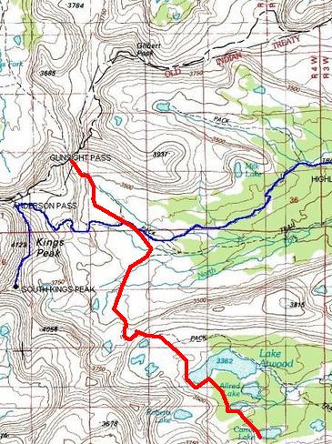
My route in red from Carrot Lake to Gunsight Pass
I reached Allen Lake and had to boulder hop again to get around it on the steep inlet slope. After cruising through more sparse forest, I reached a huge lake, Lake Attwood. I needed to head west in order to get around it. The Lake was a wonderful sight. I knew there was a trail somewhere to the north of it and my GPS helped me locate Trail Rider Pass. I remembered that the trail crossed over that pass. So I now knew where a trail could be located. Using my GPS I ascended several ridges and followed along some streams that flowed through meadows. After another short boulder hopping section, I saw a series of cairns! The trail led me to Trail Rider Pass (mile 29.5). This was the first trail I had seen in about ten hours. I was amazed at how much easier it was to run on a firm trail.
As I was running along, suddenly a very angry bird screamed at me and beat its wings on the ground in an attempt to scare me away. I looked up and noticed many little chicks walking around and chirping. I backed off from this angry mother bird and went around them, keeping my distance. I crested over a ridge and then the trail made a steep descent via switchbacks into Painter Basin.
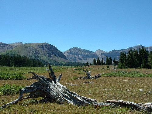
View from Painter Basin looking back toward (left to right)
I now could clearly see my next destination, Gunsight Pass still three miles away (as the crow flies). The trail I was on connected with a trail that would take me the wrong direction, so I decided to go cross country again. My route was a series of zig-zags as I made my way across drainages and tried to avoid sections of bushy foliage. It was slow going, but finally I linked up with the Kings Peak trail that headed up to Gunsight Pass.
View from Gunsight Pass looking back across Painter Basin to Mount Emmons
I arrived at Gunsight Pass (mile 34.5) at about 6:30 p.m. I was beat and my feet ached. I finally was back in “civilization.” The remaining trail through Henry Fork received plenty of human traffic every day. I stopped to feast on much of my remaining food. I looked up toward Gunsight Peak, originally in my dream plans to summit. It was a very steep but doable boulder scramble up. But no way today. I wanted to try to reach my car by sundown.
View looking across Henrys Fork Basin
It was now all downhill and I was able to again run freely. I had 11.5 more miles to go. I did my best to run, but I was entering the painful “death march” period when my body was ready to quit. I passed by a group of backpackers setting up their camps for the night in Henrys Fork Basin. The miles passed by slowly. I came upon three moose who watched me very carefully. Later I also came upon a deer buck with a nice rack on its head. I was able to come very close to him.
A couple brief rain storms blew in that felt refreshing. After crossing the river at Elkhorn Crossing, I was very anxious to get this adventure over. I pushed myself to keep the pace up. With about two miles to go I pulled out my flashlight. It was about 9:15 p.m. I was concerned that my wife would start worrying about me since she hadn’t heard from me all day. I did my best to keep my mind off my painful feet. Finally at 9:55 p.m., I arrived at the Henry Fork trailhead at 9,600 feet.
I had done it! It had taken about 20 hours and 48 miles, but I had summited seven 13ers in one day. It turned out to be a much tougher experience than I had ever imagined, but I was thrilled to have accomplished it. I did the hour-long drive to Lyman, Wyoming, called my wife and checked into a motel. Sleep came fast and I had nightmares about boulder hopping.
Totaly impressed Never been very athletic but I climbed Mt. Emmons on my 40th birthday in 1981 with my wife and 2 oldest sons. First snowball fight on my bithday (Aug. 1), and Kings peak with my 2 youngest sons when I was 50. I also visited Lake Atwood a couple times on horse back in my high school daze. I wondered if it was possible to go from one to the other the way you did. (But not in 1 day!)I could see the places you described in my memmory.
I bought your 3 books and enjoyed the daily accounts as you did the 150 years ago series. I just losded the 1847-50 files into word pad. I thought I remembered that they had a good wheat harvest in 48 dispite the cricketts and wondered if may bave been partly because of them. I had heard of other accounts of wheat producing a higher yeild after being eaten down.
Thanks for both items. Duane Hamblin
Roy, UT Formerly from Roosevelt
Pingback: » Utah Triple Crown Davy Crockett’s Running Frontier: I like to Run Insanely Long & Crazy Distances
Pingback: Double Kings Peak Adventure Run – 53 miles - Davy Crockett’s Running Frontier