

Even more fun than running 100-mile races for me is doing solo adventure runs. My first long solo adventure run was in 2002, to Kings Peak in Utah. Over the years I gained more and more experience and learned how run with minimal weight on my back, but enough food and emergency items to keep me out of trouble. I’ve now run thousands of miles solo in the back country in Utah and Arizona. I’ll routinely do runs of 50K to 50 miles and at times up to 100 miles.
I’ve been criticized as reckless for going out alone for such long distances. But those who know me understand that I’m actually pretty conservative as it comes to safety. I’m usually a broken record about safety in the Grand Canyon. The vast majority of my runs involve routes and trails where I know that I will run into somebody, so I’m rarely really alone. I know my limits and take what I think are reasonable precautions. On certain runs I’ll take a rented satellite phone or a SPOT tracker. Other things are taken like signal devices, fire starters, and emergency blankets.
Why solo? Well, first it is tough to find someone who can go as far and keep up. Second, in my mind with each person added to the adventure increases the odds that a problem will happen. I’m confident in my abilities and know that I can get myself out of most trouble. The biggest fear is an accident/fall which would leave me unable to walk out. But so far with thousands of adventure miles, things have worked out.
But precautions have to be made. I always inform others exactly where I am headed and when I plan to finish. If you announce an adventure publically, make sure those who learn about it know that you have everything taken care of. In 2013, a new friend announced a long difficult adventure in potentially bad weather and he let us follow online via his SPOT tracker. When terrible weather came in, the help button was pushed and none of us knew that this was actually a signal to his friend that he was bailing out to a pre-defined escape route. Those of us following were about to jump in our cars to the rescue and I stayed up almost all night worrying. All turned out OK, but the lesson learned was that we should not cause stress and worry on those at home. If we are clear with our plans and possible contingency plans, worry will be less and the right actions can be taken at the right time.
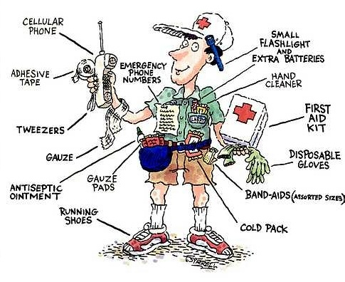
You need some good outdoor survival skills such as the ability to find water, start a fire, build a shelter, seek for food, read a map, and know directions by the sun and stars. Getting lost is way down on my list of worries because of careful preparation before the adventure. You need to stay on trails and routes, avoid short-cuts, and understand the dangers of getting rim rocked (stuck on ledges). You need be able to detect early both the symptoms of hypothermia and dehydration. If running at night, you need the right lighting systems and backups including batteries. You need great foot-care experience and bring with you items to repair your feet. You need solid first aid skills and some sort of kit. Without this experience and items I would never attempt these kinds of adventures.
Common sense tells me to avoid solo runs such as: Running in extreme conditions. I avoid heat, such as the Grand Canyon mid-May on. I avoid running in severe cold. I avoid running alone in the back country with snow avalanche danger. I avoid runs that require dangerous climbs. I’m not skilled in climbing and even if I were, I wouldn’t do that alone. I wouldn’t go into caves or mines or other such dangerous situations. I won’t run slot canyons if there are storm in the forecast. So no, I would never do the kinds of climbs and runs attempted by Aron Ralston. If I enter an area that looks dangerous, I’m not timid in turning around and going back. To me, those are just extra miles, no problem. Many people keep going because they dread going back because it seems hard. Not me.
So I hope as one reads about my adventures and if they are tempted to copy, that they have enough experience and are taking the right precautions.
Capitol Reef National Park
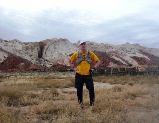
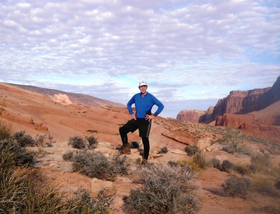
My favorite national park to run in is the Grand Canyon, and my second favorite is Capitol Reef National Park. This is one of the lesser known national parks. There is no entrance fee and when you drive through it on the highway, it only takes 15 miles to drive across its width. To me, it is a running treasure
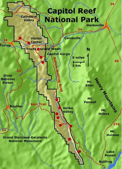
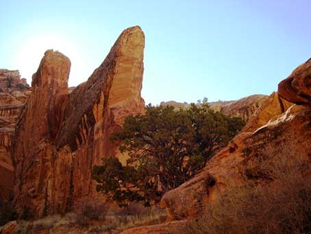
Capitol Reef is in a remote area of south-central Utah that did not have a paved road going to the area until 1962. In 1971 President Nixon signed a bill to make the area into a national park. This park is still a relatively secret national treasure compared to the other well-known parks in Utah. It is an ultrarunner’s paradise because of its solitude, spectacular scenery, primitive and rugged trails, slot canyons, and gorgeous slick rock.
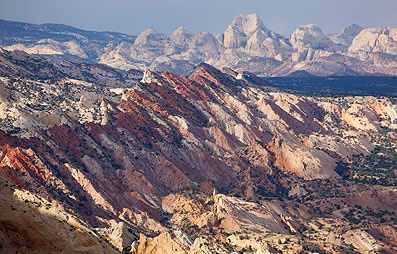
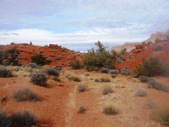
The major feature of the park is the Waterpocket Fold. This is a remarkable, nearly 100-mile long up-thrust extending like a rugged spine from Thousand Lake Plateau southward to Lake Powell. On the east side of the Waterpocket Fold is an extremely long valley that extends the length of the Waterpocket Fold.
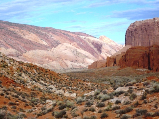
Bordering the east side of the valley are high cliffs of Halls Mesa. Winding through the valley is Halls Creek normally dry but runs full of water during flood run-off times. This valley can be brutally hot during the summer and surprisingly warm in the winter.
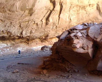
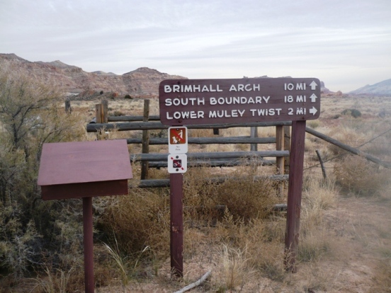
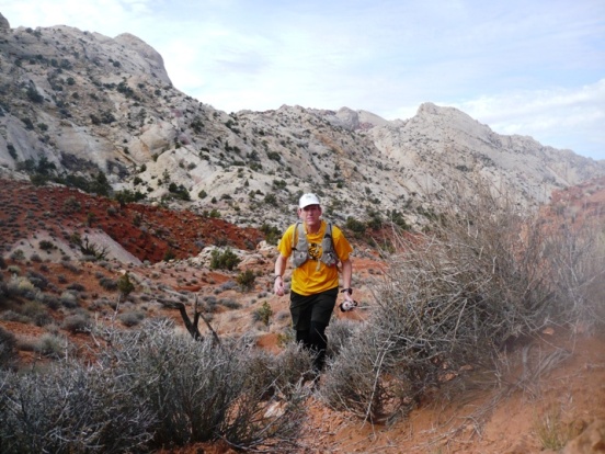
I’ve run about 150 miles in Capitol Reef National Park and have just scratched the surface of the many places to explore there. One of my favorite runs in the park is Lower Muley Twist. In the middle of the Water Pocket fold is a winding canyon that cuts its way for about twenty-five miles through the fold. This canyon received its name by the pioneers who came through the area. They said the canyon could twist up a mule train and thus was called Muley Twist.
As of 2014, I’ve run through Lower Muley Twist four times. There is also a route through Upper Muley Twist which gives you an opportunity to leave the canyon and run on top of the Water Pocket fold on the slickrock for several miles.
In 2002, in late November, before I discovered ultrarunning, I convinced backpacking buddies, Brad and David, to ditch their heavy boots for running shoes and go fast pack Lower Muley Twist with me. Brad and David were skeptical about this approach, fast packing, but came with me and we had a wonderful time exploring this canyon for the first time. It is almost as stunning as Paria Canyon, but the walls not as high.
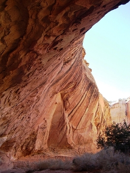
The colors are fantastic and the alcoves are amazing. For this adventure from the trailhead at “The Post” we first took a cutoff up and over the Water Pocket Fold and then descended into the Twist. From there we traveled down the canyon until it spilled out into the wide open Halls Canyon, which Halls Creek winds through. Using radios, we kept in contact with each other as Brad and David chose to hike in the creek bed and I ran up and down the old wagon trail exploring the desert.
David wrote, “For a while we followed Halls Creek which was meandering all over the valley until we finally struck out across on our own. We saw some fantastic scenery on both the drive down and the drive back on the Burr Trail was incredible including switchbacks up an almost sheer face followed by one of the most scenic canyons I’ve driven through in years, capped by the drive from Boulder to Torrey over the high plateau – beautiful!”
Just two weeks later I returned to run Lower Muley Twist again, this time in the opposite direction. It was December 7, but perfect weather to still run in shorts. This area can stay pretty warm and is great for winter runs. Only four other people had signed the register since David, Brad, and I had been there a couple weeks earlier. I took off running and heading south through Hall’s creek canyon was beautiful as the sun was rising.
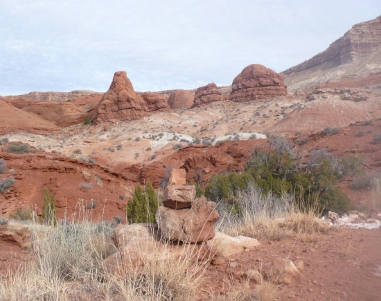
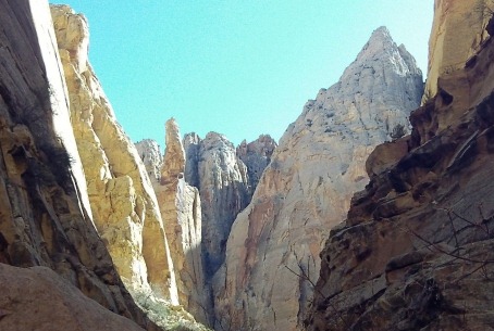
But then I became confused as to which canyon to turn into the Water Pocket Fold to reach Muley Twist. I chose what I thought was right but I only saw one set of foot prints. I continued on for more than an hour and eventually spilled back out into Halls Creek. I eventually noticed Brad and David’s footprints from two weeks earlier. It was a frustrating “turn” of events. I was determined to do it right and started over, still making a navigation blunder. I went a mile too far and reached Muley Tanks. I checked out the tanks. They were large pools, or tanks in the slick-rock, full of frozen water. Still determined, I headed north, bushwhacked, searching for the right canyon and found a very cool slot canyon on the way. But I eventually found the right canyon and had a great run up Lower Muley Twist. I learned my lesson and within a couple weeks I would buy my first GPS.
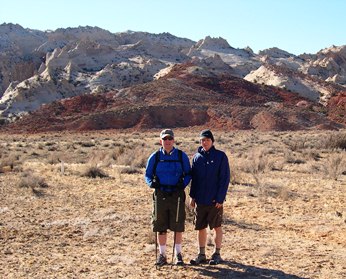
In 2004, I returned and ran the entire Lower Muley Twist with a neighbor friend. We did a big 22-mile loop and even climbed up the huge Burr Trail switchbacks to the top of the Fold.
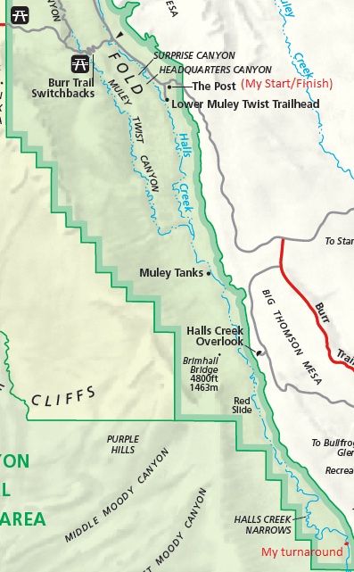
My favorite adventure in Capitol Reef was in December, 2010. This was a 42-mile out-and-back adventure run along the Hall Creek drainage, nearly all the way to the national park boundary near Lake Powell. I started at “The Post” at 2:30 a.m. and had an amazing night run in and along Halls Creek. No one else had signed to trailhead register for weeks so I was truly on my own, miles from anyone. I was basically trying to accomplish a five-day backpacking trip in about 12 hours.
I tried as much as possible to stay on the old wagon road that keeps a straight path down the valley, instead of following the winding river. The wagon road was developed in 1880s for access to Halls Crossing at the Colorado River. But the wagon road isn’t much of a road anymore. It now is a faint single-track trail depressed in the desert floor from the weight of years of wagons and horses. Now it even gets very little boot traffic because the area is so remote. I did notice plenty of coyote tracks on that trail and it looked like the coyotes were maintaining the trail more than hiker boots.
Soon I noticed water appearing in the creek. There would be long sections where a small amount would be flowing, but then it would disappear again for a few miles. At one wet spot, I made the mistake of running into quicksand. It sucked me into my shins. I would have wet feet for the rest of the run. What was funny is that on the way back, I again ran through this exact spot again.
A night obstacle illusion really boggled my mind. As I ran along the riverbed, it seemed like I was always running uphill. But I knew this was impossible because the creek flowed to Lake Powell. It really looked like and felt like I was running uphill. I even had to stop and look at the waterflow carefully to convince myself that I was actually running downhill. For the section I ran, the creek would actually lose nearly 1,000 feet.
The starry night was spectacular. At times I would turn out my light and just look up into the sky. I was so far away from any town or city so there was absolutely no light pollution. It seemed like I could see millions of stars. But then I saw a light up on the mesa. It looked like the moon was rising, but there was no moon. Finally I concluded that it must be some car headlights at Hall Creek Overlook. They turned out but later turned on again and were shining brightly down toward me. As I continued to run, I noticed that the light was now above the top of the mesa, floating in the sky! I was astounded to realize that I was looking at Venus rising. I couldn’t get over how bright it was here in the dark desert.
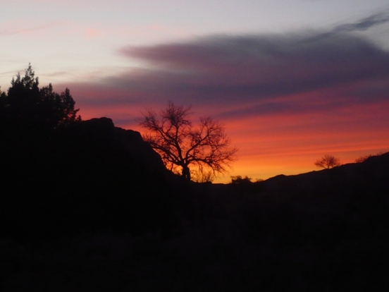
Finally I could see the glow of dawn appearing. I could tell that a spectacular sunrise was coming, so I climbed out of the creek and made my way to the Waterpocket Fold in order to climb up and get a better view. Climbing and running all over the white sandstone slickrock was a blast. I could see why they named this the Waterpocket Fold because there were plenty of pockets in the slickrock with puddles of water. The sunrise was spectacular. I had such an amazing feeling watching it, knowing that I was in such a remote location, and the only one there to see it.
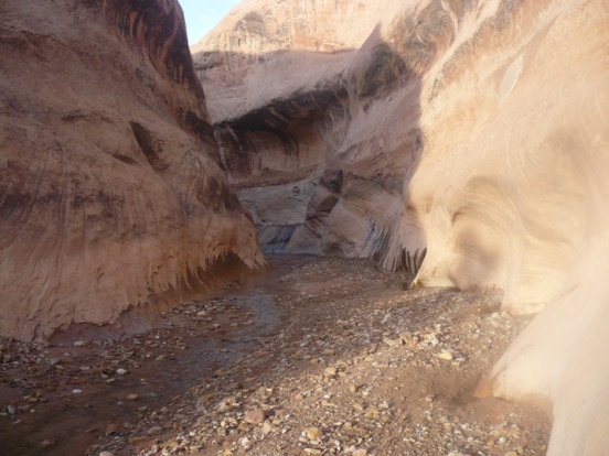
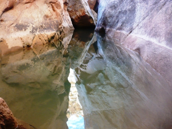
After the color show was over, I made my way down from the Waterpocket Fold and continued my run. I soon arrived at Halls Narrows. The creek started carving its way into the Waterpocket Fold making a spectacular three-mile winding slot canyon.
I knew continuing would involve wading and swimming, nothing I was interested in doing in December, so instead I headed up and over using the wagon trail to Halls Divide. Going up I couldn’t find the trail, but at the top I did and running down the other side was a complete blast.
At the other side of Halls Narrows, I did a little exploring inside the Narrows until deep water stopped me from going further. Back out, I looked at my watch. It was 8:45 a.m. time to turn back. I was very close to the park boundary and about six miles from Lake Powell. It would have been nice to make it to Lake Powell, but I had already run 21 miles. I could always return and try to go further.
Now with daylight, it was much easier to stay on the wagon trail. It was still pretty faint but I got very good in being able to relocate it. If I lost it, I would simple do a big zig-zag ahead and would always find it again because it just went straight.
My run back up the valley was spectacular with ever-changing colorful views. Finally my car came into sight and I finished my 42-mile run in about 12 hours, 20 minutes. It had been a perfect day. I love doing these adventure runs even more than running in the races. For me, this it running at its finest.
In 2013 I returned to Capitol Reef and for the first time ran both Lower and Upper Muley Twist. This video tell the story of this incredible run.
In 2014, I again traveled to Capital Reef National Park, only three hours from my home. I had always wanted to run Spring Canyon, which is a hidden deep and narrow canyon that runs west to east. It starts near Thousand Lakes Mountain and ends at the Fremont River. Towering above the canyon are Wingate cliffs and Navajo domes. The entire length of the canyon from the entry point above Sulphur Creek is about 18 miles. Add on to that about 5 miles to reach the entry point. In my case, I added on another seven miles for side trips and wrong turns for a rugged 30-mile adventure. It turned out to be an amazing all-day adventure. I was able to quickly hitch a ride back 13 miles to my starting point. This video tells the story.
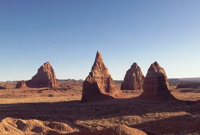
Cathedral Valley is a spectacular desert valley on the North end of the park that does not see many visitors because of the long dirt road access. I visited Lower Cathedral Valley containing the Temples of the Sun, Moon, and Stars. These spectacular monoliths are made of pink Entrada Sandstone. Before returning home, I did a quick seven-mile morning run around these remarkable monuments. With no trails, I did a random run up and down dry washes and across sandy desert mounds. This video tells the story