July 2-3, 2004
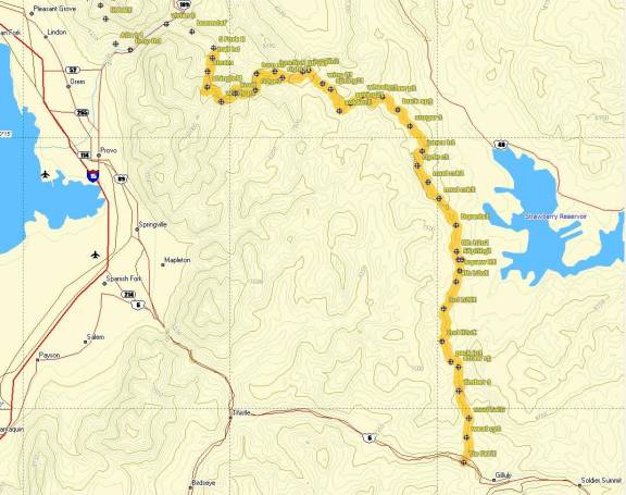
My goal was to hike from Spanish Fork Canyon to Brighton or Millcreek Canyon, along the Great Western Trail, in about 48 hours…at trip of about 100 miles. On Thursday afternoon, at 3 p.m., my wife, Linda, drove me to the trailhead in Spanish Fork Canyon, at Tie Fork, about eight miles west of Soldier Summit.
I brought with me a sheet of split times, to help me determine what my pace was. I also left a map on the fridge back home so I could call in my progress. I quickly discovered that it would be impossible to keep my pace goal because of the 17-pound pack on my back and the warmth of the afternoon. But I still kept up a good pace and traveled up the canyon along a dirt road. Also slowing me down was several unexpected stream crossings. I had to search for crossing points to avoid getting my feet wet.
I reached Strawberry Ridge (mile 7) by 5:30 p.m., traveling at a 3 mph pace. The last section was a pretty steep climb, but I kept it going and was greeted by a spectacular view looking toward the South. I stopped for my first short rest and then enjoyed some nice downhill sections winding through the hills toward the top of 2nd Water creek. Along the way I saw my only human for the day, a guy on a motorcycle who passed by. At 2nd Water creek, a herd of cattle gave me the stare-down as I prepared to continue.
The Great Western trail drops into the drainage of the water creeks, going up and down the ridges that separate them. I knew that would take too long and be pretty hard, so I choose to keep my route on the fairly level Strawberry Ridge where I could make some good time. I kept up a good 3.3 mph pace and called Linda when I reached Squaw Creek Road (mile15) where I had my first glimpse of Strawberry Reservoir, off to the east. I told Linda that it would be impossible for me to arrive at Vivan Park by noon. My pace was too slow. I told her I would call early in the morning before losing cell signal to give a new ETA. The plan was for Linda to bring a nice lunch/dinner and supplies for the second half of the journey.
At 5th Water, I located the spring designated on the map. I really needed to get water for the night and was disappointed that the spring was a seep, filling a muddy pool with thousands of foot-tracks from cattle. I found a spring source and did my best to obtain 3 liters of mostly clean water. In my quest to cut back on weight, I left my water filter home, so I would have to boil it.
The sun soon set and as I reached 6th Water (mile 16), a small thunderstorm approached and the wind blew in with force. I descended a road on the east, seeking shelter among the aspen trees, but the undergrowth was too thick. I decided to just stick it out by the road and put on my rain gear. A few strikes of lightning hit nearby, but the storm passed by quickly, only dropping a little rain that quickly dried up. I looked toward the southeast and saw a bright yellow-red light which I feared was a fire nearby started by a lightning strike. I considered my route for retreat as I climbed the road to get a closer look. I chuckled and I discovered the light was an amazing full moon rising at the horizon.
I had planned to make some dinner and move on, but I was frustrated to discover that the fuel bottle I purchased couldn’t be attached to the backpacking stove. Several times at home I told myself to test it out before going, but I never did. I considered my options and finally determined that I would build a fire. I quickly gathered some wood as the rainstorm passed over. My first quick attempt at starting a fire failed, but my second, more careful attempt, soon produced a nice fire by the side of the road in a ring of rocks.
As I was boiling the water, I was devastated to discover that a spark had jumped from the fire, landed on my water bladder, putting at least one hole in it. What else could go wrong! This was very discouraging. As I watched water leak from the bladder, I realized that I needed to hydrate myself and decided to go ahead, take my chances, and drink the precious water straight, before it leaked to the ground. I patched the hole and the leaking stopped. I prepared a dinner of rice which I tried to choke down. After awhile it tasted nasty and I gave up. A brew of hot chocolate hit the spot better. I bedded down and hoped that I would sleep at least a few hours.
At 1:30 a.m., I woke from a noise near the fire. I yelled, “Hey”, got up and saw a large skunk sniffing around my stuff. I did my best to coax it away and finally it crawled off into the brush. I knew I wouldn’t be able to get back to sleep, so I packed up and was almost ready to go by 2 a.m. As I was putting on my stuff, the skunk returned. I gathered up the rest of my stuff and went up the road a hundred feet or so. I was surprised to hear the skunk following me. I went further up the road and the same thing happened. I had had enough of that skunk so I went all the way to the top of the ridge and soon was on my way. I quickly ran into another skunk and moved on away fast from that area.
The full moon was spectacular, presenting a nice night-view of the trails. The moon set, just as the sun was rising when I reached Clyde Creek Road (mile 23). I had only traveled six miles during the darkness, a pretty slow pace. I called Linda and told her my new prediction was for a 4-5 p.m. arrival at Vivian Park. With the light of the sun, I picked up my pace and reached Buck Spring (mile 28) at 8:00 a.m. Buck Spring is a nice clean spring. I rested for 45 minutes, did some blister prevention, made sure I was fully hydrated, and ate a scrumptious breakfast of Cliff Bars. Three ATVs drove by, only the second of three encounters with humans during this trip.
My brother Bob called my cell phone as I approached Strawberry Peak, but the coverage was spotty. I saw plenty of wildlife on this hike including 6-7 deer, 2 moose, several pheasants, plenty of hedge hogs, and of course skunk. At 10 a.m., I reached another nice spring that fed into a bath tub. I fully hydrated again. I reached Soldier Bench (mile 34) at 10:30 a.m., after a nice, long down-hill stretch, losing about 1500 feet. I knew that I would next have my first long uphill stretch toward Wing Flat. I cruised up this section OK and at the 36-mile mark, ran into a couple ATVers who stopped and asked me where I was coming from. I explained where I had started and the couple was shocked and impressed to hear that I had come from Spanish Fork Canyon. They were further shocked to hear that my goal was Brighton by tomorrow evening. They bid goodbye and about 15 minutes later a second group came by. They too stopped and asked if I was the guy heading to Brighton. They asked me several questions, wondering why I was doing it, how fast my pace was, and wished me luck.
I gave back over 1000 feet during a long down-hill stretch heading toward Little Valley. The heat of the day was becoming intense. At noon, I reached Little Valley (mile 40). I found a good stream, quickly searched for shade, and made a lunch stop. My legs were starting to revolt after that downhill stretch, but I still felt fine. I look forward, and was discouraged to see that the only way out of the valley to the west was to go up and over a high, steep ridge. I made sure my camelback was as full as possible without leaking and I ate almost all of my remaining food, thinking that I was only five hours from a nice feast at Vivian Park. Little did I know!
After this nice rest, I headed west, and traveled up the Right Fork of Little Hobble Creek. The Great Western trail became a single-track trail that I thought was a nice change from the roads. The trail became a grueling, steep up-hill grind and my pace slowed because of the heat of the day. I finally reached the top of a ridge, but was discouraged to see that the trail still headed upward. I called Linda and adjust my ETA again to 5:30.
From there, things became terrible. The condition of the trail became horrible. I’m sure few people used this trail because of its remoteness. The bushes stuck out into the trail and no trail work had been performed to remove rocks from the trail. It became impossible to keep up a good pace, and I was forced to slow down to less than 2 mph. I made a giant circle around Bald Knoll, which gave me a great view of my goal down to a ranch at the South Fork of the Provo River. I considered bypassing the climb up to Windy Pass, which would save me a couple hours, but never found a trail heading down. I dismissed the idea of bushwhacking and pressed on.
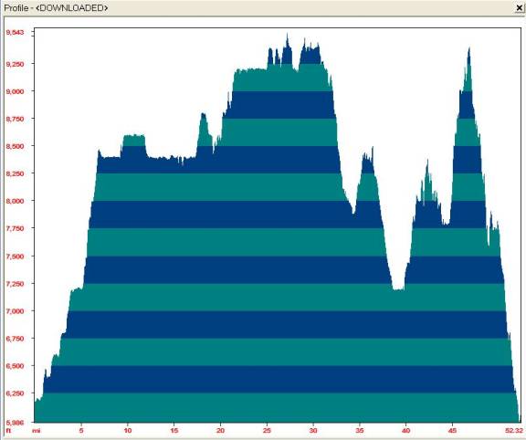
I thought things would get better as I reached at the 44-mile mark. But it got worse. I looked ahead and realized the way ahead would take me up a massive, steep 1,500 foot slope. I called Linda again and adjusted my arrival time to 6:30. The trail condition became worse. I trudged up the trail at a discouraging slow pace. My body had burned all the food eaten at Little Valley and I knew I had no more. My pain-killers wore off and I didn’t want to take the time to remove my pack and get more. The heat, at 8,500 feet was surprisingly hot. In short, my body started to give up. The pain became intense, and my leg function started to shut down. As I was trudging up that grueling stretch, I realized that my arrival time would be even later, and for the first time I considered aborting at Vivian Park. Soon I concluded that would be my only choice. I called Linda again, and told her I wouldn’t arrive before 7 p.m., and hinted that I would probably be coming home.
I reached Windy Pass (mile 47), at about 5 p.m., next faced with a massive 3,300-foot descent to the South Fork. The descent caused terrible pain in my knees, but I still was able to kick it in and do some stretches of running. My legs also started to sting because of frequent brushes against stinging nettles. The trail never improved, a poorly maintained route that obviously attracted few hikers. At 6 p.m., I called Linda again and asked her to meet me at the trailhead of South Fork, which would avoid a 5-mile road-stomp to Vivian Park.
At 7:30 p.m., I arrived at the trailhead, the 53-mile mark, with Linda waiting. The pain was very intense in my feet and knees, but it felt great to sit down for my first long rest since noon. After downing a Subway sub, my body started to recover. I called Bob, told him I had aborted, and clearly felt that I would never attempt that hike again. He was lucky he had cancelled.
I hated to abort and miss the second day of the hike, but I knew that the Windy Pass section had killed me. I had miscalculated the distance through that section by several miles and didn’t foresee the steep climbs and terrible trail conditions. I lost 8 pounds during the hike and slept well that night despite the pain.
In the morning, I felt great, almost sorry that I aborted, just a little knee soreness. The foot pain was gone. How soon one forgets pain! I was surprised to discover my hike included 12,000 of uphill hiking. I looked at the maps and considered that a more direct route clear to Brighton would have been “simple” if I would have taken a more direct route suggested by Bob. By cutting over to Wallsburg from Little Valley, bypassing Timp, and going up Provo Deer Creek, I would cut off 25 miles and probably 15 hours. Also, cooler weather would really make a difference. Some day I will try again! The Great Western Trail wasn’t very great.

