

North Kaibab to Boucher Creek and back
November 23-24, 2007
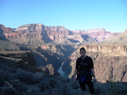
I had another spectacular run in the Grand Canyon on Thanksgiving weekend. Last year, I ran an 87-mile double-crossing to Hermit’s Rest and back from the North Rim. This year I planned to do a similar run but with the difference being a climb up the rugged Boucher Trail to the South Rim. I didn’t quite reach that goal, skipping the tough climb up the South Rim, but I did have an amazing adventure running on the West Tonto Trail, running all the way to Boucher Creek from the North Rim and back, over 78 miles. I ran 40 miles on the remote West Tonto Trail.
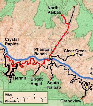
My actual route in red
This run included an exciting twist to it. When I went to rent a Satellite phone from Skycall, Russ Smith offered me a discount and the use of a Spot Satellite Messenger if I agreed to call in to the KSL Radio Utah Outdoor show on Saturday morning. This sounded like great fun. In preparation, I gave my backpacking and running buddies the information to log into a website, to track my progress on Google Satellite Maps. I also invited anyone on the ultra list (email discussion list) to subscribe to a listserv that would distribute emails with my location. They could click on a link to see where I was. About 30 signed up to watch me. My backpacking buddy Carl helped me set this up. This would be eerie, to be in the remote wilderness with many people watching me from the skies! I also gave my backpacking buddies an address for them to email me rude text message along the way, which I could read on the Satellite phone.
Yes, I was going to be a true techno-nerd Grand Canyon runner! I would take: Satellite phone (Iridium 9505A), Spot Satellite Messenger, GPS, audio recorder, camera, mp3 player, and flashlights. Hmm…that is a total of 16 batteries, and about six more spares! Could I get any nerdier? I should have brought a pocket protector.
After a wonderful Thanksgiving dinner with my family, I hit the road. The toughest thing about the drive was avoiding all of the deer in the road along the way. I counted six standing in the road. At one point, there seemed to be so many around that I would toot my car horn constantly for several miles in hopes to alert deer ahead. The moon was nearly full and I was excited to have it as a companion during my run. Snow flurries started as I neared the National Park. I arrived at the North Kaibab trailhead at about 12:15 a.m.
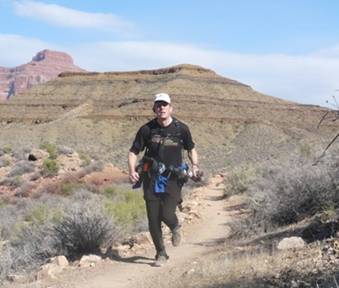
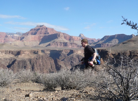
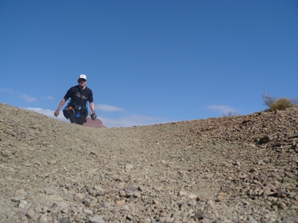
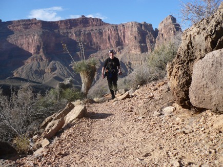
Ready to go. Without backpack?
I tried my best to snooze, but at 1:00 a.m. gave up and started to get ready. At 2:00 a.m., I tuned on the Spot Satellite Messenger and strapped on my gear. I would hang most my electronics junk off a waist belt, and stuffed a camelback with food and all my usual gear. For this run I would bring warm clothes because the average temperature would be in the 40s in the canyon with frigid teen temperatures at the rims. I took a quick picture at the trailhead and then started down the canyon. Within 100 feet, I realized something was wrong. I had forgotten my pack. Wow! I was glad I noticed that blunder early. I went back up to the car retrieved it, and finally was on my way about 2:10 a.m.
As I ran down the steep switch-backs for the first 20 minutes toward Supai Tunnel, losing 2000 feet quickly, I was delighted to discover that I didn’t feel any pain at all in my leg! I had been battling a sore leg for the past several months. In fact during the entire run I never felt the pain at all. I was finally healed! I did quickly notice that my pack and waist belt were much heavier than usual and they were slowing me down significantly. My pace was also slowed because I kept fiddling with the satellite tracker. I couldn’t understand the lights flashing. I guessed that it was having trouble finding a signal with the high walls nearby. When I reached the first bridge, I tried to send an OK signal, but couldn’t tell if it really worked. After awhile, I decided to quit fooling with the unit and just hope that my friends could see some of the signals.
The moon was shining on the cliffs to the north and east, and as I passed by Roaring Spring, I noticed a light shining brightly toward me from high up near the spring gushing out the cliff. What the…??? Who was up there and why? I shined my light in return and continued on. Soon the light faded. I had been fooled! It was been a bright moon reflection on something medal near the spring.
When I reached the Roaring Springs caretaker cabin, I was surprised to discover that the water was off! In all my 12 runs into the canyon, the water had never been off here before. I tried to turn it on, but could only hear air rushing out. That was puzzling, but later on, far down the trail, I understood why it was off. I came across water gushing out the trail and the runoff was really tearing up the trail. The pipe that brings water from Roaring Spring to Phantom Ranch was broken.
After Cottonwood Campground, I stopped at Wall Creek to pump some water. For this adventure, I decided to filter all water from springs and streams, especially because a Grand Canyon worker died of the plague several weeks ago. At the beaver marsh, I didn’t take the driest route through the reeds and ended up sinking my right foot into deep mud to above my ankle. I stopped at the creek to rinse the shoe off. By the time I was running through The Box, the moon had set behind the high rim. Bright Angel Creek was pretty low, the lowest I’ve seen in a couple years.
My pace was woefully slow, arriving at Phantom ranch at 3:51, 6:01 a.m. Lights were on in the bunk houses, as people were getting up for breakfast. I ran very fast through the ranch, startling sleepy visitors making their wave to the bathrooms. I filled my bottles up in front of the Canteen and then went on my way. I really only had two pacing goals. 1: Reach Hermit’s Rest before dusk, and 2: Return to the North Rim before noon on Saturday.
My adventure split times
|
Location |
Miles |
Split |
Clock |
Elapsed |
|
North Kaibab TH |
0 |
0.0 |
2:10 AM |
0:00:00 |
|
Cottonwood CG |
6.9 |
6.9 |
|
|
|
Phantom Ranch |
14.0 |
7.1 |
6:01 AM |
3:51:00 |
|
Indian Garden CG |
19.2 |
5.2 |
8:00 AM |
5:50:00 |
|
Horn Creek |
21.7 |
2.5 |
8:44 AM |
6:34:00 |
|
Salt Creek |
26.5 |
4.8 |
10:20 AM |
8:10:00 |
|
Monument Creek |
29.9 |
3.4 |
11:32 AM |
9:22:00 |
|
Hermit Creek |
33.7 |
3.8 |
1:00 PM |
10:50:00 |
|
Travertine Canyon |
36.1 |
2.4 |
2:00 PM |
11:50:00 |
|
Boucher Creek |
39.1 |
3.0 |
3:15 PM |
13:05:00 |
|
Travertine Canyon |
42.1 |
3.0 |
4:45 PM |
14:35:00 |
|
Hermit Creek |
44.5 |
2.4 |
5:30 PM |
15:10:00 |
|
Monument Creek |
48.3 |
3.8 |
7:00 PM |
16:50:00 |
|
Salt Creek |
51.7 |
3.4 |
9:00 PM |
18:50:00 |
|
Horn Creek |
56.5 |
4.8 |
10:30 PM |
20:20:00 |
|
Indian Garden CG |
59.0 |
2.5 |
11:30 PM |
21:20:00 |
|
Phantom Ranch |
64.2 |
5.2 |
2:20 AM |
24:10:00 |
|
Cottonwood CG |
71.3 |
7.1 |
6:20 AM |
28:10:00 |
|
North Kaibab TH |
78.2 |
6.9 |
11:40 AM |
33:20:00 |
Listen to my audio recording while I crossed over the Colorado River.
At 7:16 a.m. I said into my recorder. “Its dawn and the beauty of the canyon is unfolding before my eyes as I climb up Devil’s Corkscrew. It is going to be a beautiful day. There are mostly clear skies and the shadows are dodging in and out of the beautiful red rocks. I’m still not going very fast, playing with my toys and enjoying my morning. But I better get going if I will reach Hermits Rest before dark. I’m almost at the top of the Corkscrew and then I will enter Garden Creek Canyon. I sent out a Spot OK message at 7:00 a.m. Hopefully it worked. I will try to do one every hour. Out on the Tonto Trail I should have better satellite signals.”
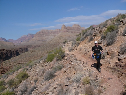
Running along Garden Creek to Indian Garden
As I neared Indian Garden, I started to run into hikers descending into the canyon. Around a corner, I was startled to almost run into a deer with a nice set of antlers. It wasn’t bothered by me and just walked up the trail. Soon I saw three other deer within ten feet of me who just looked up at me as I passed. I reached Indian Garden around 8:00 a.m., drank up, and filled my bottles. It was still very cool and I believed I would be OK with ony two bottles for the next ten miles. If I did run out, there would be a spring off the trail in about eight miles.
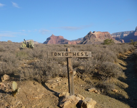
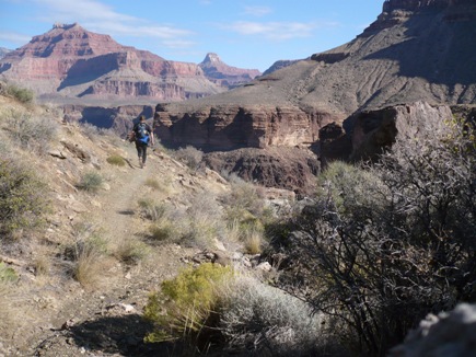
Heading out toward Plateau Point, I finally arrived at the West Tonto Trail at 8:15 a.m. The Tonto Trail runs along the Tonto Platform, a large shelf that is about 1,000 feet above the Colorado River. The trail rolls up and down and goes in toward the head of drainages and out again toward the river.
The Tonto Trail has a rich and varied history. Most of the trail began as an old route or footpath that was created and used by the Indians that inhabited the Canyon at one time or another. When these people were occupying and farming the depths of the Canyon, it was probably considered to be the original highway for the area. Many sections of the Tonto have been modified due to the wandering of feral burros and in some places this can make the trail difficult to follow.
After going past Horn Creek, I pulled out the Satellite phone and called my wife, a short 50 second call to tell here that I was doing fine. After that, I noticed that I had some text messages. Carl, a backpacking buddy from Virginia, who had paced me at Vermont 100 and Leadville 100, wrote to me: “You suck. Go faster. You can go faster than this. My grandma could run faster than you. -Carl :-)” I laughed and tried a little harder to increase my pace. Also I received a message of encouragement from Mark Ellison, a running buddy.
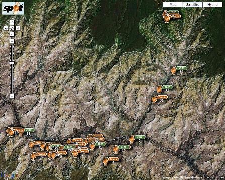
Map showing the signals I sent during the run.
Those watching me could zoom in and see the trail.
This was really wild. I was being watched! The Spot Messenger was working. They could send me messages and watch if I was still moving. Carl later told me, “Glad I could help from the comfort of my armchair, 2,000 miles away. It was surreal to watch a little blip move across the Grand Canyon and knowing YOU were that blip. But it was also a lot of fun to see ‘Where’s Davy Now?’ I think we could make it into some sort of game. You could just tell everyone you are going on a trip and then we could tune in to see where you are!”
As I ran along thinking about my friends watching me from the sky, I wasn’t paying attention and soon kicked a prickly pear cactus. A needle went into me foot and broke off. I had to take my shoe off and for about ten minutes dig and scratch that needle out of my foot. Finally it was gone. What a relief. But my thoughts were, “Gee, I better get going so my friends will not think I’m taking a break.”
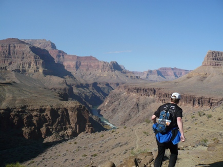
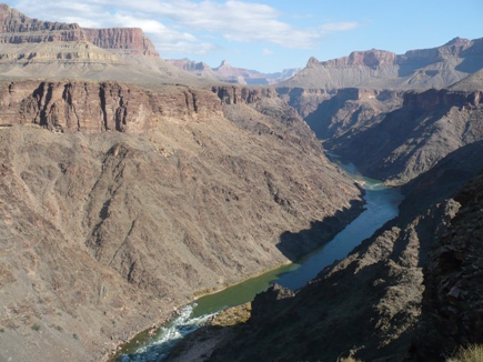
Amazing view looking toward Granite Rapids
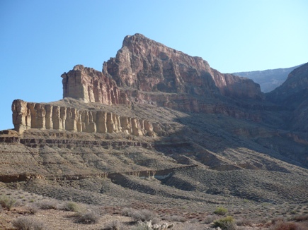
The trail made a huge swing back toward the rim, crossed Salt Creek, and then approached close to the cliffs above the river. The views were incredible as the morning sun started creeping further down into the depths of the canyon.
After running through Salt Creek, I made this audio recording
Later, I continued, “I’m descending into Monument Creek.. I’m having a blast, this is just great! The weather is perfect. It’s gorgeous. I ran into two backpacking groups. One said they would camp at Horn Creek. The guide of the other group asked me where I came from. I told him, and he understood how far I have come already. As I descended into the next valley, all the backpackers stood on the ridge and watched me as I ran down the trail. The sun is warming me, but is not too hot. I’m on some rocky switchbacks descending into Monument Creek. Down in the drainages it is much greener, with trees and bushes. Oh, I see some backpackers down on the trail watching me! I’ll go down there and refill my water.”
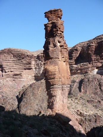
The Monument
At the creek, I took a long stop to filter water and get something to eat. Climbing out the other canyon, I met several more backpackers. The trail was full of holiday hikers. They sure chose a great week to explore the canyon.
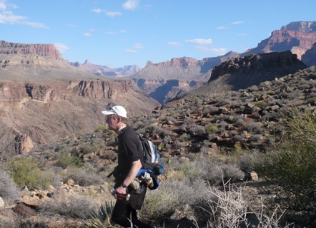
Running above Monument Creek Canyon
As I made a tough climb out of Monument Creek Canyon, I spotted a guy and girl ahead of me. They were moving well, even with heavy backpacks on. I finally had a good challenge. I set my sights on them and pushed hard to catch up. I finally did and they gave me curious looks. I went on ahead, but they kept catching up as I took my sweet time taking pictures. I think they got a kick out of watching me set up photos with my timer.
I crested a high hill and started the descent toward Hermit Creek. The Hermit Rapids could be seen and heard, far below. I left the backpacking couple far behind.
My backpacking buddy and pacer at Wasatch 100 and Leadville 100, David Hansen, sent me a text message: “It’s much easier watching you on a map instead of running behind you! Hope all is well – oh yeah…Get your lazy butt in gear and run!!”
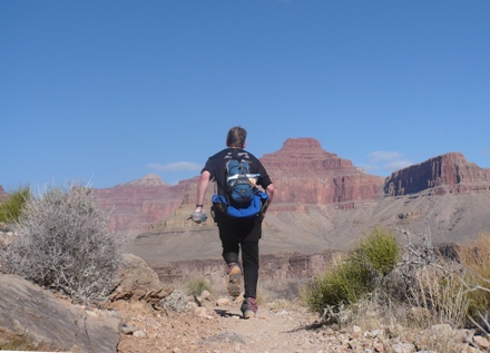
Running down toward Hermit Creek
From Hermit Creek, I was seeing new views that I didn’t see in the light a year ago. I headed toward Boucher Creek and still intended to make the tough climb up Boucher Trail to the South Rim. But I didn’t fill up my camelback bladder at Hermit, and decided I would do that at Boucher Creek. This would mean I would have to go a half mile further down into the creek to get water before the long trip up the rim.
Stunning view looking up the river at Hermit Rapids below
The trail swings very close to the cliff above the river. Last year this was freaky in the dark. I knew the trail was exposed and could hear Hermit Rapids roaring below in the dark. This year the view was incredible.
I became amazed at how tough the trail was becoming. Clearly this section of the Tonto just doesn’t get as much backpacking traffic. The trail went up and down steep stretches that were full of rugged rocks. My pace became frustratingly slow. Finally at 2:00 p.m., I made a decision. I recorded, “Well, I decided to wimp out. I’m three hours behind schedule. That means I would have to come back down from the rim in pitch black. I look up to that rim and I know I just don’t have that in me. I would rather have an enjoyable time running on the Tonto Trail. So what I will do is continue to head to Boucher Creek and then turn back, maybe visit Hermit Rapids. Still, this will be close to 80 miles. That’s plenty. I’d rather have a fun time. I’ll take my time and take more pictures.” I know that was a good decision. If I climbed up to the rim, it would be very cold at the top at dusk and the facilities at Hermits Rest would already be closed. It would be miserable.
Running down into Boucher Creek
When I didn’t make the turn up to Boucher Creek, my backpacking buddy and pacer at Wasatch 100 and Leadvill 100, Brad Clements, noticed by looking at my satellite tracks, that I didn’t turn up the Boucher Trail. He texted me, “Looks like you made a wrong turn at the Boucher Trail junction!” Well, soon they would know the truth, that I wimped out.
At about 3:15 p.m., I reached Boucher Creek. I filtered some water and then went to join a backpacker for dinner. It was his first experience in the Canyon. He was with two others who go to the Canyon each year. He could not understand where I had come from and kept asking if I took a shuttle and if not, how did I cross the river. After resting and eating, I bid goodbye and then went to talk with his buddies. They invited me to camp with them, but I explained that I was going on. They were stunned as I explained that I had come about 40 miles since the early morning and was now turning around to head back. I waved goodbye and they all watched me climb quickly out of Boucher Canyon. I was now much more determined to keep a good pace going. I no longer would spend a lot of time taking pictures and would just hope that the Spot Messenger was working fine. My “watchers” from the sky noticed that I had stopped Carl sent: “Greetings. The sunset is likely beautiful as dusk awaits. I see you are behind by a bit. We are all rooting for you. Looks like you rested for 25 mins around 4pm or maybe made a sat call. Best of luck on the climb up. Its mostly downhill after that. Go Davy Go!!! You slow poke.” Soon he learned the truth. “Looks like you decided, smartly, to cut it short a bit. Good move. Stay warm and eat. Make sure you eat something if you have it. I will be with you tonight.” Yes, my pacer, even 2,000 miles away was on my case, telling me to eat and to get my butt in gear.
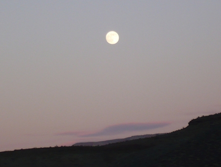
The moon rising above the Grand Canyon
As the sun went down, the animals came out. There were three bighorn sheep and a deer high up on a steep cliff. I just couldn’t comprehend how they could stay up there without falling. Another buck watched me on a ridge above and kept going ahead of me. I arrived back at Hermit Creek as the sun went down and took out my flashlight. There were quite a few campers in the campground. One of them greeted me and mentioned that he had seen me much earliar heading in the other direction. As I climbed out of Hermit Canyon, I ran into several people making their way down without lights – not a very smart thing to do. One guy was at a trail intersection and asked me the way to the camp. I told him, but he didn’t believe me and wanted to go on the other trail. I told him to trust me, that I had just been to the camp. Oh well. The sun was gone and the glorious moon replaced it as an amazing source of light. I was thrilled to have the moon with me for the entire night. At times I was able to turn my light off because it was so bright. Going toward Monument Creek, I noticed that I dropped my glove. I went back for several hundred yards, but didn’t find it. I thought about it and decided I could use an extra sock to keep me warm.
I arrived at Monument Creek, at about 7:00 p.m., I stopped again for about 25 minutes to filter water, eat some food, and arrange things for the night. I could see the lights of some campers settling down for the night. The next three hours were pretty uneventful. I kept a good pace going and didn’t stop for any rests. At about 11:00 p.m., Carl sent a message, “Looks like you are doing OK and about 2 hours behind the pace you originally set, all be it without the short cut. But the key is making it back safe. Its 1:00 am in the morning where I am. Just wanted to send some spirit to you in the dark.” Wow, that is an amazing friend. Throughout the night I spent a lot of time thinking about what I could say interesting in the radio interview later in the morning. I hoped that I wouldn’t sound like a weirdo.
I had a bad sleepy spell and that means hallucinations started. The rocks started to look like people and houses. It bothered me so much that I forced myself to just look down at the trail and my feet.
I arrived back to Indian Garden at midnight and took a long bathroom break. The camp was quiet and dark. I was slowing down. I went down Devil’s Corkscrew and continued through Pipe Creek Canyon. At 1:00 a.m., I recorded a very, very tired, funny message. Listen to the audio recording.
I reached the Silver Bridge over the Colorado River at 2:00 a.m. I paused to send an OK message on the Satellite Messenger. Carl saw the signal when he got up several hours later: “And just 5000 feet and 10 miles to go! Go Davy!” Phantom Ranch was quiet as I ran through it. At this point, things really got tough. A cold wind started to blow down the canyon through The Box and it sapped my energy. I put on another layer, my last, and it helped a little. If I pushed it, I could be at the top by about 7-8:00 a.m. But as I thought about it, I knew it would be terribly cold. I needed the sun to warm me up. I lost all my motivation to keep moving at a good pace.
Next, I became terrible sleepy. I had not had any good sleep for about 45 hours. For the next two hours I stopped several times to take cat naps behind rocks to shield me from the frigid wind. These little naps only lasted for 5 minutes or so, but they seemed to help. Finally after almost four long hours, I reached Cottonwood Campground at about 6:15 a.m. and prepared for the call to the Utah Outdoors radio show. The wind was fierce. I worried that they wouldn’t even be able to hear me with the howling, cold wind. I looked around for a place to get out of the wind. First I tried to set up inside the bathroom, but I couldn’t get a good signal. Next I opened the bathroom doors as a wind shield and had a good signal. I dialed the number but soon lost the signal. I had no choice but to climb up a slope and there I found a good signal. I called again and was on hold for a couple minutes waiting for them to bring me on. Just as they did, the signal went dead. Oh no! I rushed up the slope further, no signal. Then it came back, but for the next several minutes I was just too tired to dial correctly. I again lost the signal. Next, I sprinted down the trail for about a half mile to a location with better sky visibility. Finally I again had a signal and made the call. I think the interview went fine. My mind was pretty wasted after 48 without sleep. I lost the signal during the interview, but quickly called in again. Finally I lost it for good and just gave up. Oh well, I did my best.
I returned to Cottonwood Campground where my stuff was scattered near the bathroom. Thankfully a backpacker there hadn’t disturbed my stuff. I’m sure she wondered why it was there and why the bathroom doors were propped open.
Well, with that long hour delay, dawn had arrived and I had new fresh energy. I had a terrific pace to Roaring Springs and above. But finally at the last bridge, I had a major bonk. I just had not been eating well for the past couple hours. I had no choice but to stop, recover, eat, and then start moving slowly up the trail. The next three hours were a death march that I am very familiar with. The sun warmed me. I pushed on ahead, greeting a couple ultrarunners running down the trail, one with an “Across the Years” shirt. Finally, at about 11:30 a.m., my journey was complete. I sent a last satellite signal and sat down on the soft seat in my car. I was surprised to see that a gallon of water I left in my car had about an inch of ice in it. It had been COLD at the rim over night.
I made the long drive home just fine, listening to the BYU vs. Utah rivalry football game. That kept me awake. Finally, that night at 8:00 p.m., I finally could sleep again. It had been another amazing adventure.
Review of Spot Satellite Messenger
Here are my thoughts about the Spot Satellite Messenger. I used two modes: 1. Tracking mode: Supposed to send signals every ten minutes. Over the 33 hour adventure, only about 30 of these signals were received. However it was good enough for my friends to get an idea where I was. At times it was pretty consistent. It felt like my buddies were right there with me. I felt more confident being is a very remote place. 2. OK mode. Once per hour I would press an OK button to send a signal. This signal was sent via email to those of you who signed up. Only 9/35 signals were received.
Challenges:
1. Few signals were received on the North Kaibab trail due to the high walls. 2. The blinking lights on the unit just don’t give you enough information to know if your signals are working. 3. When you send an “OK” it seems to disable the every-ten-minute tracking mode. When I remembered, I would reset the unit ten minutes after sending an “OK.” That was a bother. 4. The unit does a better signal if lying flat. By wearing it on my belt I lost half of the sky. Doing it again I might rig it on my hat. 5. Because of the above challenges, it slowed me way down fiddling with the unit.
Overall, I thought it was very cool. My backpacking buddies who saw all 40 signals had a great time tracking me. I am very tempted to buy one of these units. If you choose to purchase one, please buy one from Russ Smith at Skycall. He will throw in some free batteries.
Great write-up, Davy. I think the addition of the clips from your voice recorder MAKE the write-up so much more real. They remind of this new kind of photo slide show thing people are doing like this:
http://mediastorm.org/0018.htm
Another suggestion on the sound files, I think if you do something like this:
audio recording” target=’_new’>
…you can have the audio content pop in a new window so people can continue looking at the images while they listen to the audio.
I loved the hallucinations. Very cool.
Sounds like it was a cold trip overall. I don’t think I would have enjoyed it much. I was cold when it was 50° in Leadville and that was 11pm at night!
Love, Carl
Pingback: Carl Hutzler’s Blog » Davy Crockett Runs the Grand Canyon
Great story. I read all of it with fascination.
I was with Carl when you were doing it and was thoroughly fascinated and impressed. Guessing what was going on was fun too.
The recording reminded me of a story a pilot told me. He was going on a neat trip over the Rocky Mountains and he was going to take his son with him. Unfortunately the son got sick the day of departure, so dad took a tape recorder and recorded everything [voice only] he saw and along the way.
When he played the recording a couple of weeks later he was shocked at how he sounded when he was above 14,000 ft. His words were slurred and incoherent, very much the recording you supplied.
At least you were on the ground.
I added the interview as an MP3 on my site. This may be easier for many folks. The .mov file still works as well.
http://carlhutzler.com/crockettsatphone1.mp3
Hey Davy,
I’m heading to the Grand Canyon to attempt a quad-crossing three weeks from today. Would you be willing to email me at fredx@pobox.com? I’m seeking any sage advice or notes on the trails, water, caching food/clothing, etc.
Thanks a lot,
– Fred Ecks