Lake Mountain rises 3,200 feet behind my home. Much of my training takes place in its foothills. A week ago I finished Salt Flats 100 which was a good race for me. I recovered very fast and by Thursday was itching to run again. On Friday I tested things out and did a tough run from the Utah Lake shoreline to the top of Lake Mountain, a 12-mile round trip that climbs 3,200 feet. I felt recovered and again ready for a long run this weekend.
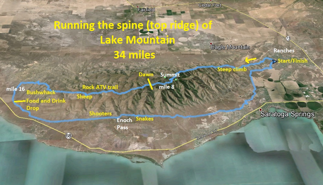
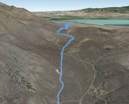
I decided to do some unfinished business. I wanted to run the entire Lake Mountain ridge line all the way from Eagle Mountain Ranches to the Soldier Pass road, about 16 miles. I once did this, but not quite right, I skipped the last two miles of ridges and descended into a valley and didn’t run all the way back around to my starting point. I wanted to go the entire distance without using any valleys to go up or down, something I’m sure no one has accomplished before. Yes, it would be pretty crazy and required some careful study and planning, but it would be possible.
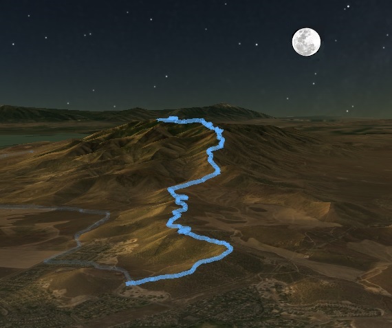
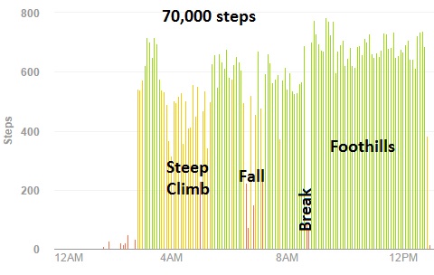
I started my journey at about 2:45 a.m., parking my car by a home on the far north end and started to climb the ridge. All was quiet in the early morning and a nearly full moon lit up the night landscape. After climbing up about 300 feet the ridge rolls for the first three miles separating Eagle Mountain from Saratoga Springs. This first three-mile ridge was a familiar route, mostly traveled by motorcycles and ocassional runners. Lights from homes below glowed as I pushed the pace to the south faster with my bright green light to guide me. I love the peace of running in the very early morning high above busy cities below.
At about the three-mile mark the route seriously climbs more than 2,000 feet over the next 3.5 miles. There isn’t really a trail on these ridges, just deer trails. But this year it looked like a defined trail was forming either from hikers or consistent deer tracks. In the dark it was hard to tell how far away the summit was, and at times I thought it was close, but than another climb appeared. The temperature was pleasant for running, in the upper 40s, but as it became cooler the higher I climbed, I stopped to put on long sleeves and my gloves.
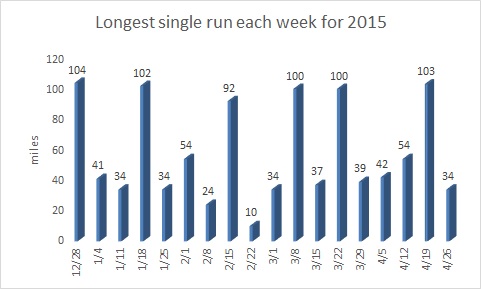
As I climbed, I thought about my string of long runs each week. This was the 18th week of the year and I had accomplished a single run every week of at least 34 miles except for two weeks. I had a string of eight weeks going, and this would be my ninth. In both March and April I ran more than 400 miles. I really didn’t plan to run high mileage months, but with no significant injury to slow me down, I just enjoyed getting out and running often. I’ve also never finished five 100-milers in the first four months of the year before. It has been a good running year so far this year despite my advanced age of 56.
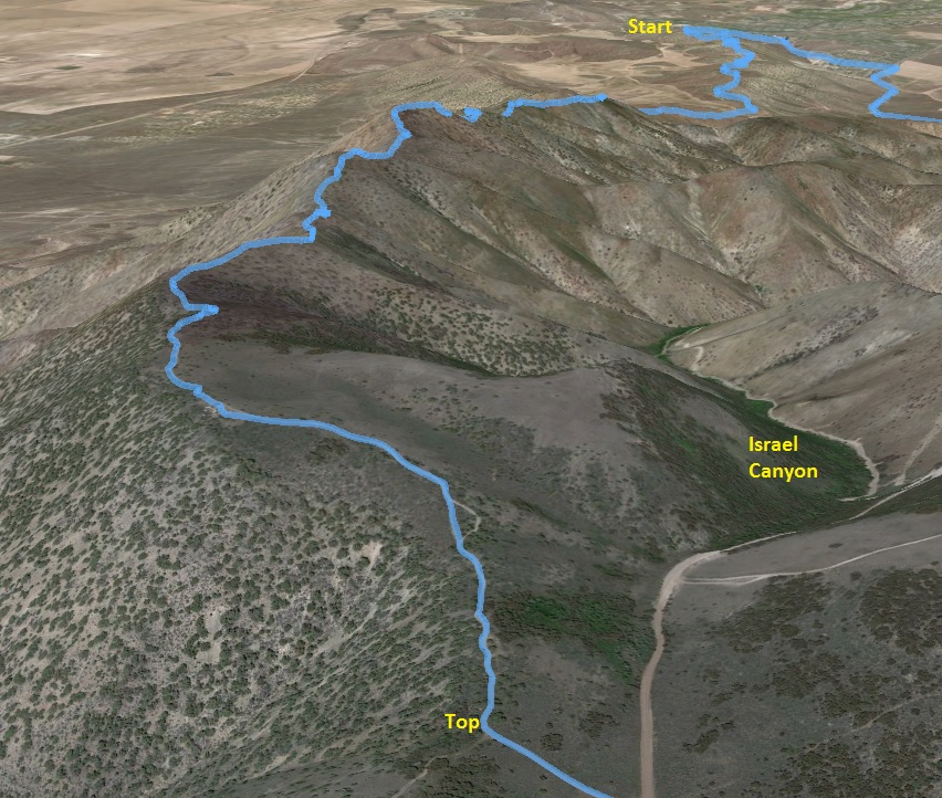
I finally reached the high point of the ridge 7,645 feet, not quite the true summit which dead-ends a half mile to the south but I was just a few feet below the high point of the mountain. I reached the top after two and a half hours. That is a slow 6.3 miles but was a tough climb in the dark. I descended a little to the pass at the top, running on the main road to connect again with the main ridge heading to the south. It is all pretty confusing up there with many dirt roads, but I succeeded to go the right way in the dark. I passed by some guys camping with a fire. They shined a head lamp at me wondering what in the world a guy was doing running up there in the dark with a green light.
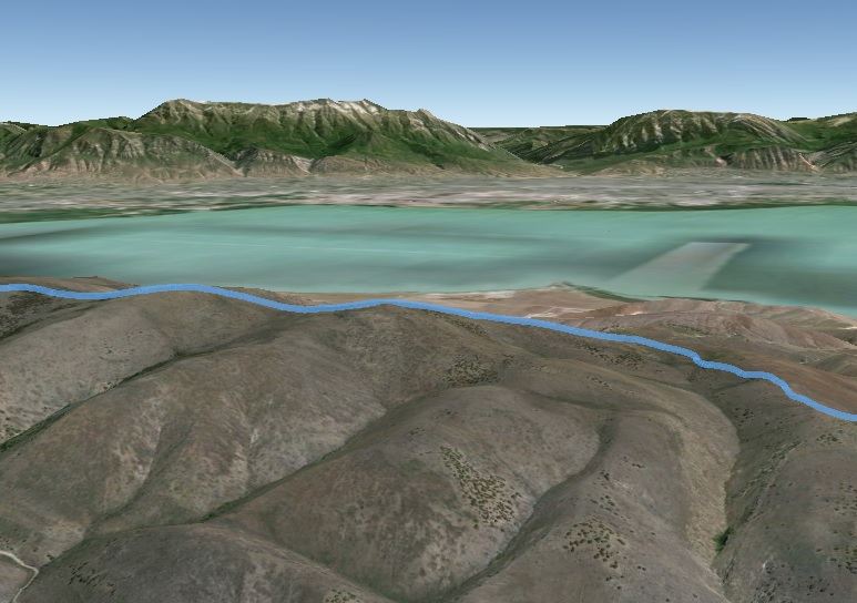
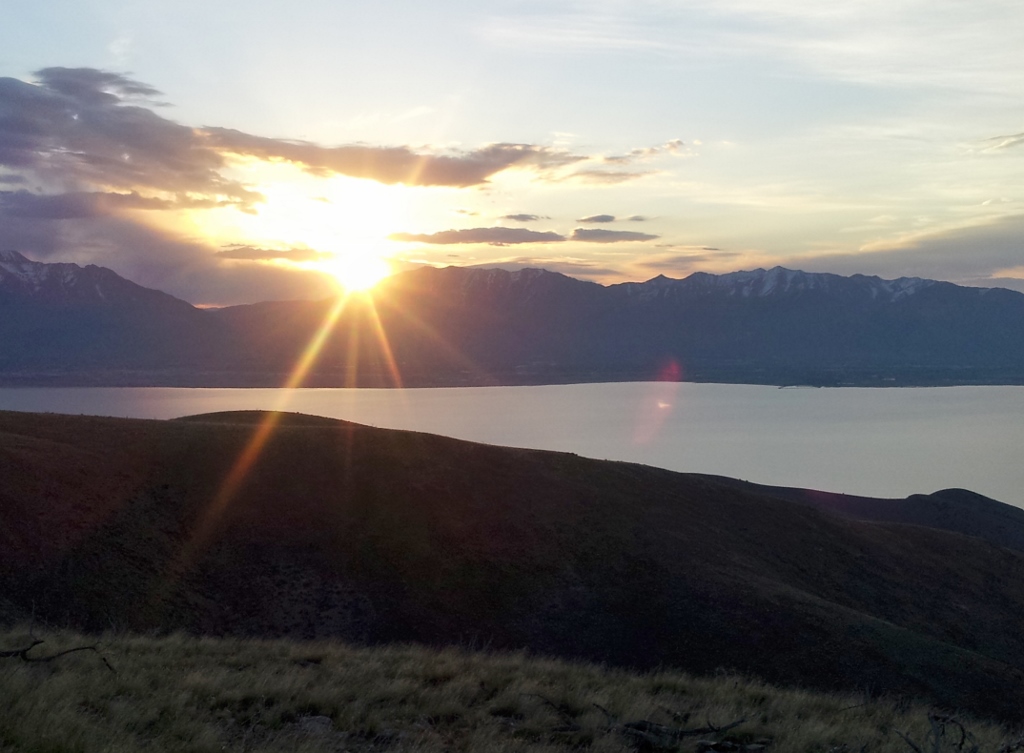
I next ran past many utility towers and eventually was on the ATV trail what would extend for miles on to the south, staying close to the top of the ridge. Dawn soon appeared with a red glow above the mountains to the east and soon the warm sun made its appearance. A new day came to life and looking down and across the lake I knew there were tens of thousands of people starting their busy days, but up on the mountain ridge it was quiet and peaceful.
At about the 10-mile mark my route started the long descent as the ridge started to fall toward the desert floor for the next six miles. The trail was very rocky and it was hard to keep a good pace going. I tried to push the pace faster on a downhill and immediately tripped and flew straight forward. My fall was very hard, my worst in more than six months. It was one of those falls that makes me lie there for a minute, wondering if I broke anything. My weight hit my left shoulder hard and a bruise quickly started to swell. I next noticed a finger nail on my right hand had been nearly torn off and was bleeding pretty bad. I had various other cuts but the worst was a sprained right wrist. I was slow to get up but finally did and cleaned myself up. Falls like that are so hard on my old body. I continued on slowly with blood dripping from my finger. I would live.
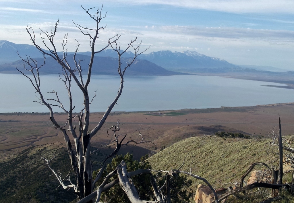
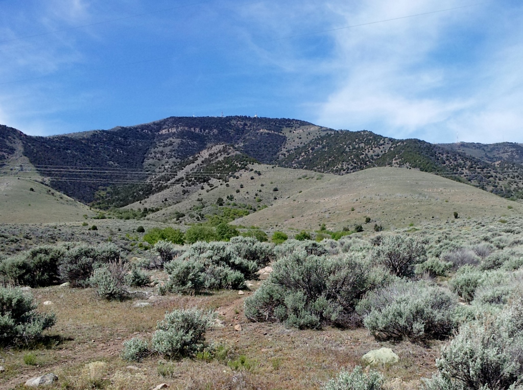
The morning was beautiful. The views of Utah Lake below with the snow-capped Wasatch mountain range behind. It was so peaceful with only the sounds of birds chirping in the morning light. Over the past several years, fire has devestated more than half of the moutain caused by target shooters below. I ran through many “groves” of burned cedars.
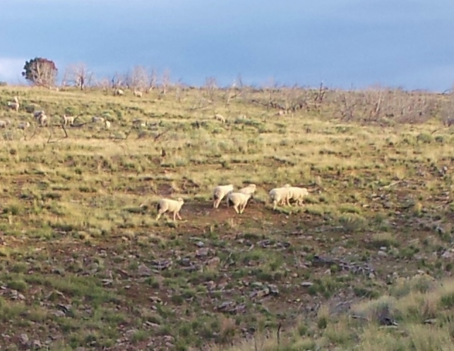
Soon I heard bells. I came upon a small herd of sheep, which was a surprise. I had never seen sheep up there before. They had come up a valley from the east and were sticking together pretty well. When they saw me coming they ran away to the top of a nearby hill.
At about the 13-mile mark, the ATV trail heads west and descends into a valley exiting out of the mountain. I wanted to stay true to the ridge so left the trail and ran true cross-country. It was great fun and very obvious that no humans had traveled this way. There was no trash and no tracks. The surface was soft and easy to dodge the bushes and trees in an area not touched by the fires. It was now a creative exercise to figure out how to stay on the ridge that would get me furthest to the south and have the best descent. I did need to cross a few passes, but found the ridgeline I wanted. The desert floor came closer and closer and I saw clearly the area below where I had dropped food and water the night before.
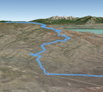
My ridgeline run was finished. I had successfully run the entire length of the mountain. I reached my cache, filled my camelback and handheld bottle, ate nearly all the food and felt much better. I was now at the 16-mile mark. My return trip would along the eastern foothills. I would avoid running on any pavement, on nearby Redwood Road that travels the shoreline and insteady would stay up in the foothills.
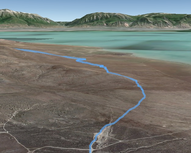
Because of the past fires in the area, most of the sage brush was gone in huge areas. In its place, in the early spring was just some soft low grass and occasional rocks. Instead of following dirt roads, for the next three miles, I just ran cross-country across the foothills in a straight line to minimize my miles. It was soft and great fun. I eventually joined up with the power-line road and then pushed the pace on a long uphill to Enoch Pass. I ran by a couple groups of shooters, but they were being very responsible, not drunks, and waved as I ran past.
At the 23-mile mark, the power-line road went up and over Enoch Pass, a climb of about 1,000 feet. Down the other side I eventually left the main power-line road and again ran a straight line cross-country toward the developments to the north. I almost stepped on three snakes along the way but they weren’t rattlers. The only other wildlife were many jack rabbits. The scariest part was running past groups of target shooters, but today they looked like responsible shooters, not the drunks who trash the mountain. They waved at me as I ran by. The late morning was getting warm, but I had plenty of water and felt pretty great. I came within a mile of my home but still had four more miles to reach my car.
The car finally came into sight. I had run nearly 34 miles. My pace was pretty slow, averaging 16:31, but the climbs were tough and the trail at the top was rough. It had been a very good tough run. Yet another 34-mile run in the books. I also climbed more than 6,000 feet along the way.