

May 5, 2005
Over two years ago, I considered hiking across the Grand Canyon, rim to rim. I later wisely dismissed the idea. I wasn’t in proper shape and I would have suffered. Rim-to-rim hikes or even day hikes from rim to river and back are strongly discouraged by the National Park Service. Rescues are frequent. People overestimate their abilities and underestimate how strenuous such an adventure can be. Another key factor is the hot temperature of the canyon. Temperatures in the lower canyon are typically more than 20 degrees hotter than the rim. Many hikers end up suffering from heat exhaustion.
Now in much better physical shape, instead of hiking rim-to-rim, I decided to run rim-to-rim-to-rim. Crazy runners usually perform such attempts in April or October, when the temperatures are moderate. My attempt was on May 7, 2005 Two weeks ago I had run the tough Zane Grey 50-mile race. My recovery had gone well and I was ready for another challenge. The road to the North Rim was still closed because of late season snow, so I had to make the long drive from Utah all the way to the South Rim.
I drove down on Friday, arriving before dusk. Numerous large thunderstorms rolled through dropping some sleet and snow on the South Rim. The forecast for Saturday sounded perfect – cool temperatures, clouds, but probably no rain. I went and found the Bright Angel Trailhead so I could find it quickly for my early start in the morning.
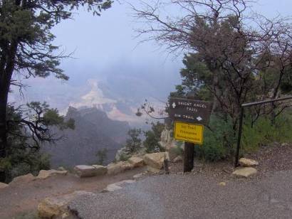
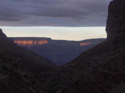
Bright Angel Trailhead on Friday
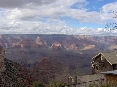
The canyon is filled with clouds from storms
I checked into a motel, ate a pasta dinner, made run preparations, and did my best to try to get some sleep. The weather was a worry. The rain continued to fall until shortly before midnight. I was hopeful that the wet trail wouldn’t be a bother. The inner canyon typically receives only half the number of inches of rain as compared to the rim because the water evaporates before reaching the hotter canyon floor. My attempts for sleep were fruitless, but I did get a little good rest. At 1:00 a.m., I decided to pack up and get going.
There are two trail options from the South Rim – South Kaibab trail, or Bright Angel Trail. The South Kaibab trail is shorter, steeper, no water, and no parking at the trailhead. I decided to stick to the Bright Angel Trail. My rim-to-rim-to-rim (R2R2R) route would cover about 47 miles. I would start at 6800 feet on the South Rim, descend to 2400 feet, cross the bridge over the Colorado River, climb to 8240 feet at the North Rim, and then return. Altogether, the elevation gain, including some ups and downs along the way would be about 11,000 feet.
My goal for this run was 14.5 hours. I estimated split time goals and taped my goals to my hand-held water bottle. I knew that water would not be a problem along the way because water faucets were turned on along much of the trail and there were plenty of streams along the way up to the North Rim. I took with me a small backpack containing food, an extra water bottle and some rain gear (which I hoped I wouldn’t need).
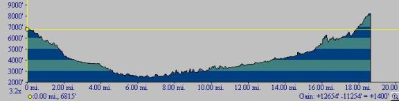
Elevation profile from South Rim to North Rim
My adventure began at 1:30 a.m. I enjoy running at night and looked forward to some good, technical night training. I would be crossing the Grand Canyon solo in the dark! Was I crazy? The temperature on the rim was in the low 30s. I dressed in shorts and a long-sleeved shirt. In one hand I held a water bottle, in the other hand I held my very bright 14-bulb LED flashlight that illuminated the trail nicely. I heard the howling of several coyotes somewhere on the rim as I began my long run.
The first leg of the run, to a trail rest stop covered 3 miles and descended nearly 2,000 feet. The trail was soft, soaked with puddles, but thankfully wasn’t slippery with mud. I started running carefully down the numerous switchbacks. I glanced at the sky and was pleased to see some stars as the weather had improved. The greatest challenge during this steep downhill run was the danger of tripping. I couldn’t see the steep drop-offs in the dark but I knew they were constantly there. I quickly learned that I could not take my eyes off the trail while running for any reason, even for a glance at my watch. I decided on a firm rule: First stop running, then look.
The Bright Angel Trail is well maintained. To prevent against erosion, they use logs across the trail that form steps along steep sections. Puddles formed on these “steps” creating technical obstacles for me to avoid. I could try running near the edges or dodge the puddles. At times it felt like was skiing through moguls. Like mogul skiing, I would make my turns on the top of the bump (log), and try to keep going straight down the “fall line” instead of zig-zagging back and forth too much.
I was having a blast! I was cruising down into the most famous canyon in the world, all alone in the dark. I was astonished how fast I lost elevation. I could see a few lights from the lodges on the rim high above me. I was concerned about the downhill pounding on my problem knees. Normally, I would try to use gravity effectively and float down the trail, but with cliffs falling off into the dark of the night, I cautiously braked to slow down my pace. As a result, the knees started to complain from all the work.
I reached the 3-mile mark at 0:37 (elapsed time), just one minute off of my goal. I was able to pick up the pace because the trail started to have more runable sections as I approached Indian Gardens Camp Ground (mile 4.6). I arrived at 0:57, three minutes ahead of schedule. I had already descended over 3,000 vertical feet. I could now hear the soothing sound of flowing water in Garden Creek. The path took me across the creek several times. I managed to keep my feet dry as I danced on stones in the creek bed.
As I kept descending, the air temperature rose toward 50 degrees causing me to sweat pretty well. I cruised down another series of long switchbacks (Devil’s Corkscrew) and then headed north, in the direction of the Colorado River. Finally a loud roar could be heard. I reached the River Trail (mile 7.6) at 1:41 and headed west along a rolling trail high above the roaring Colorado River. I tried to shine my light down, but could not see the river through the dark.
I soon reached the bridge (Silver Bridge) that spans the mighty river. I paused to take some pictures and then continued my run across the bridge, causing it to bounce a little, giving me a dizzy feeling.
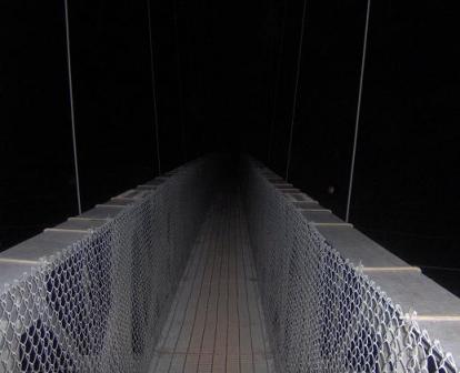
Crossing Silver Bridge over the Colorado River
On the other side of the river, I passed several buildings – civilization at the bottom of the canyon. I found a water faucet and filled up for the first time. I drank about 30 ounces, making sure I was well hydrated, and then continued on my way, passing Bright Angel Campground. I carefully read signs along the way to make sure that I was heading toward Phantom Ranch. I arrived at the ranch (mile 9.6) at 2:11 elapsed time (3:41 a.m.), 11 minutes off my goal time. Some buildings were lit up and I wondered if anyone could see me, a crazy runner with a bright green light.
A sign pointed the way to the North Kaibab trail. I read a warning notice that stated that Wall Creek, about six miles ahead was flooding, and that hikers were strongly discouraged from crossing and going north of the creek. A few days earlier, a friend forwarded me an email from someone who run the R2R2R two week earlier. “during our crossing [Wall Creek]was a raging torrent that required a scary thigh-deep crossing on the outbound and return legs.”
I continued running past the sign but had a worried feeling. Would the creek be raging even more because of the thunderstorms earlier in the evening? Would I have to turn back? Would I be too daring, fall into the creek, and be dragged down the river? To add to my worries, the trail took me along the roaring Bright Angel Creek, flowing with tremendous force just a couple feet from the trail. I could hear massive boulders moving in the river from the incredible push of water.
I was now running uphill and entered The Box, a massive canyon, carved out by the Bright Angel Creek flowing down from the North Rim. My flashlight illuminated the steep canyon walls climbing more than 1,500 feet on both sides. At times the canyon was only 50 feet wide. Feelings of isolation and continued worries about the creek crossing ahead tended to slow down my pace even though the trail was very runable. I was thinking that perhaps I should slow down to make sure that I crossed the creek with the aid of morning light.
I pushed on ahead, crossing several bridges over the roaring river. My elevation increased, the canyon opened up, and when I looked behind me I could see the twinkling lights of the South Rim many miles to the south. Gradually the morning light started to appear. When I reached the Ribbon Falls Trail Jct. (mile 15), I put away my light. I arrived at 3:45. I was disappointed to discover that I had slowed to 45 minutes behind schedule. I couldn’t remember which way to turn at the junction and of course first headed in the wrong direction. I soon discovered my error and backtracked.
Looking back to the South Rim lit up by the morning sun.
Clear skies in the distance
The trail took me through some swampy sections. As I was trying to keep my feet dry, I considered how silly that was because of the creek crossing ahead. I ran across several dry washes and almost convinced myself that the creek was dry, that I had already crossed it. But soon I heard a strange roar away from the river and I came upon Wall Creek. My first thought was, “I can’t cross that!” The trail crossed above a waterfall. One goof and I could be swept over the edge. I approached for a closer look. I would give it a try. I put my water bottle in my pack to keep my hands free and tentatively entered the creek. The force of the water pushed against my legs as I struggled to get some good footing. I was delighted to discover that the creek must be lower than two weeks ago; it only came up to my knees. I made the crossing without much difficulty feeling silly about my worries.
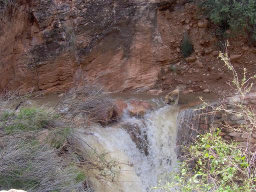
Wall Creek Crossing, above falls
With that worry behind me, I put my concentration on the long climb ahead. The trail started to become steeper. I soon arrived at the beautiful Cottonwood Campground (mile 16.5). There were a few tents set up but no one was stirring. It was still early, 5:43 a.m. I was now 53 minutes behind my schedule. I stopped at the ranger station, filled my water bottle and then looked for a place to stash my small backpack. I still had 4,240 vertical feet to climb to the North Rim. I only wanted to haul up the essentials.
My legs were holding up great. I marveled that my muscles didn’t feel tired yet. I felt strong and knew there was no turning back now. I could still run the mild uphills, but now mostly resorted to power-hiking. My wet feet did have a few problems. A couple blisters were forming but they weren’t a problem enough to stop and fix.
I reached the Roaring Springs trail junction (mile 18.6, 4.7 miles from the top) at 4:57, 47 minutes behind schedule. I couldn’t remember which way to turn, and again wasted time going the wrong way, visiting Roaring Springs. I thought it was odd that at several of the buildings I passed along the way, there were windsocks for helicopter landings, a clue that there have been many rescues in times past.
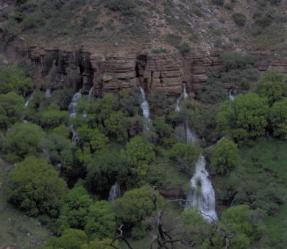
Roaring Spring, pouring out of the canyon wall
After wasting 15 minutes, I returned to the correct trail and continued the steep climb toward the North Rim. The rim, high above, was covered in snow and obscured by clouds. It looked cold. So far, the temperatures had been ideal for running.
I soon realized that I had left too much food behind in my backpack stashed at Cottonwood Campground. All I had was a flask of Hammer Gel. I would have to ration the rest of it. I felt a low-carbohydrate bonk coming as my energy decreased.
At a set of switchbacks, I discovered that there had been a bad rockslide during the winter. Huge boulders blocked the trail at several points that I had to climb over. Shovels and other tools were stacked nearby, ready for some hard working trail workers. There is no way that mule trains could come down the trail until these massive boulders were removed.
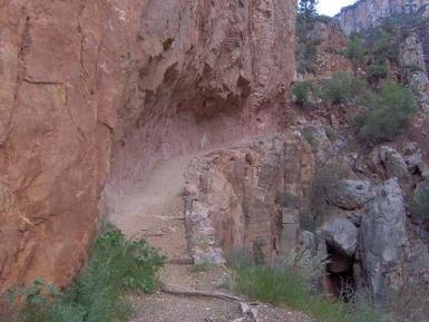
Trail carved into the wall, next to cliff
Up and up I went. It seemed that the top would never be reached. I arrived at Supai Tunnel (mile 21.3, 2 miles from the top) at 6:18. I was now a little over one hour behind schedule.
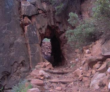
Supai Tunnel
After the tunnel, snow started to appear little by little. I felt cold, hungry, and tired. As I climbed higher, the snow became deeper. First an inch, then two, and then I was walking through one-foot drifts. Some curious tracks from a huge bird led me up the trail. My wet feet were becoming very cold.
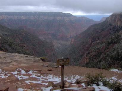
Coconio Overlook, right below the fog
I climbed into the clouds and plodded on. The trail started to level out in the forest and suddenly the North Kaibab trailhead appeared! I arrived at the North Rim (mile 23.3) at 7:07, 1 hour, seven minutes behind schedule. The drifts were several feet deep, but the road was plowed. I heard the sound of a truck in the distance heading my way. I waved at the passing maintenance truck. I wonder what the guy thought, seeing me in shorts and running shoes, standing next to several feet of snow, out in the middle of nowhere.
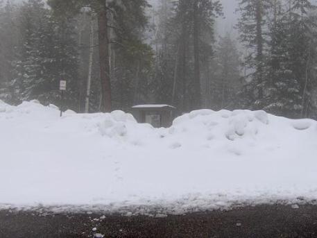
North Kaibab Trailhead
Ok, now all I had to do was return. All I had was a simple task of crossing the Grand Canyon again. I didn’t dawdle at the top. I snapped a few pictures and then looked forward to getting out of the cold. After five hours of constant uphill, I now enjoyed running fast downhill again. I got into a nice rhythm and was surprised that my knees didn’t hurt much. I descended quickly and arrived back to Supai Tunnel (mile 25.3) at 7:35. I was gaining on my schedule, 50 minutes behind. I was disappointed to discover that the water faucet wasn’t working and I was almost out of water. Now I was almost out of both food AND water.
At the 26.5 mile mark, I was surprised to see the first human, another R2R2R runner! He asked me how close he was to the top. I told him that he still had about four miles to go. He asked about the snow and then we parted. I was 7-8 miles ahead of him, but would now really stretch the distance out because I had the advantage of running downhill. I arrived at Roaring Springs Trail Jct (mile 28) at 8:22, 57 minutes behind schedule. At mile 29, I ran into two more R2R2R runners. We stopped and talked for a while. They were also curious about the snow depth at the top. We wished one another well and parted. I considered that I was about 12 miles ahead of them.
My energy level was becoming poor. I needed food. Finally I returned to Cottonwood Campground (mile 30.1) at 8:56, 56 minutes behind schedule. At least I was no longer losing time to my schedule. I found my backpack and devoured sandwiches, a bottle of Ensure, and a banana. When I retrieved my backpack, a cactus stabbed me. The needle went deep into my leg and broke off as I pulled it out. It took me several minutes to finally pull out the half-inch needle. Ouch!
I talked with a couple campers who were curious about snow conditions on the North Rim. I quickly changed into my warm-weather clothes and soon was on my way. I re-crossed Wall Creek without any problem except I again had wet feet. I reached Ribbon Falls Trail Jct (mile 31.6) at 9:27, 1:07 behind schedule. What a terrible 50K time. Oh well, this was not your typical 50K run.
The run along Bright Angel Creek was spectacular. I came across many hikers along this stretch. When I saw them, of course I had to break out into a strong run. I still struggled to find energy.
Trail along Bright Angel Creek in The Box
It seemed like Phantom Ranch would never arrive, but I finally made it back (mile 37). I arrived at 10:53, 1:23 behind schedule. I was amazed to find it a busy place, filled with people. I marveled that some obviously out-of-shape people were at the bottom. I hoped that mules would be taking them back up safely. My original plan was to spend a half hour at the ranch, shopping at the store, fixing my feet, and changing into dry socks. But I had a running rhythm going, so I just ran on. I did stop briefly to call my wife, Linda, from the pay phone to let her know that I was at the bottom of the Grand Canyon and only had one hill left.
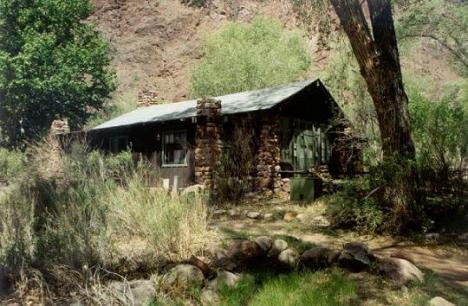
Cabin at Phantom Ranch
For some reason, in 50-mile races, I usually get my second wind around mile 38. I was delighted to discover that it happened again on this run. I felt strong, pain-free, and pleased to use my uphill muscles again. Another item for motivation was the numerous hikers heading back up toward the South Rim. I would set my sights on them, just like in races, and blast on by them. They would be surprised to see someone running, and little did they know that I had already traveled almost 40 miles today.
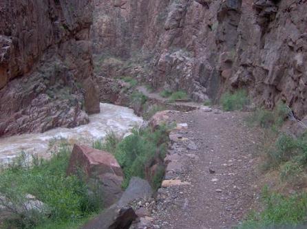
It was nice to see the trail in daylight. The massive Colorado River was impressive. A large group of rafters were beached on Pipe Creek Beach below and they watched curiously as I ran by on the trail.
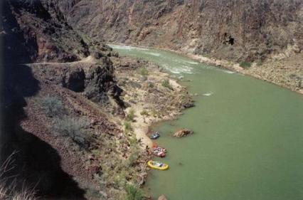
Trail above Pipe Creek Beach
I reached the River Trail Jct (mile 39) at 11:26. I was gaining on my schedule, only 46 minutes behind. I kept a strong run going up along beautiful Pipe Creek. I passed several groups of backpackers, struggling up switchbacks (Devil’s Corkscrew) with their heavy packs. They gave me curious looks as I ran by. My legs felt like machines, pumping along up the trail. Thankfully the day continued overcast. Heat was not a problem.
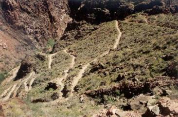
Devil’s Corkscrew
I arrived at Indian Garden Campground (mile 42) at 12:30, just 30 minutes behind schedule. This was the first time I stopped since the bottom, and I only stopped long enough to fill up my water bottle. I was determined to finish strong. I passed many day-hikers heading both up and down. I knew I looked like a mess, covered with mud, and looked very out of place with the other hikers.
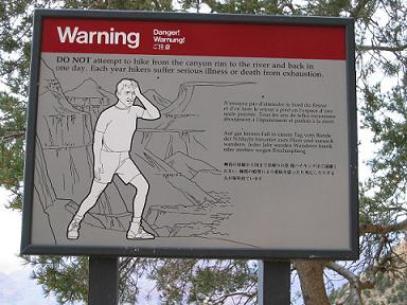
Sign near Indian Garden Campground
warning day hikers to not attempt rim-to-river hikes in one day
I arrived at the 3-mile rest house (mile 43.6, 3 miles from the top) at 13:08, only 8 minutes behind schedule! I was cruising. Finally, reality started to set in as I reached the steepest part of the journey. A young, strong day-hiker cruised passed me, the first person to pass me all day. I started to have some slower stretches, but somehow was able to again fire up the power-hike engine and even run some mild uphills. People I passed noticed that I looked hammered, so I started to talk to them. I would explain that I had been to the North Rim and back. They were all astonished. In one day? How could that be? How many miles? It was good for the ego and sometimes I would break into a run as I left them behind.
I arrived at the 1.5 mile rest house (mile 45.1) at 13:50, only 5 minutes behind schedule. Could I reach my goal of 14.5 hours? The end was in sight but my legs finally started to rebel. They wanted to quit and I slowed to a crawl during the last mile. The trail was very crowded with many tourists going a little way down the trail and then turning back. Some would comment that I looked tired. Little did they know.
Finally, the end was in sight! I finished the last 100 yards strong and let out a cheer when I reached to top. I arrived at the Bright Angel Trailhead (mile 46.6) at 14:43, just 13 minutes off my goal. I gazed across the massive canyon to the North Rim. I had achieved my goal. Including my side trips/wrong turns, I had traveled about 48 miles. My trip down and up the South Rim took about 6 hours and my trip up and down the North rim took about 9 hours.
I devoured food and took inventory of how I felt. I basically felt about the same I did after an average mountain 50-mile race. I felt much better than I did after the tough Zane Grey 50 two weeks ago.
View at the end of my journey
Pingback: Running The Grand Canyon: Rim To Rim | Ultra Running
Great story! thx for sharing this journey and congrats on achieving your goal