

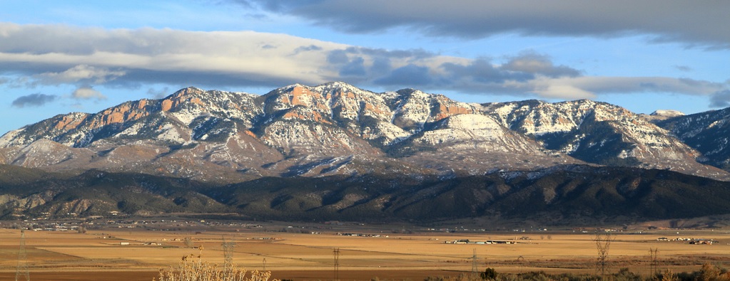
The Sanpitch Mountain Range is just south of the Wasatch Mountains. Perhaps you have looked over to these mountains as your drive south on I-15 between Nephi and Scipio. I’ve looked up there wondering if you could run along the top of them. The Sanpitch Range is about 40 miles long and its highest point is Salt Creek Peak (9,997 feet). The range was named after an Indian leader, who was the leader of the Sanpits that resided in Sanpete Valley during the mid-1800s.
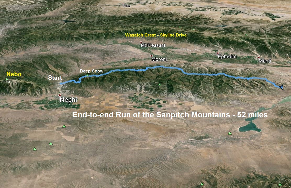
After an adventure exploring the Sanpitch three weeks earlier, I became determined to attempt to run the mountain range end to end, a run of more than 50 miles. There wasn’t much information online about the mountain range top, which is mostly just visited by hunters and ATVers. I planned out my route using topographic maps and hoped that the trails and roads still existed.
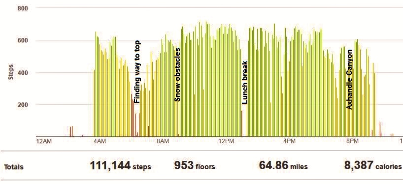
My starting point was on the north end, about three miles up Salt Creek Canyon east of Nephi. This is the canyon at the foot of Mount Nebo. I began my adventure at 3:40 a.m. Immediately I was faced with the unexpected. There was no bridge over Salt Creek. I cast my light around hoping that I missed it, and then groaned and waded through the cold water.
I began my run to the south running up Rocky Ridge Canyon. The road through the canyon was indeed rocky. The topo map showed a trail to steeply climb up Rocky Ridge to the top, but either I missed it, or it is long gone. I found another trail that I thought would connect to it, but that faded away and I returned to the road. I would go with my alternative, to just get up using road 154. I could see brilliant views of the lights of Nephi to the west as I ran along. I used the North Star above to convince me that I was heading in the right direction.
My road ended, as expected and turned into a trail that looked like it now is only used by deer. Dawn arrived as I climbed up a ridge on the trail underneath the Red Cliffs. Trail 154 faded away. Even if I could find it, it would traverse under the cliffs through snow patches and I knew that I would lose it continually. So, my only hope to continue this adventure was to somehow climb to the top of the high ridge above the Red Cliffs, where I knew would be a road to run on.
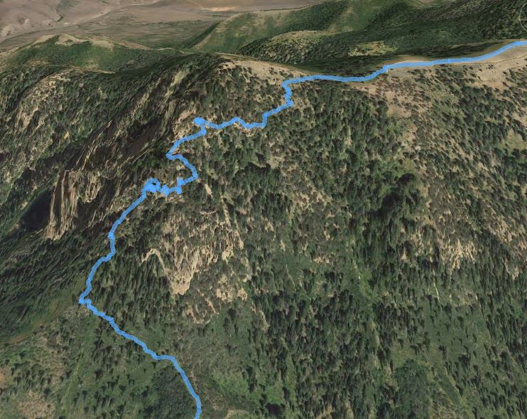
The next hour was rough trying to find a way up to the ridge top. A couple times, I almost gave up, not wanting to attempt anything dangerous. Thankfully I brought my microspikes. I put those on and they greatly helped me get across a steep icy slope to continue. I backed off of a couple rock climbs to the top and instead traversed around several times and eventually found my way up. But it wasn’t the top and I had more climbs ahead.
Finally, after a total of 3.5 hours and only traveling 6.5 miles so far, I reached 9,300 feet and the road on top. My spirits improved and my stress went away. It was a beautiful morning on top and I hoped that I could start making better time.
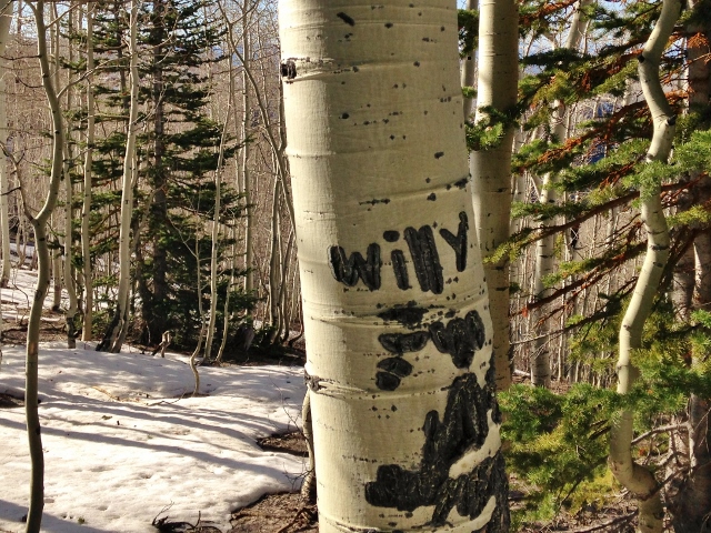
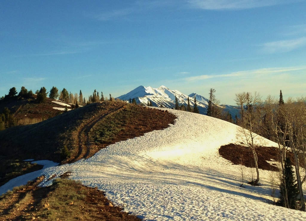
But my challenges continued because of the deep snow above 9,000 feet on north and east slopes. The road was nice when it was bare, but it would quickly disappear under the snow and it was a route finding exercise to try to continue following it. When I went through aspen trees, the carvings on the trees would help me recognize that I was still on the road route. Along the way were some fresh enormous moose tracks in the snow, going the direction I was heading. I never saw the moose and the tracks eventually left my route.
The going was slow. At one point my right leg sank all the way to my knee, causing bad twisting pain. There was no real damage done, but this would be another factor to slow me down. My highest point on my route was at 9,750 feet passing near Salt Creek Peak. After five slow hours, I reached the 10-mile mark at the top of Gardners Fork.
My pace had been discouraging slow, but as I descended to 9,200 feet, the road was easier to follow as it became Skyline trail. Still in my microspikes, I started to clock faster miles, 15, 14, 13, and even an 11-minute mile on a downhill portion.
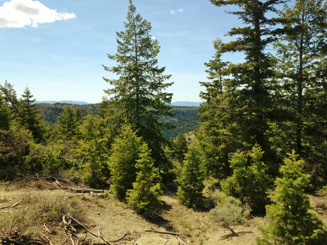
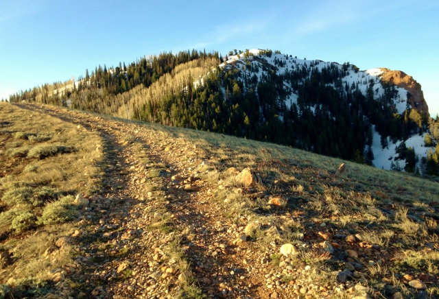
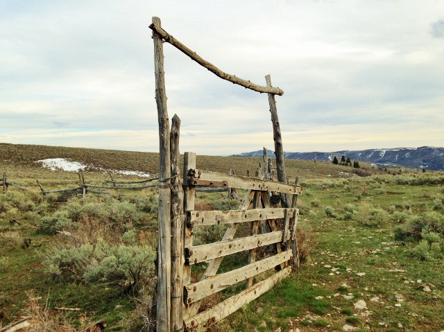
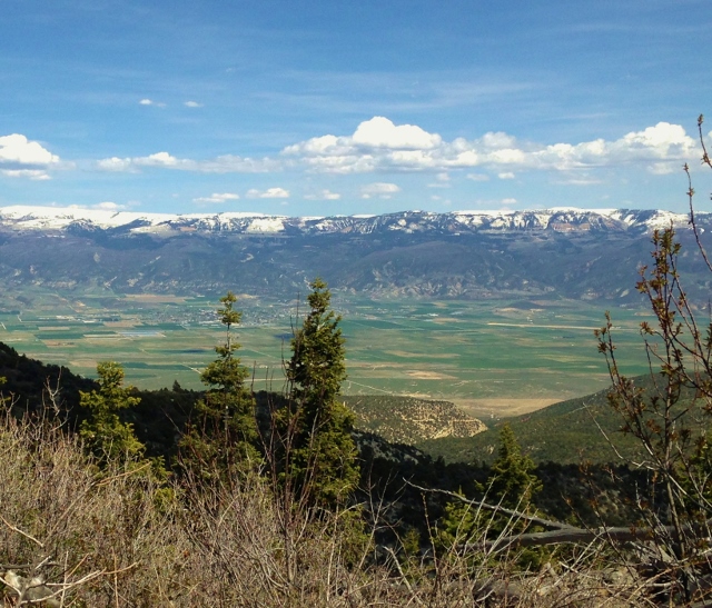
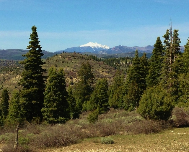
The views were incredible. I ran through pine forests, aspen groves, and wind swept plateaus without trees. My goal was to reach a corral at mile 22 before noon. I had visited that corral last month. I reached my goal and saw my first of four humans for the day, an older couple riding an ATV with their dog running ahead of them. For the next few miles I ran on familiar roads from last month.
I had concerns about obtaining water up on these high ridges, but as I looked further south, I could still see snow patches far ahead. As long as I was above 8,000 feet, snow patches could be found. I continually stopped to pack my water bottles with snow. The early afternoon was warm, so the snow melted fast in my bottles. At the 28-mile mark, at 9:20 into my run, I stopped at a snow patch for lunch. I packed my camelback and handheld water bottles with snow and did my best to eat and drink. My stop was 18-minutes long and a well-needed rest. It was now past 1:30 p.m. and I was concerned that I wouldn’t finish my adventure before sunset. I needed to push the pace.
My route winded back and forth at the top of the range but finally it started to head mostly south. My sense of direction was good, using the shadow of the sun to convince me that I was on the right road, heading in the right direction. I didn’t use a GPS to guide me, instead I had a list of written waypoints, distance, elevation, and description to make the correct turns.
I entered a wildlife protection area, marked with private property signs. It was unclear if the road itself was private, so I just continued on. I never saw anyone and traveled quietly to not disturb any of the wildlife. I ran near Big Baldy at about mile 37, doing another climb up into the snow to 8,500 feet.
Finally I started to descend as I came closer to the south end of the mountain range. I ran a nice fast descent of 1,000 feet in two miles to an open valley at the top of Hells Kitchen Canyon. I was now on a well-maintained dirt road. All the side trails and roads were marked as private property with No Trespassing. I stopped at a spring and filled my bottles for the last time, and filled my stomach as full as possible with water. I was at mile 40 at the 13-hour mark, getting close to 5:00 p.m.
The road took me up one last 300-foot climb, to 7,700 feet. At the point, somehow I left my intended route. I think I had a mistake in my waypoints. Also, the newer dirt road I was on probably replaced an older road. I quickly knew that things appeared wrong, but I was heading due south, so I continued on. But I was confused because it looked like the main road would head east and dump me out into Sanpete Valley.
Since I was basically in the foothills of the range at 7,100 feet, and running out of time, I decided to start heading west on a side double-track road that took me down a pretty canyon. But in less than a mile the road ended at a corral. I could head back or continue on down the canyon without a road. I decided to continue on.
Now my true adventure really started. I first followed a deer trail up on the bank above the canyon bottom but that was slow going and frustrating in the brush, so I decided to jump down into the bottom and hike along the winding bottom that was relatively clear. I didn’t know what canyon I was in. I hoped that it would join another canyon with a road, but it never did. I was in Axhandle Canyon. There was no evidence that a human had passed through it, a concerning sign.
The winding dry gorge looked like a habitat for plenty of wildlife so I took off my headphones to make sure I listened for any snakes. Soon, a cat appeared ahead, a bobcat that took one look at me and quickly ran away. Then I came upon piles of bones, probably an earlier feast for the cat. I later passed by a shallow cave that sure looked like the home of a beast. As I came through a rocky section, my fears were confirmed, a huge rattlesnake was rattling about ten feet ahead of me. I stopped, backed off, and considered how I could pass. I eventually climbed up some rocks and found my way around.
That spooked me. This was not the place to get a snake bite. I was deep in a very remote canyon, no cell signal, moving slowly and no one would think to find me here. The canyon bottom hit a spill-off, so I climbed up the north slope and hoped that moving along the ridge top might be faster. But soon, I heard rattling, just two feet away from me. I jumped away fast. My ridge idea failed as I reached a junction of canyons forcing me to descend back to the bottom on steep loose slopes.
So, it was back to following the canyon bottom. As more canyons joined, the bottom widened for a while into a wash. Looking ahead I hoped that it would soon open up into the wide Sevier Valley, but it didn’t. Instead it became a very narrow gorge. I moved slowing, keeping a keen lookout for snakes. My gorge became a slot canyon and then steep spill offs appeared ahead. It would be impossible to continue on.
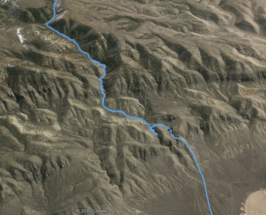
I groaned again. I had been in this canyon for nearly 90 minutes and had progressed only three miles. It was frustrating. I was getting dehydrated and nearly out of water. It was 7:30 p.m. and the evening light was getting fainter. I needed to get out. I backtracked until I came to a point where I could climb up the south slope. At the top of the ridge, I was relieved. The ridge could take me out in Sevier Valley near the little town of Fayette.
It felt nice to finally run again, but I was dehydrated, sipping on my remaining water in my camelback. A cell signal arrived and I called my wife, asking for a ride back to my car. She kindly agreed to come and get me. I knew that it would take her nearly two hours. My three miles in the narrow canyon left me with hundreds of scratches on the legs and dozens of thorns in the hands.
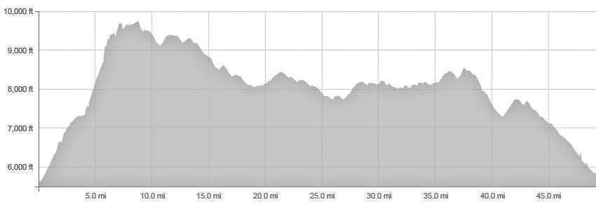
I reached Highway 28 near dusk. I tried to hitch a ride north, but gave up after four of the few vehicles heading that way just drove on. I would wait. My adventure was complete. I did it! I traveled to tops of the Sanpitch Mountain Range for 52 miles in about 16:30. I climbed about 8,300 feet along the way, through snow, mud and by snake dens. It had been an amazing, tough adventure. Now I know the route and next time can make much better time.
Great Adventure!
I really enjoyed reading it.
This could be a very great experience! Sanpitch Mountain is such a beautiful place to see, and running from its one end to another will surely make the visit better.