

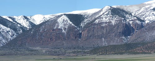
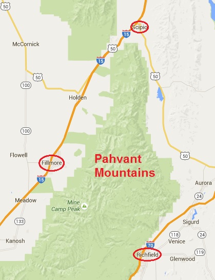
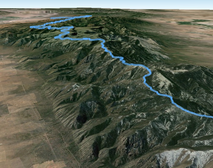
For years as I would drive to and from Captitol Reef National Park to run, I would gaze up at a particular mountain range after passing the small town of Scipio, Utah. This range presents a peculiar flat horizon on top and I would wonder and dream of running along the top of that mountain range end to end, from Scipio to Richfield. Only recently did I learn that the name of this range is the Pahvant Mountains, named after the Pahvant tribe, a branch of the Ute Indians. The Pahvant Range merges into the Tushar Mountains on the south.
The Pahvants are rarely visited, mostly by hunters, ATV riders, and horseback riders. A section of The Pauite ATV trail runs along the southern portion of the range, connecting with the Tushar Mountains. The range is about 44 miles long and 10 miles across. There are a number of peaks along the range over 10,000 feet high.
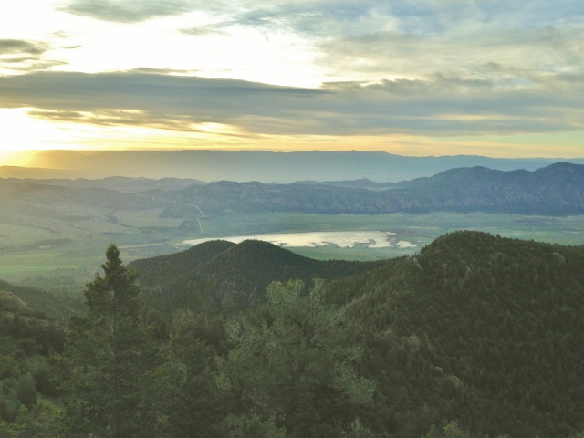
In 2009, an ancient high-altitude Indian village site, named Pharo Heights, was discovered on the range top at 9,465 feet. The village was occupied between years 450-1300 A.D. It was likely a summer residence when the ridge was snow-free. My planned route would take me right by this site. Another village site exists down on the valley floor to the east where they likely lived during the winter.
Each year as the snow disappears from the mountain tops, there is a window of opportunity for a few weeks when you can run long distances on the high ridges and use the remaining snow patches for water sources. Last year at this time I ran along the top of the Oquirrh Mountains. This year I decided to attempt this run that I had dreamed about for years, to run along the top of the Pahvant Mountains.
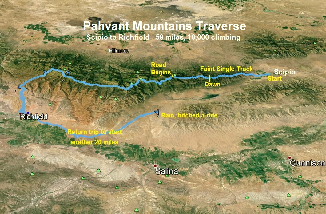
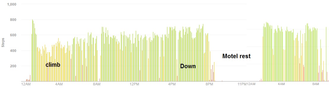
I discovered that there were indeed trails and dirt roads that could take me end-to-end for about 52 miles. I planned my run to start and end from the valley floor at 5,300 feet, Scipio to Richfield, climbing along the way to a high point of 10,023 feet. From Scipio I would run to the foothills, climb steeply along an old faint pack trail to where the main ridgeline begins, connect later with the Scipio Pass trail, and then run along road 096 all the way to Richfield. I then planned to stay the night at a Richfield motel and then run back 38 miles to my car the next day, running through the valley lowlands.
This adventure brought with it some nervousness. I knew that the route would not be dangerously exposed or steep, but it still was on trails I had never run on, and I would accomplish the most difficult part in the dark. I didn’t expect to see any people up there, so if I ran into trouble my ways out would be long descents on rough trails. But my phone would have some coverage nearly the entire way so I felt that the risks were pretty low for this adventure.
I arrived at Scipio after work on Thursday, dropped off some water for my return trip, and scouted out the initial couple miles to the climb up to the ridgeline. The weather for my adventure was warm and windy. The valley floor would reach 95 degrees. Since my first reliable water source, Robins Lake, was at mile 18, I decided to start very early so I wouldn’t need to pack a lot of fluid. I parked my car at a playground in Scipio and began my run at 1:04 a.m. A stiff warm wind pushed against me as I quietly ran south by ranches toward the mountain. I ran without my light on in order to not disturb dogs or people in the tiny town.
I was really glad I had looked carefully at the beginning climb of my run on both 3D Google Earth and on the previous evening because it would have been really hard to get on the route in the dark without this preparation. I first bushwhacked up to a powerline to help me get my bearings. I found the ridge that I would climb and saw only faint outlines of a pack trail that once was used many years ago.
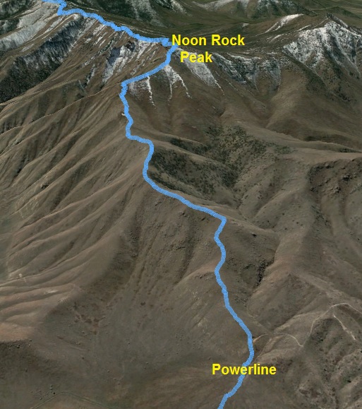
My first section was to climb 2,000 feet in 1.5 miles to Noon Rock Peak. Once on the right ridge, it was easy to stay on track, simply staying right on the ridge. I was glad that I wasn’t climbing it during the day because it looked like a nice habitat for rattlers. A stiff 20 mph wind continued to push against me, but the higher I went, it felt nice and cool.
Looking forward to a warm day, even up high, I dressed in shorts and short sleeves and didn’t bring a jacket or gloves with me. I hauled three water bottles and just enough food, gels, and candy to make it to Richfield.
I reached Noon Rock Peak (mile 4.9) at the 2:13 mark into my run. My pace wasn’t blazing fast in the dark, but was a solid steady climb. From Noon Rock Peak, the faint pack trail was much more distinct along the ridge most the tracks on it indicated it was used mostly by elk. Still very dark, I could see the lights of Scipio behind me and far off 27 miles to the west, the bright lights of Delta.
I was now on the main spine of the mountain range and I quickly learned that if I stayed on the faint pack trail my pace was nearly twice as fast compared to blazing my own route. It became a very fun navigation challenge in the dark to stay on the trail which normally was very close to ridge top, but not right on it. Every ten minutes or so, I would get off track but my skill got better and I could quickly find the trail again. The ridge continued to climb.
At mile 7.8, reaching 8,800 feet, I lost the trail and climbed up to a peak top on the ridge. I got all turned around in the dark, not knowing which direction my ridge continued, but I eventually figured things out and found the trail again. I was 3:36 into my run. Finally the ridge was rolling instead of climbing and I my pace quickened. I really wanted to reach the main dirt road not long after sunrise so I could make much better time. I loved seeing the lights of towns on both sides of me, knowing that I was indeed on the spine of the mountain range.
The sky started to brighten up and a color-filled sunrise cast red against the clouds. I turned off my light at about 5:30 a.m. at about the ten-mile mark. It took me 4.5 hours to cover just ten miles. At this rate it would take me nearly 24 hours to reach the end, but I knew now with light and a better trail, my pace would really improve. I pushed the speed faster, but didn’t want to lose the trail.
At mile 12, I passed above a beautiful area down to the west named Indian Ranch.
Along the way a couple trails, including the Scipio Pass trail joined my trail up on the ridge. I could now see the tracks of a couple horses who had used the trail within the past week. I also saw trash on the trail for the first time and signs that the trail had been maintained within the past couple years.
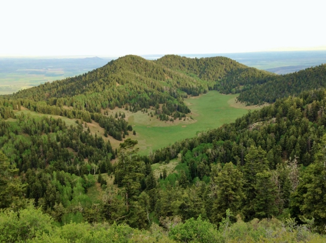
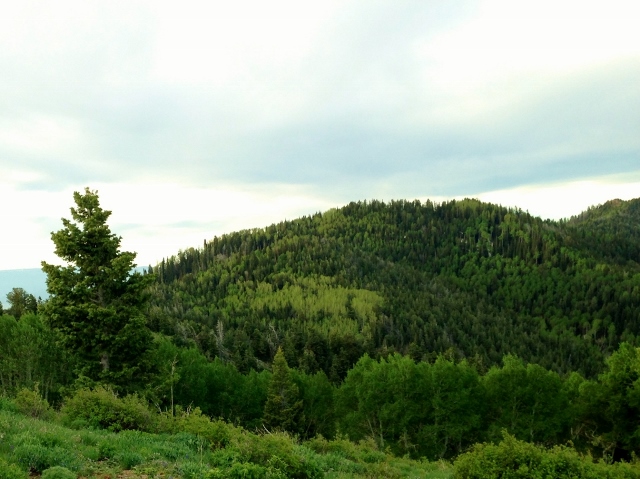
At about 9,000 feet, I was now in beautiful green forest with occasional nice views.
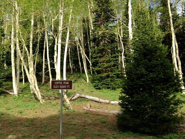
Suddenly, at mile 15.7, at the seven-hour mark, my trail spilled out to a trailhead and a well-maintained dirt road at 9,477 feet, just below Coffee Peak. I had depleted all the food in my pockets and it was time to resupply from my little pack. I took a 20-minute break to rest, eat, and clean my feet, getting the prickly seeds out of my socks from the lowlands.
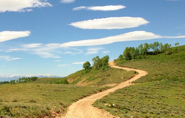
Now on road 096 (which I would stay on all the way to Richfield), my pace was much faster, averaging 12:00-mile pace. My tired climbing legs enjoyed some fast downhills at a much faster pace. But now on this very scenic road, my pace was slowed by sight-seeing and picture taking. I was amazed how green everything was and would see views along that way that would make me stop and gasp.
I passed by Robins Lake (mile 18.8) at the 8:07 mark. I didn’t stop for water because a couple miles earlier I had resupplied my water bottles with quickly melting snow. As long as I was above about 9,200 feet, I could find snow patches all day and didn’t have to take detours down below to find springs.
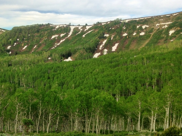
At about mile 19, I began a 1,000-foot climb over the next four miles. I came out of the trees more and was treated by stunning green slopes with lingering snow patches.
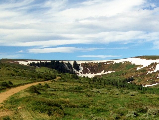
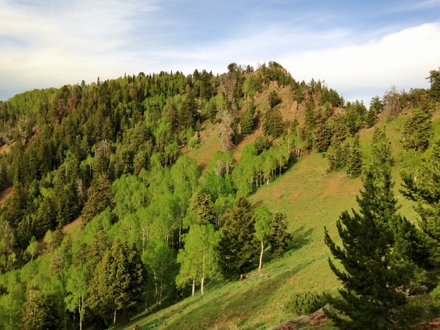
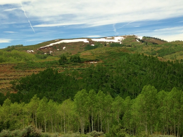
The road climbed higher and higher and I could see that I now was on the high flat top that for years I would gaze up to, wishing I could run there. I was finally there.
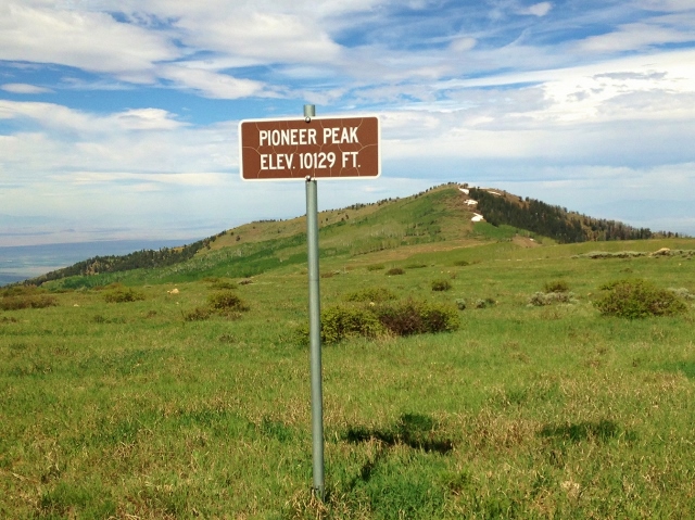
I reached the high point of my adventure, (10,023 feet) on the slope right below the summit of Jacks Peak (10,072). Off to the west was Pioneer Peak (10,129 feet). I was at mile 23.1 at the 9:26 mark into my run. I wasn’t even half way finished yet, but it felt like I had run an entire day.
Now above the tree line, the views all around me were incredible. The day was perfect. The temperature was pleasantly cool up there with blue skies and puffy clouds. I constantly had to stop to take pictures.
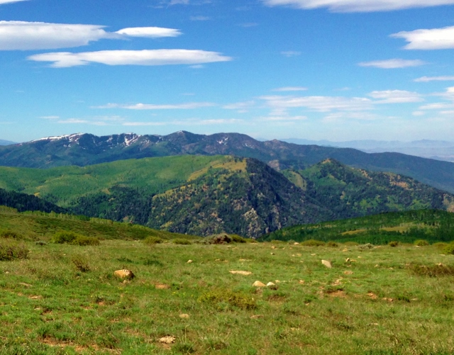
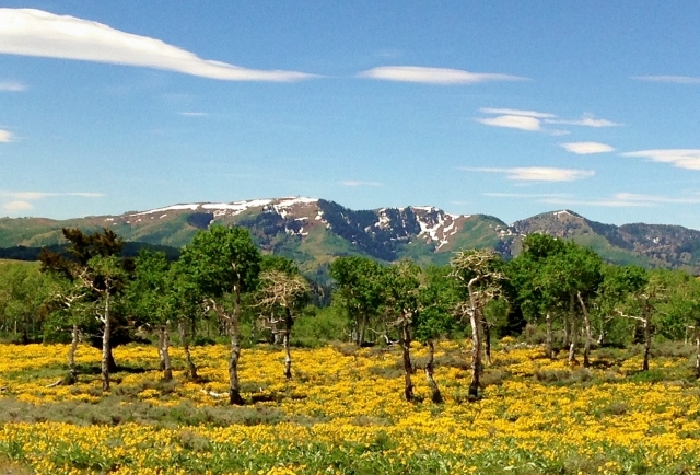
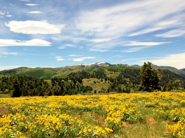
Looking ahead, I could see some snow-splotched ridges that I still needed to reach and off in the distance the snow-covered Tushar Mountains.
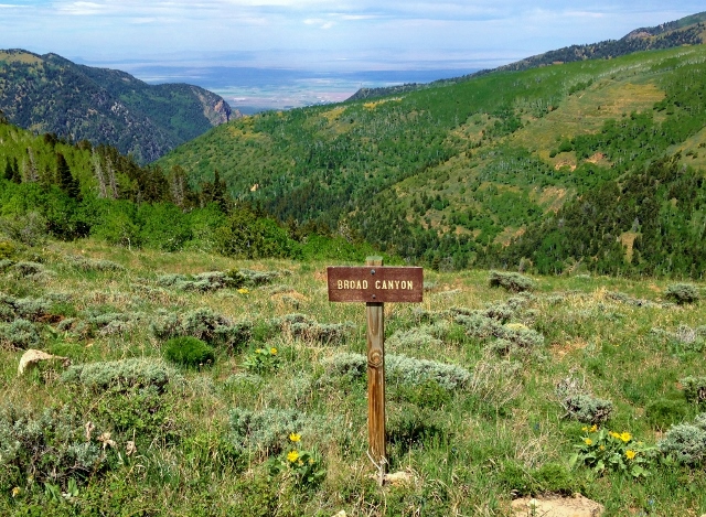
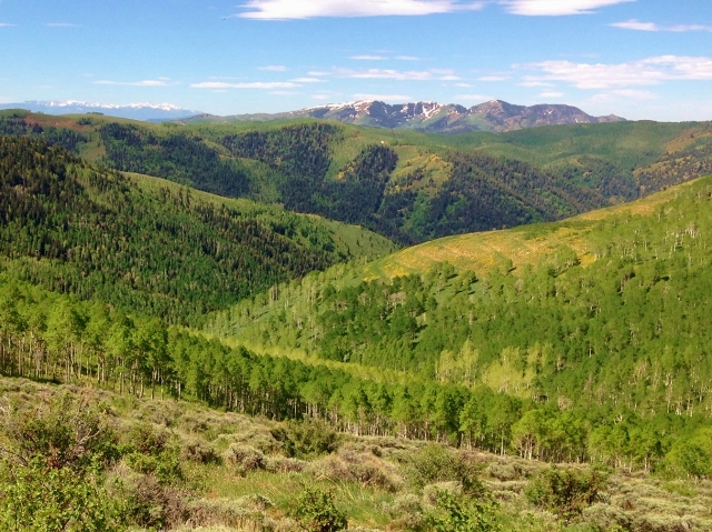
I ran by the tops of many beautiful canyons to the west that would all spill into Chalk Creek, which flows through the city of Fillmore, Utah.
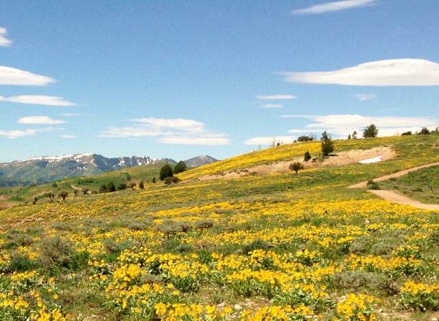
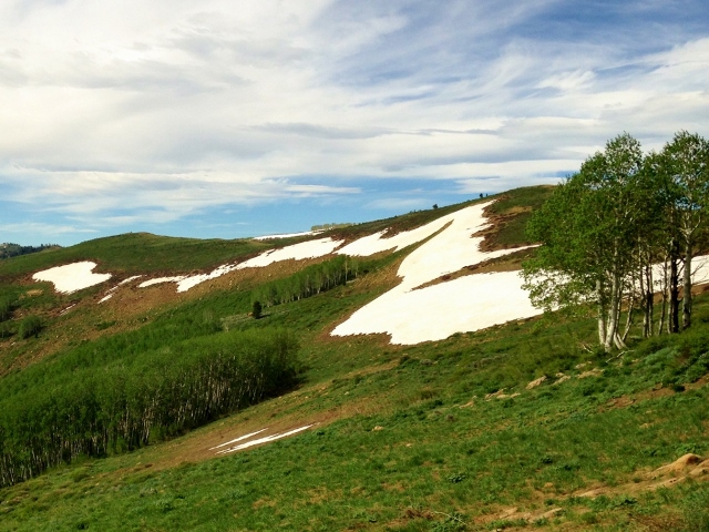
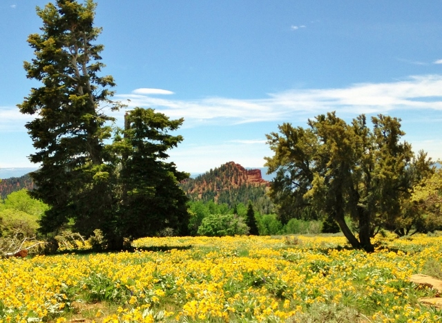
At mile 27.7 at the 10:40 mark, I ran into an explosion of yellow daisies at about 9,300 feet. The contrast of yellow, green, and blue skies were a remarkable sight to see. I thought about my amazing luck to be up there at just the right time when the hills were green and the flowers exploding. I stopped at the snow patch in the above picture to fill up again and drink well. I constantly made sure my bottles nearly full and I was drinking well constantly.
At mile 29 at 11:15, I reached junctions to a nearby spring and the main road down to Fillmore. I had originally planned to run out to the spring, but my water bottles were already full of melted snow. I loved looking at the aspen trees on the ridge lines and at the Tushars ahead to the south.
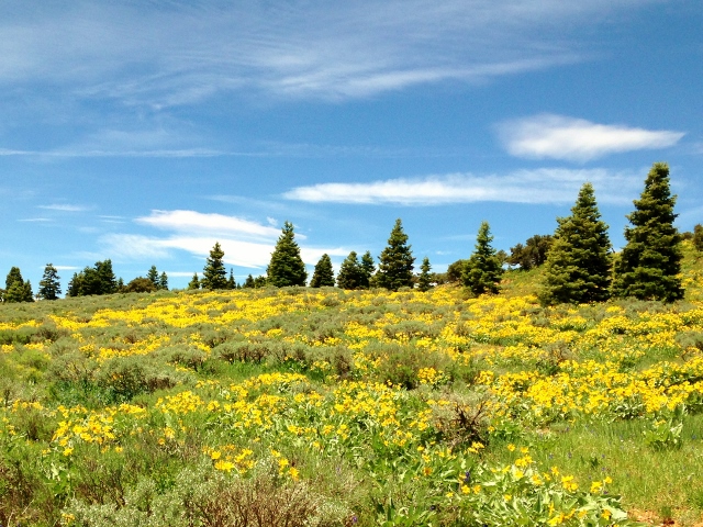
I again entered areas of exploding wildflowers. Wow! I concluded that this had turned out to be one of the most beautiful runs I had ever run, on a mountain range few runners had experienced.
To the east, red hills above Richfield started to appear and I stopped just to gape at the contrasting colors, blue, red, green, and yellow. The different shades of green from the pines and aspens were astonishing.
After having that mountain range all to myself all morning, I was surprised to hear the bothersome noise of an ATV coming from behind me. It contained two older couples who were out for a flower-gazing picnic. I would see them on and off for the next ten miles.
The flower show came to its end at noon as my road descended below 9,100 feet near mile 30.
The ridge descended to 8,500 feet and instead of an abundance of yellow flowers, the slopes presented beautiful green colors. It was warmer down lower and I needed to find Superior Spring to fill up on water. I took a side road that I thought went to it, but instead went to a grove where I found some large water jugs under a shaded tree. I filled up and took a rest to east some lunch. Feeling better, I continued on and soon saw the two couples and their ATV lunching in some shade.
At mile 34, I started my final big climb of 1,200 feet over the next seven miles to reach 9,700 feet again. I would pass by Hans Ridge which I had seen in the distance for many miles. I was glad that I was going back up because it was cooler and I knew that I had snow for fluids.
I reached the top at about mile 41. My route would now head east to descend over the next fifteen miles to Richfield. I was at 14:15 into my journey. Before leaving the highlands, I carefully filled my three bottles and drank as much as I could. I knew that the long downhill during the afternoon would get very hot.
Yes, it became hot. The road down really annoyed me because instead of following a given canyon it would zig-zag between canyons going up and down as if it couldn’t decide when it really wanted to head east down to Richfield. The city came into view just about three miles away, but the road still had about seven miles more.
I knew I would run out of water and started to ration it. I did cross a little creek but didn’t want to dip into it with no filter because I saw that it drained out of a cow pond. I slowed down during the final miles hoping that the sun would descend faster and get things cooler. I really didn’t want to finish off in 90 degree temperatures.
People started to appear with a few miles to go with their ATVs. I was ready to finish. I had eaten the last of my food and just had a little water left. Finally I arrived at Richfield, crossed under I-70, and went into town. I came upon a park with a water fountain and faucet. I was thrilled. I drank and drank and splashed the cool water all over me, cleaning off much of the dirt covering me. I quickly recovered from my mild dehydration and then mostly walked another mile to my motel. Over the next hour I probably drank about a gallon of fluids.
I did it! I traversed the Pahvant Mountain Range! My journey had covered nearly 58 miles and took me about 18 hours. I climbed about 10,000 feet along the way so it was a pretty difficult high-altitude 50+-miler.
After checking into the motel, I quickly went to get food and drink for the night and my return trip. I showered, washed and dried my clothes, ate and drank, and rested as I watched the NBA Finals. Sleep just wouldn’t come, or not for very long. At about 1:00 a.m. I got up and decided to start my return run. I started at 1:52 a.m.
The first seven miles were along Piute Canal which ran closely to I-70. It was fun to run some flat miles and rile up some dogs that saw my green light far in the distance. My legs were still pretty tired but I managed to cover the seven miles in about 1:50. I could see a series of bright lights miles away that I was running toward. It turned out to be a large dairy operation near Siguard. The canal road I was running took my right through the ranch. Because everything was lit up so brightly, I ran with my light off, not wanting to bring any attention to me. But I only saw cows, at a ton of them. As I ran by their huge pen, several saw me and followed me, thinking I was going to feed them. Bales and bales of hay was stored on the other side of the canal. After the dairy I ran by a large car wrecking yard and then left the area and started to climb the foothills to the northwest.
My struggles started during the 1,000-foot climb over two miles as dawn arrived. It was still warm during the early morning and my three water bottles needed to last for 20 miles to reach the point where I dropped off water. I was going through the fluids fast and wasn’t eating enough. I felt a low-energy bonk coming and my pace slowed way down. At the 14.7-mile mark after a slow five hours, I reached the highpoint at a pass at 6,300. Because I was going so slowly, drowsiness attacked me. Over the past 48 hours, I had only slept for about three hours. I finally had to stop lie down. Sleep came for a few minutes and that was all I needed.
I next ran downhill into beautiful Round Valley that seemed to only receive cattle visitors. I came across a spring with pipes that fed into a cattle trough, but I wasn’t low enough in water to consider drinking out of the trough so I continued on.
The morning cooled nicely as a cold front came through. I enjoyed the beautiful morning run through the valley, but I was anxious to reach my water drop near the highway. I kept looking up at the Pahvant Mountains, recognizing points that I had been running on the day before.
Finally, after a slow 6.5 hours, I reached my water cache after running 20 miles. It was so good to drink as much as I wanted. I packed up and started to dread the final 18 miles of road running. I had thoughts about trying to hitch a ride to Scipio and as rain drops started to fall from the sky, my decision was made. But who wants to pick up a dirty stinking old man? Few cars came by and many of them swiched lanes to get away from me as they passed. I would give up, start running, but then try again. Once the rain started to really fall, I decided to be determined and get the hitch. Finally a guy coming back from Capitol Reef took pity on me and picked me up. Twenty minutes later my excursion was over in pouring rain at my car. I’m so glad I started my return run as early as I did or I would have been soaked out in Round Valley without any rain gear. My timing was perfect.
My journey was finished with about 78 miles. I’m sure I will return to run the Pahvants again. There are many canyons and trails yet to explore. This makes ten weeks in a row of doing at least a 31-mile (50K) run.
Next up: Bryce 100 in six days. This run was excellent last-minute training to spend many hours running at altitude.
I’ve loved looking up at the Pahvants from US50 for almost 35 years now, and always wondered what they were like on top. Your photos are wonderful and your story is amazing. Thanks for taking the time to post this blog.
Be well