

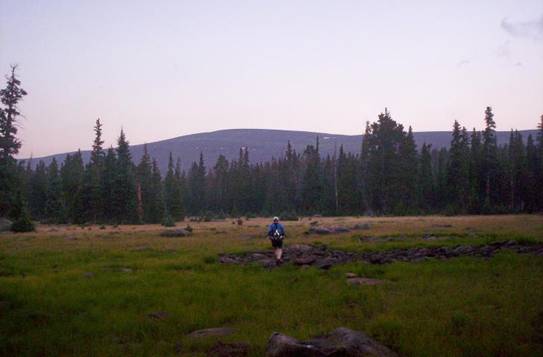
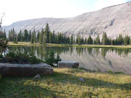
The Uinta mountain range in Utah is one of the few ranges in North America that runs east to west. This mountain range contains all of the Utah peaks higher than 13,000 feet and it is the most remote mountain range in the state. The highest continuous established trail in the Uintas is the Highline Trail (#025) that runs the length of the mountain range. This very remote trail is one of the most remarkable trails in the nation. In its entirety, the trail is more than 100 miles long. A 78-mile stretch from Leidy Peak on the east to Hayden Pass on the west is generally recognized as the end-to-end expanse of the trail. The rest of the trail is through mostly forest outside the wilderness area.
Before going further, I need to recognize the Utah ultrarunning pioneers who have inspired me and others to do distance runs and fastpacking on the Uinta Highline trail. In the late 1970s, a small group of talented athletes started to organize and participate long distance trail runs. These events were small and informal but continued through the 1980s. These characters included runners like Irv Nielsen, John Moellmer, Dana Miller, Jim Knight, Grizz Randall and others.
On September 7, 1979, a “Uinta Primitive Ultra Trail Run” was organized by Jan Cheney on the Uinta Highline Trail. This was a two day 30-mile out and back from Hayden Pass up over Rocky Sea Pass and then to the Black & Brinkley Lake area. Camping gear was hauled in to the lake ahead of time.
In 1988, Jim Knight wrote an article on “fastpacking” that appeared in Ultrarunning Magazine about his historic adventure on the Highline Trail in the Windrivers, in Wyoming. This inspired other ultrarunners to start testing their limits on long adventures in remote areas.
In 1991, John Moellmer and Dana Miller went on an epic fastpacking adventure traversing the entire 105-110 miles of the Highline Trail from Lonetree Campground (on Rt. 191 north of Vernal) to Hayden Pass (near Mirror Lake). Their adventure took 3.5 days and has been a deep inspiration to me and in turn others. You can read about their historic adventure here.
In 1992, others wanted to experience this remote Utah wilderness. A group of eight, started at Leidy Peak and traveled along the Uinta Highline trail to Hayden Pass. Their 3-day 78-mile adventure took 57 hours and 29 minutes with an actual running time of 35 hours and 30 minutes. Read their story here.
In September, 2003, before I had ever heard anything about ultrarunning, I read about John and Dana’s 1991 adventure on the Highline Trail. I had been doing some fastpacking, felt very confident in my abilities, and decided to give it a try. I boldly went to Chepeta Lake and set off on the Highline Trail believing that I could cover the 65 miles to Hayden Pass in about 30 hours. I was ill-prepared and inexperienced. I ended up doing an out-and-back to Tungsten Pass covering about 60 miles in about 48 hours. This included hiking six hours in pouring rain. On the way back a snowstorm halted my efforts near North Pole Pass and I had to set up my tent for the night and wait for morning. I wrote in my journal, “Well, I think I’ve cured my power-hiking addiction this past weekend. I don’t feel the itch to get back out there soon.”
It took four years, but I returned in 2007, now an experienced ultrarunner. I guided Matt Watts on the same attempt, Chepteta Lake to Hayden Pass, about 65 miles. We were successful. We didn’t stop for the night, kept pushing ahead, and eventually finished in 29 hours and 44 minutes, believed to be a speed record time for this stretch of the Highline Trail. Brian Beckstead attempted the same adventure, solo, later that same month. He completed it, but was delayed several times by severe thunderstorms. He finished in 31:59. Since writing up these adventures, others have been inspired to fastpack the trail, but it appears that the record time has stood for three years.

I was ready to return and this time up the ante, go further, faster, and do it solo. I decided to start at Leidy Peak, the starting location of the 1992 expedition. I felt confident that with my experience on the trail, I believed I could cover the 78 miles or so in 28-30 hours. This adventure would involve more than 13,000 feet of climbs over more than 8 passes.

I need to caution others about the risks of attempting long distances on the Highline trail.
- This area is very remote. Once you are deep on the trail, you are usually 20 miles or more from any trailhead. There is no easy way out, no road crossings except at Chepeta Lake. Seeing other people on the trail except near Kings Peak can be rare.
- Thunderstorms can be fierce in those mountains from August-September. People have been struck by lightning in the Uintas.
- The trail is difficult to follow in places and there are not always signs at intersections. Maps are needed and GPS use is very helpful. Every year people get lost for a day or more in these high mountains.
- The weather can change on a dime. The high temperature is normally in the 60s and the low during the night can dip into the 30s or lower. Hypothermia is a danger.
- Navigation during the night on the trail can be nearly impossible without a map/compass or GPS with waypoints. Most fastpackers/runners on the trail stop for the night.
- The trail can be very wet. Keeping your feet dry is pretty much impossible. Count on plenty of creek crossing, marsh crossings, and mud bogs. In most places the Uintas can be a giant rock pile. The rocky trail can be very tough on your feet.

For my run, I believe I prepared well. I studied the route carefully and programmed more than 150 way points into my GPS. For the sections that I would be on during the night, I put in additional waypoints because I knew I would lose the trail. My emergency gear included a SPOT transmitter to broadcast my location to friends and serve as an emergency locator if needed. I also brought an emergency blanket, flint and steel, whistle, and rain gear. I opted not to take a sleeping bag or tent. It looked like I would hit some thunderstorms. I planned to just huddle in my rain gear to stay warm if I had to wait out a storm.
I traveled very light. I carried enough food to make the trip but not much more: Gels, burritos/hot pockets, candy, beef jerky, and Instant Breakfast. I only brought one hand-held water bottle, planning to just dip it into passing creeks as I went without filtering, but avoiding steams in the lower valleys that might have sheep in the area. My pack felt light, probably no more than seven pounds.
I arrived at the Leidy Peak trailhead, northwest of Vernal, Utah, above Hacking Lake, on Thursday evening. The area was soaked from rain earlier in the day. There was only one other car at the trailhead and I immediately had a very isolated and lonely feeling come upon me. I set up my tent with a chair inside and did me preparations before trying to get some sleep. I only slept a couple hours and at about 2:30 a.m. decided to just pack up, and get in the warm car to get all ready to go.
At about 4:20 a.m., I was finally on my way in the dark. Within 100 feet I lost the trail. “Great, way to start,” I thought. I pulled out the GPS and got oriented. Finally I figured things out and noticed some signs marking trail “025” which I remembered was the number for the Highline Trail. Leidy Peak was high above me to the right which I could see clearly because of the bright half moon out. I quickly realized that navigation would be very challenging and I concentrated on staying on the trail and honing my skills to find the right route. But soon I had to make a decision. The “025” trail branched away from Leidy Peak. I remembered that in 1995 they relocated many sections of the Highline Trail in this eastern section. However, in my GPS I had waypoints from the old trail which is still shown on the topographical maps. What should I do? I decided to stick with the old trail. If I followed the new trail and lost it, my GPS couldn’t help me at all. On the old trail it could.
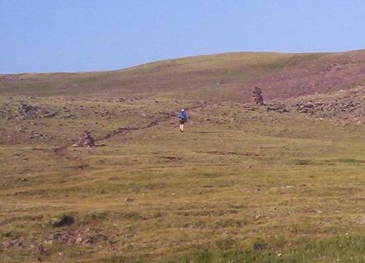
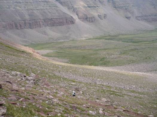
Using my GPS I navigated back to the old trail which was very faint but I knew it went around Leidy Peak. I soon understood why the trail had been located. The old section was very rugged and hit areas where boulders covered the slopes. My progress was pretty slow but I trusted the GPS and just did my best to find the right route. Eventually I arrived at a wide-open, grassy slope and it didn’t matter where I ran. I had my GPS in one hand, my flashlight in the other, and made my way up to an unnamed pass. Finally I connected with the trail again and descended down toward Lake Wilde making very good time, enjoying bounding down grassy slopes very fast.

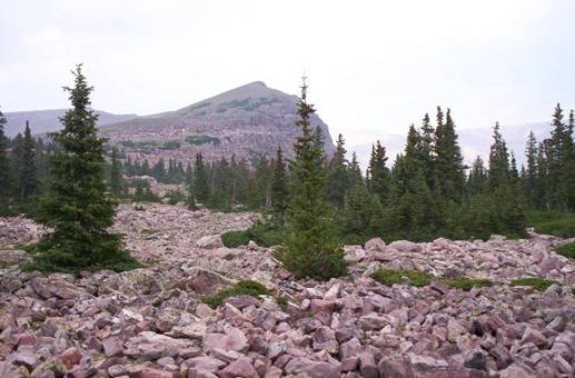
It happened again. Trail “025” went off in a new direction. I studied a slope above me and could see the old trail ascending to Gabbro Pass. So, again I stayed with the sure thing. A little below the pass, the trail was covered with a massive snow field that was too steep to try to cross. I climbed straight up the slope and found an easier way across the snow and soon arrived at the top of Gabbro Pass at 11,600 feet. This was at mile 5.1 and 2:04 into my run. I was already 34 minutes behind my planned schedule. At least it was light now and I could run at a better pace.

I stopped to pull out my SPOT device to send an “OK” message that would send an email and plot my location on a Google Map online for my friends to see. I planned to do this at every major pass. This turned out to be a waste of time, only one such signal went through because it takes about ten minutes to send and I only waited about 5-6 minutes. (I would end up wasting about an hour total playing with that device.)
My feet were sopping wet. Because of the previous day’s rain and the night’s heavy dew, when I ran through grasses, within seconds it felt like I had stepped in a creek. The trail was far wetter and muddier than my run in 2007. This made it much slower and difficult.

I continued on running far above the tree line. The morning views of the tree-covered basins below were incredible. I descended down toward Deadman Lake, a depressing name to think of being so far away from anyone else. The lake looked so calm and peaceful. The trail branched and I again found myself on a relocated section of “025” that looked like it was going to head down the valley taking a wide detour. So it was again time to go cross-country to link back up with the old trail. This involved a tough boulder scramble up to the next unamed pass above Whiterocks Lake.

As I descended down the other side toward Whiterocks Lake, the trail became more defined with evidence of horse traffic. I could run at a much better pace and had a blast running through the forest. I arrived at Whiterocks Lake (mile 9.3) at 3:36, only 21 minutes behind schedule.
The long section between Whiterocks Lake and Chepata Lake was rolling forest and meadow running. Why was my pace generally slow? The reason was obstacles. There are sections were I could really run fast, but it never failed. . . very soon I would come to a halt because of a creek crossing, a mud bog, a marsh, or a boulder filled trail. It seemed impossible to get into a good running rhythm because it was always start, stop, start, stop.
Finally I was coming close to Chepeta Lake, an area I was familiar with. I had been experiencing feelings of loneliness and it was somewhat comforting to know that I was crossing briefly into an area where I would see other people. I ran up the road to the dam and sure enough saw some trucks with horse trailers parked. I saw a man out by a trailer. I waved but he ignored me so I went on. I arrived at Chepeta Lake (mile 13.4) at 4:46, only 16 minutes behind schedule. This was the point of the Highline Trail where I had started in 2003 and 2007.
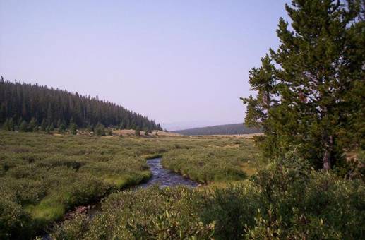
From there, instead of following the new relocated Highline Trail that continues a half mile south of the dam, I decided to follow the old trail that starts on the other side of the dam. I had not been on this section before but enjoyed it far more than the relocated winding forest trail that is difficult to follow. My trail was wonderful as it ran by small beautiful lakes, crossed wide-open grassy meadows and then went through some shady forest. Near Reader Lakes, I connected back with the trail I had been on three times before. There would be no need to consult with the GPS for many miles.
I climbed up above the tree line again and made the tough climb up toward North Pole Pass. This area is fascinating because of the massive cairns (trail markers) made of huge rocks that could be seen towering in the distance. I arrived at North Pole Pass (mile 19.8) at 7:17. My pace had been slowed because of a stop to clean a foot and fix a hot spot. I was 37 minutes behind but confident with the downhill ahead that I could make up some good time. Well I tried, but the trail was so rugged.

For the next several hours I made my way across meadows and through forests staying down in the valleys. I experience lonely feelings, wondering if my family was OK, and trying not to think about what was going on at work. The stress of being alone at times bothered me and I questioned whether I was doing the right thing being so far away from others.

I arrived at Fox Lake (mile 22.8) at 8:13, 33 minutes behind schedule but pleased that I was still going at a good pace.
It was now afternoon and the clouds were rolling in. Soon light rain began to fall but it wasn’t enough to really get me wet. As I was running through the forest, I was surprised to see a guy in rain gear sitting beside the trail. He had a shovel next to him, so I knew he was a Forest Service employee. I stopped to chat for a few minutes. “Are you one of those crazy Highline Trail runners?” he asked. I was surprised by the question but proudly replied that I was. He explained that there had been a few of these runners, the most recent one last week. (I later learned that this runner took two days or more). This Forest Service guy was planning on spending several days in the wilderness visiting several locations to work. He wished me luck and away I went. I arrived at Kidney Lakes junction (mile 27.7) at 9:43, gaining on my schedule, 23 minutes behind.
The next forest section to Painter Basin was long. I could push the pace fast at times, but there were sections of that were slippery on the rocks because of the afternoon rain. At one point it started to rain harder with some thunder booming and I put on my garbage bag. But within minutes it stopped. That turned out to be the worst rain I would experience on the entire adventure, not much.

I soon noticed a terrible problem descend on me – mosquitoes. I foolishly didn’t bring any spray. With the warmer, humid afternoon, they were out in force and very blood-thirsty. As long as I was moving fast and swinging my arms, I was fine, but on the slower uphills they would spot me as fresh meat. It became discouraging. I needed to stop to get some food out of my pack, but as I did, the nasty bugs covered me and I quickly had to get running again without the food out. The hordes became even worse as the trail left the forest and entered the wide-open, beautiful Painter Basin (mile 34.4). I arrived there at 12:17. I kept fleeing from the insects, hoping that as I climbed higher, they would go way. I was getting very tired of slapping myself. But even at 11,300 feet, the blood-suckers were still tormenting me. At least they gave me some motivation to keep moving at a good clip.

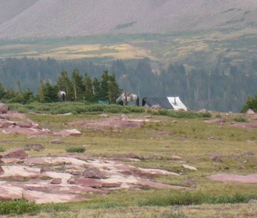
As I climbed up toward Andersen Basin, as expected, I ran into hikers returning from their trips to the top of Kings Peak, the highest mountain in Utah. I ran into three groups, all taking the very long route down through Painters Basin instead of the cutoff that saves miles and an hour to Gunsight Pass. The last group I met was a father with two sons. They were stopped on the trail and looked miserable. The dad explained that his son had been throwing up continually for quite awhile and wasn’t making much progress on the trail any more. He was clearly concerned. I stopped for several minutes and talked things through with the dad. I asked about altitude sickness. I asked about salt-intake. The dad was clueless about electrolytes and said they had been drinking only water. I explained about salt intake and gave him two Succeed Caps to try to get his son to take. In exchange, they let me use their insect repellent. I was delighted, it immediately helped and boosted my spirits. This group still had miles to go before they returned to their camp and I doubted that they would make it before dark. The dad seemed confident that they would be OK, so I wished them well and bid them goodbye.
My progress climbing up to Andersen Pass, below Kings Peak was very slow. The altitude really was slamming me as I climbed to the high-point of the trail at 12,600 feet. Usually I could get cell coverage at this point, but my Sprint phone couldn’t get a strong enough signal. I was disappointed that I could not call home. I arrived at Andersen Pass (mile 37.4) at 14:00, now 50 minutes behind schedule. I made a long stop and felt discouraged. But I did the right thing and ate a feast to bring myself out of my bonky slowness.
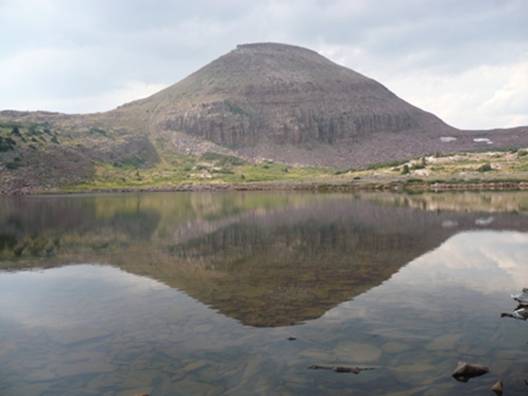
On the other side of the pass is a spectacular view of Yellowstone Basin far below. I think this is probably the most beautiful, scenic location of the trail. Feeling much better I descended the steep trail into the valley, losing more than 2,500 feet. As I reached the grasslands, I left the horse trail and bounded down the grassy slopes. My running gear was working great. I concentrated hard to keep it up.

The trail crosses the massive valley, falls down into the trees and on the other side climbs back above the tree line. As I was starting to climb up the other side, I heard ahead whistling and shouting. It sounded like kids have fun. But when I looked carefully ahead, I could see what looked like a long white fence on the ridge ahead. But the fence was moving! It was fascinating to watch. It turned out to be hundreds of sheep with a lone shepherd on a horse moving them along.
When I reached a point above them, I could look down and watch the shepherd working to bring all the sheep together on a protected bluff, their likely location for the night. Watching the waves of sheep move in the distance was a spectacular sight in the scenic valley below. I knew my pace was good, so I didn’t pause to watch too long. I was also motivated to put in as many as possible before sunset.
I reached Tungsten Pass (mile 42.9) at 15:52 (8: 12 p.m.). Wow, I was only 12 minutes behind schedule! I was thrilled by my progress and wondered if I could reach Porcupine Pass on schedule. The next few miles were grassy hills above the tree line, around Tungsten Lake and North Star Lake. Dusk arrived and as I approached the base of the steep slope up to Porcupine Pass, I could no longer see cairns. I lost the trail and my GPS was not helpful in locating where the trail went up. In addition there was a big snow field all around the base, certainly covering and hiding the trail.
I sat down, ate to gain back strength, and was bummed out that my quest to get back on schedule was foiled. I turned my light on and pushed ahead. I decided to just climb straight up the snow field and the slope above. That worked out and eventually I found the switchbacks of the trail, but it was slow. I reached Porcupine Pass, 12,200 feet, (mile 45.6) at 17:12, losing 15 minutes to my schedule.

Up over the top, I now had a steep, rugged descent on a poor trail and very steep slope, down in the dark into the Oweep Valley. In 2007, it was still light at this point. This time I would have to navigate in the dark. I recalled that Matt and I were able to run swiftly through this wide open grassy valley making good time, but this year it was much more difficult in the dark. The trail faded and I had to keep consulting the GPS to go in the right direction. For miles I was still above the treeline on grassy slopes running downhill, but I didn’t want to go too far off course.
After awhile, I was puzzled why my GPS waypoints were not leading me in a direct course toward the base of Mount Lovenia, where I knew I needed to go. The moon was now out and was illuminating the mountain slopes around me. I thought I knew better than my GPS and decided to skip following a couple way points and take a more direct route. Well, I soon discovered the reason for the detour. There were meadows of thick brush in the way and apparently the trail went around them. I just plodded ahead making rather slow progress in the dark. Soon I joined up with the trail again but then recalled that there weren’t good cairns across massive Lambert meadow. I had to rely on the GPS again. This was frustrating, slow progress in an area that I knew was fast running in the light.
Finally I reached the base of Mount Lovenia, mile at 19:45 (mile 51.9), nearly an hour behind schedule. It was now close to midnight. My slow progress in the dark was discouraging but I pushed ahead. The trail around Mount Lovenia was surprisingly tough.
While I run, I typically spend much of my time thinking about my running strategy, when I should eat/drink, what I should do at my next brief stop, adjustments I need to make, and what is coming up on my route ahead. Once the sun went down, after awhile I noticed that my mind went into an odd semi-dream state, certainly brought on by sleep deprivation.
Instead of just thinking about what should be done, it evolved into a strange conversation within my mind. It was like there were now two individuals involved. One person was physically doing the work and feeling the pain, not doing the thinking. The other person was doing the thinking and making the decisions. Over and over again, I noticed my mind would think things like, “we now need to have him eat something. Yes, that will help him.” “He’s starting to slow down, we need to push him harder.” “His right foot is hurting, he needs to check that out.” It took me awhile to notice these odd conversations going on and it was somewhat freaky but it went on for hours, dozens of times. I kept correcting myself, trying to get my mind to understand that there was just one person involved here, but I finally gave up and just accepted this crazy thinking. It was kind of like my mind was detaching itself from the physical effort and pain.
Another odd thing as I would think about the trail sections, for some reason they became associated with people in my dream state. The trail was somehow associated with an individual, not sure why, but as the trail changed, it was associated with a new individual. One time it was a color, I was on the blue trail. Another time I was on a trail associated with an Asian woman. It made no sense, but dreams don’t often make sense.
At another time, I found myself thinking that my friend Matt Watts should be catching up with me soon. This is because I was on a section of trail I ran at night with Matt three years ago. I kept correcting myself, shaking myself out of my dream. No, Matt wasn’t coming, I was on my own.

I pushed up the slopes toward Red Knob Pass, a major pass to get over. I recalled that in 2007, Matt and I just couldn’t find the right way up and ended making a tough scramble toward the top. I followed my GPS waypoints but there was no evidence of a trail. I searched and searched. Eventually, I again just headed straight up. It was very slow going because the altitude slammed me again, but the voices in my head pushed me to the top. I arrived at Red Knob Pass (mile 58.8) at about 23:00, now nearly 90 minutes behind schedule. I no longer cared about finishing with a good time. I was shifting into survival mode to get this done. There was no way to quit. The way out in all directions was about 20 miles.
From the top of the pass, I could clearly see that there was a trail used by horses to get to the top of this pass. I knew that in a couple weeks I would be returning here on a backpacking trip and I look forward to finally figuring out that trail.

The descent was much like the descent down from the other passes, steep switch backs. My legs really appreciated running downhill again. I imagined that the dark valley below with Dead Horse Lake was probably beautiful. I’ve never seen it during the day.

I descended down 1,500 feet quickly and then started the slow tough climb up yet another pass, 1,000 feet above me. Thankfully the trail was very defined. I reached Dead Horse Pass (mile 61.9) at dawn, at 25 hours into my run. During the night, I had only cover 18 miles in the nine hours.
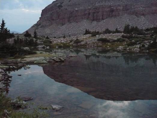
The morning light exploded into my view wonderful scenes of the valleys below. My spirits lifted as I took in the landscape and thought about the nice long downhill run ahead. Here I was deep in the high Uintas, in the most remote mountain location in Utah, viewing a spectacular sunrise. All this effort seemed to be worth it.

I descended down into the next valley and above Ledge Lake made a long stop to clean my feet and tape some problem areas. I thought about the many miles I still had ahead of me and soon went back to work. I made some very good time running in the upper Rock Creek area, but the rugged trail was taking its toll on my feet. They were really aching from the rocky footing. I soon reached the Rock Creek Valley where Matt and I became terribly lost in the dark, in 2007, and spent two grueling hours descending 1,500 feet to the creek bottom. This time I stayed on the trail but it was in terrible shape and hard to navigate even in the light. I was thankful that I wasn’t here again in the dark. Even with more waypoints in my GPS this year, it would have been a very slow frustrating experience. Many times in full sunlight I would need to stop, scratch my mosquito bites, and try to figure out where the trail went next. Then it made a punishing, rough, steep descent through the forest that seemed never ending. This was clearly my least favorite section of the trail.
I reached Rock Creek (mile 67.3) at 27:49. I had hoped to be at this point three hours earlier. My memory of the trail ahead was dim. I think I had just blocked it out of my memory on purpose. It was another huge rugged climb, sometimes just up boulder creek beds. I had to make another 1,000-foot climb that seemed to never end. To make matters worse, the mosquitoes were back at it and my repellent had worn off. I kept long sleeves on to protect me despite the warming morning and kept swatting at the beasts.
Finally I reached the lake below Rocky Sea Pass. I heard behind me voices. A family on four horses soon caught up who had been camping in another valley. I gave a cheerful hello and the leader said that I should just grab on the tail of the horse to pull me up the pass. I wished that I could. The climb up this pass was tough. My energy level was low, my respiration high, but I pushed ahead. I needed to stop for frequent rests, but when I did, the blood-suckers descended on me. Thankfully as I reached the top of the pass the wind picked up and blew the beasts away. I reached Rocky Sea Pass (mile 70.1) at 29:30 (9:50 a.m.). I knew there was just about eight mostly downhill miles to go. At the top of the pass there were four hikers resting. I know I looked like a mess. They looked at me wondering, but I just continued on.
I’ll be truthful. The final eight miles were a death march. I was anxious to finish. Despite my slow pace I passed about a dozen hikers including a group that used three goats to pack in their camping gear. Several people noticed that I was struggling and asked if I was OK. I assured them that I was fine. I had a nice chat with one guy who hikes this trail often. He knew I was a Highline trail runner and commented that he had seen the last one there on Tuesday, but that he had taken more than two days. I hoped to beat 32 hours, but my pace kept slowing to a crawl. Those last 8.4 miles took nearly four hours. With one last short climb, I finally reached my destination, the western portal of the Uinta Highline Trail, Hayden Pass (mile 78.5). I arrived at 33:19. I washed myself up and within a half hour felt much better. I had no transportation at the trailhead and my cell phone had no signal, so I asked the other hikers for a ride, but they were headed in the Wyoming direction. Another group was busy trying to locate a boy who didn’t arrive back with them.
Finally I decided to just go out to the highway and try to hitchhike down the canyon to Kamas where I could call my wife. I eventually got a ride with a couple nice guys who had been running an aid station for the “Tour de Park City” bike race. I had great fun telling them about my adventure. They had never heard about ultrarunning before and kept peppering me with questions. They left me at Kamas where I spent an hour in a burger joint, feasting, recovering, waiting for my ride home. After a wonderful night’s sleep, we spent Sunday making the 10-hour drive to retrieve my car left at the eastern trailhead.
So I did it. I believe I set a speed record on the Uinta Highline Trail for Leidy Peak to Hayden Pass in 33:19:12. I post this claim, not to boast, but to put it up as a goal for others to shoot for. Also, it is to honor the Utah ultrarunning pioneers who paved the way for an accomplishment and experience like this. I would have never done it without their reports and inspiration. Looking at my time, I also broke the known speed record for the Chepeta Lake to Hayden Pass stretch. I covered that in 28:33.
Within a day, the Uinta Highline Trail is calling me back. I have unfinished business. There are still 25 miles or so that is technically part of the Highline trail that I have never run. Those rough 25 miles took John Moellmer and Dana Miller 12 hours to cover in 1991. Something tells me that I should be able to do the entire 105 miles or so in less than 40 hours. I hear it calling for me, or perhaps that is just mosquitoes still buzzing in my ears.
| miles | Split | goal | 2010 | |
| Leidy TH | 0 | 0:00:00 | ||
| Gabbro Pass | 5.1 | 5.1 | 1:30:00 | 2:04 |
| Deadman Lake | 6.6 | 1.5 | 2:15:00 | 2:36 |
| Whiterocks Lake | 9.3 | 2.7 | 3:15:00 | 3:36 |
| Chepeta Lake | 13.4 | 4.1 | 4:30:00 | 4:46 |
| North Pole Pass | 19.8 | 6.4 | 6:40:00 | 7:17 |
| Fox Lake | 22.8 | 3 | 7:40:00 | 8:13 |
| Kidney Lakes | 27.7 | 4.9 | 9:20:00 | 9:43 |
| Painter Basin | 34.4 | 6.7 | 12:00:00 | 12:17 |
| Andersen Pass | 37.4 | 3 | 13:10:00 | 14:00 |
| Tungsten Pass | 42.9 | 5.5 | 15:40:00 | 15:52 |
| Porcupine Pass | 45.6 | 2.7 | 16:50:00 | 17:12 |
| Mt. Lovenia | 51.9 | 6.3 | 18:50:00 | 19:45 |
| Red Knob Pass | 58.8 | 6.9 | 21:20:00 | 23:00 |
| Dead Horse Pass | 61.9 | 3.1 | 22:50:00 | 25:00:00 |
| Rock Creek | 67.3 | 5.4 | 24:30:00 | 27:49:00 |
| Rocky Sea Pass | 70.1 | 2.8 | 25:30:00 | 29:30:00 |
| Hayden Pass | 78.5 | 8.4 | 28:30:00 | 33:19:12 |
All I can say to this is, Wow! You have some guts and courage and determination.
This is one of your more well-written reports. It is striking, to say the least. Thank you for sharing that and for being daring enough to take on such an amazing challenge. I hope one day I’ll be good enough to join you on such an adventure. I seem to have a similar draw and passion for the Uintas. They are beautiful and remote and possess an allure like few places I have ever been.
Thank you again. This was a truly inspiring report.
This was a great read. The mosqitoes had me scratching. All those meadows in that area are perfect breeding grounds for those devils. Don’t make the mistake of forgetting repellant again. Very inspiring
Nice work, Davy. I very much appreciate your nod to the Pioneers. It warms my heart. I joined up with them when those heady days were just closing, back when we would run Kings Peak the first weekend in August and feast on the mushrooms Irv had gathered. Call me–Irv has always been the historian for Wasatch, but maybe we could use some help in “tying it all together”. It’s a project I have been meaning to do but not gotten around to. Would you be interested in helping (with Irv’s oversight, of course)? Email me.
Congratulations on completing this run. However DO NOT ATTEMPT THE EAST SECTION! I started out Monday morning at hwy191 on trail 025 to attempt the entire highline trail plus three county summits. 120 plus miles total but as others have found there is no trail 025 on the east end. On the very east by the highway the trail has been made into an ATV course and is torn up but easy to follow all the way west to East Park Reservoir. From the reservoir going north the trail follows the creek but starts to deteriorate. When the trail reaches the ridge and turns west it becomes increasingly difficult to follow. I had all the waypoints and route marked from TOPO but what is left of the old trail doesn’t match TOPO at all. East of one peak I tried to find the old jeep trail shown on topo but instead found a “no motorized vehicle” sign. Foresting twenty years ago and lack of maintenance and/or use have allowed nature to reclaim the east section of trail 025. The few sections of trail I did find were difficult to navigate with deadfall. My goal had been to make 33 miles to Deadman Lake but the bushwacking slowed my normal 3mph pace to nothing. I finally gave up the magic disappearing trail and descended following one of the small streams to the road to Leidy peak. My footwear started to fail at around 20 miles so I ended up only doing 26 miles in 13 hours. On Tuesday morning I woke to find quarter sized blood blisters on the balls of both feet so after finding a good water source I hobbled back out to 191 and waited for my ride home. My goal was to hike the entire highline trail… all 101 miles plus some peak detours but I now know personally by hard knocks that there is no trail on the east end. At least there is no trail from Leidy peak to north of East Park Res. I am planning on redoing this trip next summer but I will start at Leidy Peak this time.
Nice Report Davy. I have some fond memories of running the trail back in ’07. I would like to run that again. It’s such an adventure. Congrats and see you at Wasatch.
Davy,
I came across your website looking for info on through-hiking the Highline. This is tremendous stuff. By the way, I’m also an editor at Rocky Mountain Running & Triathlon. Our primary editor is an ultrarunner, Matt Galland. You may know him. I haven’t run this by the publisher or editor yet, but would you be interested in us publishing an abbreviated version of what you’ve posted here? I think it would make a great story for our magazine. Shoot me an email if you get a minute. Thanks,
-A
Wow- what an adventure. I’ve thought about ultra-packing for years…
Fantastic – what an epic adventure
Hi Davy, met ya before on your last summit stop of your Timp Quad – Grizz whom you mention in this story have been there too. Anyway it’s totally fascinating to read your account of having your mind split into two communicating persons, and your growing annoyed with it but not being able to do anything about it. It precisely mirrors my experience during winter GC R2R2R which involved xc skiing from Jacob Lake to N Rim and back. Same circumstances, sleepless night, lonely track with no people for dozens miles, a vague but nagging feeling of danger … I guess the mind acts the play of two for some semblance of protection?
I found this page quite unintentionally while searching for info on the Yellowstone Basin. I had no Idea that such a sport existed, having believed that the plain old marathon run or the Tour de France were the ultimate endurance events. People like you are completely amazing and probably at least a little bit crazy to attempt such ardorous treks, but you demonstrate some of the extent that human endurance can reach. I have done some day hikes in the Sierra’s, and can only begin to imagine the fitness levels needed to accomplish your type of runs. I found your recounting of the halucinations you experienced quite fascinating, and that you were able to control or manage them to a sufficient degree that they may have even become helpful to you.
I read the story with wonder and amazement for what you accomplished, but also with a sense of continually impending doom. How easily such a trek could end in tragedy with one slip on a boulder in the dark of night, or an unintended intrusion upon feeding wildlife. I am far less brave than you. Thank you for sharing this amazing story.
I just ran this thru in 46 hrs. Started at Highline trail off 150 to Leidy Peak. It was perfect weather, got lost a couple times but having backpacked ot many times I knew the route gairly well. Your time is awesome, couldnt beat…