

The Bear River – Smiths Fork Trail (#091) (Also sometimes referred to as the North Slope Trail) is a long-forgotten trail in the Uinta Mountains that crosses the North Slope from west to east. This mostly forest trail connects seven river forks, and climbs up and over six major ridges. It covers nearly 30 miles with climbs totaling more than 7,000 feet. The altitude for the route is between 8,800 feet and 10,800 feet.

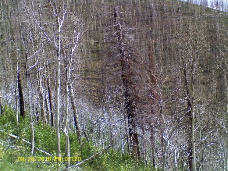
Because the trail is old and forgotton, there are few signs to identify it. Portions of the trail have been taken over by ATV routes, cross-country ski courses, and in a few short sections, newer dirt roads. Portions are faint and are a challenge to navigate. About six miles of the trail pass through a burned area caused by a 2002 forest fire. Because of infrequent trail maintenance in this section, the trail has about 400 deadfall downed trees to hop over. The entire trail can be found on topographical maps and on Unita High Wilderness maps.

I am attracted to this trail because vast sections of it are very runnable. The Uinta trails that run up the various river forks are boulder-ridden and cross numerous marshes making them difficult to run on. This North Slope trail is generally boulder-free and there are only a few short marshes to cross. Depending on trail conditions, your feet can stay dry except for a couple of fords across river forks. Most of the trail is in the forest so you don’t see wide-open vistas, with the exception of views from the burned-out area. This trail is excellent training for hill climbing because of the 7,000 feet of climbing on good switch-backs. This trail isn’t as remote as the Uinta Highline trail that I have run several times. On the North Slope Trail I would only see a couple people, but it crosses several river fork areas that contain dirt roads that are traveled every day by recreationalists.
For a couple weeks, I scouted out portions of the trail to learn the route. This was a challenge and involved getting off course many times. But I finally learned the route and was determined to run the entire length of the trail from Stillwater Fork to East Smiths Fork. To avoid shuttling a car, I decided to run it as an out-and-back for an adventure run of nearly 60 miles and do about 20 miles in the dark. I wanted to be the first person to run this trail end-to-end in one day and to establish a speed record for others to try to beat. The weather and trail conditions were perfect. There had been no significant rain on the trail for about a week so it had dried out nicely.
I started my crazy adventure at about 1 a.m. All was quiet at the trailhead. I took one hand-held bottle, and my Ultimate Direction Wasp lightweight backpack. I would use iodine pills to treat water obtained except for a few sources that looked safe near springs. I also brought, camera, GPS, phone/mp3, candy, four hot-pockets, instant breakfast, and beef jerky. I left my raingear home because there was no chance of rain. To stay warm, I brought a biker jacket with back pockets, gloves, and a ski hat. It was about 40 degrees at the start, but it would dip close to freezing as I saw frost in the lower portions of the trail. (For detailed trail description and directions, see below).
Away I went! It was nice to know the trail pretty well. I didn’t have to consult the GPS at all for the first few hours. Running on the ATV trail for the first couple miles was a blast. I pushed the pace pretty hard in the dark. Great fun, I was in my element. As I reached to single-track section through the burn-out area, I kept the pace going well as I leaped all the deadfall. I made all the correct turns only having a little problem navigating across a small marsh area where I had lost the trail last Saturday. But I quickly figured things out this time. To keep my mind occupied, I counted all the deadfall I had to jump over or go around. There were 160 in this section. I crossed Boundary Creek without a problem and spilled out onto the dirt road in the Boy Scout camp.

This Boy Scout camp is the site where unsupervised scouts started a terrible forest fire in June, 2002 that destroyed 14,000 acres in several of the canyons I was running through. The destruction left behind is still depressing to see. Aspens are returning, some about seven feet tall. The pines are much slower in coming back. In 2007 a lawsuit was settled by the Boy Scouts involving this fire.
I reached East Fork Bear River in only 47 minutes. I was very pleased because the first time I tried to run this section (last Saturday) it took me over two hours because of significant navigation problems. I ran very fast through the scout camp and was soon at the East Fork trailhead where I signed the register. I signed all the registers both going and coming as a safety precaution. If I croaked somewhere, the registers would help search and rescue know where my body might be.
The climb up towards Deadman Pass was nice but the climb went through burned forest and large deadfall along the way slowed me down. I counted 140 deadfall that I jumped over in this next section. As I was nearing the top, I saw a very bright light ahead. It l looked like a lit-up camp or backpackers with lights. But that didn’t make sense, it was about 3 a.m. I studied it closer and was amazed to find out that it was a huge crescent moon rising above the top of the ridge. It was an amazing sight. Over the top of Deadman Pass, now in the Mill Creek drainage. I was a little cautious because this was the location where I saw a mountain lion last Saturday. I pulled my GPS out to help me navigate to the trail that would take me to the next pass up and over into Cataract Creek. For about a mile I couldn’t find the actual trail, but I didn’t worry and just ran across grassy slopes in the right direction to the base of the steep slope up the pass. I then followed the GPS to the next waypoint and found the trail. My pace started to slow a bit as the trail became more rugged. I reached West Fork Blacks (mile 10.3) at 3:18 elapsed time.
My next climb up 1,400 feet to the ridge on top was nice and strong. But then disaster struck. As I ran across the top of the ridge, above the tree line, I lost the trail. No problem, that is expected in the dark. I pulled out my GPS but was shocked to see that the batteries were dead and I failed to bring backups. I continued to plow ahead in the direction that I thought was best. What should I do? It would be very hard to find the trail on the other side of the wide open ridge top. I just kept going and hoped for the best. I entered the forest but couldn’t find the trail. Was it on the left or on the right of me? I had no idea. Soon, I knew I was lost in the thick forest. Should I try to turn back? That would even now be tough to head in the right direction through the forest. I decided to just keep going. I used the moon ahead as my guide to try to keep on a straight course.

I knew that the correct trail connected with the headwaters of Brush Creek that headed northeast. Could I find it? I made sure that I continued in a downward direction, generally to the east. The stress of being lost was getting to me a little. Here I was in the middle of the night in a thick forest, miles away from anyone. Without a working GPS, I couldn’t tell for sure where I was. I knew that the Middle Fork of Blacks Fork was about two mile to the east where there was a trail. But I still had hope of finding my trail. In the dark, I came upon a creek bed with little pools of water. I followed it for awhile and it soon was flowing. Could this be Brush Creek? It was heading in the right direction. If it wasn’t, worst case is that I could just continue to follow it. All creeks and rivers eventually would cross the North Slope road about four miles to the north.
I discovered that I could follow the creek and make good time if I took a route above the creek in the forest. I knew if this was the right creek, the trail would eventually cross it and follow it on the east bank. So I ran along the east bank. Then I saw something, a clear cut section in the forest. Could it be? Yes! I was delighted to find the trail again. I was relived. I had wasted 15-20 minutes doing a slow pace, but my adventure was back on track.

I reached the Middle Fork Blacks Fork (mile 14.8) at 5:16. Dawn was approaching and soon I turned off my flashlight as I climbed to the top of the next ridge. My energy level was getting low and I started to bonk because I had not been eating enough. Thus, my pace slowed down but I continued ahead.

I reached East Fork Blacks Fork (mile 20.8) at 6:45.

The remaining 8.6 miles to East Fork Smiths Fork would be a mystery to me. I had never run this section before. I made my way to the river ford. It was almost knee deep and very cold. The air temperature felt below freezing. I pushed ahead quickly to warm up. At the next trail junction I met a bow hunter looking at a map. He asked my help to find the Bald Mountain trail. I showed him the way and he asked where I was going. I didn’t give him the whole story, just indicating that I was going to run to the East Fork and back. He was very impressed.

I loved the next section of the trail. This section between East Blacks and East Smiths is clearly the finest and most runnable leg of the trail. It is very well maintained. I could envision an ultra race on this section but unfortunately it entered in the wilderness boundary, so that won’t happen. Now recovered from my bonk, I ran at good speed on the rolling forest trail that was soft from pine needles. At 8:30 a.m. I noticed there was still frost on the ground in spots. I was never really chilled since I was always moving. I reached the West Fork Smiths Fork (mile 25.8) at 8:08. That was a slow marathon, but still a faster pace than running on the Unita Highline trail far to the south. I noticed trail signs that indicated that my trail was now named “North Slope Highline Trail.” I knew I was now over 25 miles. I thought my total run would only be about 50 miles, but I now knew it would be pushing 60 miles. I was so close to my goal that I decided to just continue on to the end of the trail.

I finally reached the end, the East Fork Smiths Fork (mile 29.4) at 8:56:46. I had just set the speed record for an end-to-end run of the Bear River – Smith Fork Trail.

The river was deep and flowing hard. I paused to celebrate and to eat my early lunch (It was only 9 a.m.). Thinking of the run back, could I break my own record? It was possible because going east to west is easier with about 600 feet less climbing and easier switch backs. I would give it a try! If I pooped out, I could always hitch a ride from someone in one of the forks back to the Mirror Lake Highway. But I never had to resort to that. I felt pretty good the entire run back, especially during the very fun section back to East Blacks. Up on the ridge top I could see the gigantic windmills near Fort Bridger far to the north. They looked like tall buildings. I tried to call my wife on my cell phone but the signal kept coming and going.

Coming down into the East Fork I first met a two ladies on horses. One of them was very rude to me, upset that I was running on the trail. She lectured me like I was a child, explaining that I could scare her horse, causing her to roll down the hill. All I did was say, OK and let them pass. My thoughts were, if she had such a spooky horse, what was she doing with it on a steep mountain trail? It bothered me that horse riders thought they owned this trail.
I returned to East Fork Blacks Fork (mile 38) at 10:53. The miles ahead seemed long and hard, but I knew I only had two very hard climbs ahead. I could do this. My main problem was water. With one water bottle and iodine, I had to wait 30 minutes after refilling my bottle. A few times I goofed and took a sip before the 30 minutes. Finally I got into a routine. Right before a creek crossing, I chugged down the rest of my bottle, then refilled and wouldn’t drink again for a half hour as the iodine killed any nasties. I also tried to be selective in which creek I used. I picked small creeks coming off ridges that I knew were not used by sheep. I was slow on the tough climb above the East Fork . This was the third time making this climb in the past three weeks. When I reached the area above Brush Creek where I had been lost during the night, I had great difficulty figuring out the right route even in the day. The cairns are just two small and spread out. Eventually I continued on the correct route.
I returned to West Fork Blacks Fork (mile 44) at 12:27. I dreaded the next huge climb ahead, but I just kept my head down and discovered that I could actually still run uphill. My pace was excellent and before no time, I was at the top. After cruising through the Mill Creek drainage, I crossed the field to the point where I knew the trail continued on up to Deadman Pass. I noticed a guy on a horse watching me closely from the distance. He was very curious to see me heading directly to this hidden trail. As I climbed ahead through the burned forest, I could see that he followed me. He probably had been searching for this trail to the pass. He almost caught up to me, but I crested the top at Deadman Pass and then ran with speed on ahead out of sight.

I returned to the East Fork Bear River in the Boy Scout camp (mile 55.2) at 16:52. Just one more moderate climb ahead! I no longer cared about my pace, just wanting to finish without any injury or major fatigue. In just seven days I would be running Wasatch 100, so I didn’t want to do anything at this point to hurt that race. I took inventory. My legs felt great, no soreness, my feet were a little sore, but I had not blisters. I was hungry and my energy level wasn’t too high, but that was expected. At the top of the ridge I got a good cell signal and called home to give my wife an expectation when I would return home.
When I reached the Wolverine ATV section, I knew the end was coming soon. I met a lady with her children walking on the boardwalk, enjoying the forest. I greeted them and ran on ahead with good speed. I was feeling fine. I moved off the trail for four ATVers going up the trail. One of them was a hunter and he stop to ask me about the deer I had seen. I had seen many, but none recently. I didn’t bother to explain how far I had traveled.

I finished my run, about 58.8 miles in 18:08 at about 7 p.m. My return trip at only been 12 minutes longer than my morning run out. It had been an amazing adventure. The weather had been perfect. I felt so thankful to have been able to experience this incredible day in the Uinta Mountains.
Could I do more? The North Slope Highline trail continues clear to Spirit Lake on the east side of the Uintas. Running all the way there would be a fun adventure.
Detailed Trail directions
To get to the west trailhead
To get to the western trailhead, take the Mirror Lake Highway to the turn-off for Christmas Meadows. This is a 2WD dirt road at about milepost 46, north of the bridge over Bear River. Drive south on Christmas Meadows road for about 1.5 miles and then turn left on a road heading to the Wolverine ATV trailhead. Follow this road for about a mile to the trailhead. There is no longer any signage for the Bear River – Smith Fork (BR-SF) trail at this trailhead. The Wolverine ATV trail has taken over this early portion of the trail. Using a GPS with waypoints on the trail will greatly help navigate.
Trail Directions
Wolverine Trailhead to East Fork Bear River (3.6 miles)
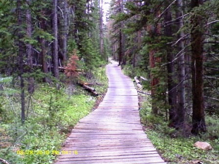
Run up the Wolverine ATV trail. It will initially climb steeply for 400 feet and then will roll through the forest. This is well-maintain trail that is fast and a blast to run on. There is a long section of boardwalk through the forest. At about mile 2, you will come to a well-marked single-track trail to the right where ATVs are not allowed. This is the BR-SF trail. It is also a cross-country skiing trail. Take this trail through the burned-out forest. I counted 160 deadfall trees along the next couple miles to hop over. Most of these are small and not bad. In about a half mile you reach a marked trail junction. The trail to the right goes to the Boundary Creek hert. Take the trail to the left. It doesn’t look like much of a trail, but you can clearly see the clear-cut straight route through the burned-out forest. In 0.3 mile you come to an open marshy area. It is very difficult to understand where the trail goes from here. Simply hug the boarder of the marsh on the left and you will eventually see the trail continuing to the north-east down a clear-cut section. It now descends on some switchbacks to Boundary Creek. Cross the creek, the trail makes a short turn to the left and then winds toward the dirt road the runs through the Boy Scout Camp. Note the cairns near the road if you are returning this way. Turn right on the wide dirt road, following it to the bridge over East Bear River.
East Fork Bear River to West Blacks Fork. (6.7 miles)
Continue on the dirt road through the scout camp, always staying on the main road up to the scout camp gated main entrance. Exit and turn right on the dirt road, running 0.3 mile to the East Fork Bear River trailhead. Run on this trail for a couple hundred yards to a signed junction. The river fork trail continues straight ahead, and an interpretive trail turns right. Look closely to the left, there is an unmarked trail. You can see the cross-cut downed logs. That is our forgotten trail, the BR-SF trail. The trail now is very easy to follow as it climbs the slopes, and makes some switchbacks. Large deadfall is a bother at times to get over or around. You will reach Deadman Pass which is marked with a small weather-worn sign. Continue ahead down the other side through burned forest. The trail may be harder to see, but horses also use this section so you should be able to follow it as it switches back through the trees. It finally spills out into a wide-open field. (Note where you exit, it is not marked for your return trip). You now can’t tell where the trail goes from here, but simply make your way to the dirt road ahead. You are in the Mill Creek area. Follow the road up and to the right. Stay on it until you come to another dirt road going down to the right. Take this road for a hundred yards. Navigation is now a problem. The actual trail crosses the road but is very faint and impossible to detect. Your goal is to continue straight east, staying above the fields below, and find a trail that switchbacks up and over a ridge to the east. So just traverse the gental slope, heading east, staying above the bottoms. When you finally reach the far east end, it should be pretty easy to find the trail that switches back and forth up the sleep slope to the ridge. Go up and over the ridge. The trail is very easy to follow as it descends. About halfway down it crossed Cataract Creek and continues down until it reaches West Fork Blacks Fork River.
West Fork Blacks Fork to Middle Fork Blacks Fork. (4.5 miles)
Ford the river. If the river is low, you can keep your feet dry. After the crossing, it is a little confusing. But simply keep heading east for a hundred yards to a road, and turn left to the major trailhead. At this trailhead you will actually see a sign identifying the Bear River – Smith Fork trail. The trail heads directly up east from this sign. The trail is very easy to follow and gets plenty of horse traffic. It switchbacks all the way to the top of the ridge and then becomes fainter as it goes through sparse forest and spills out onto the wide-open grassy ridge. Mount Tokewanna is off in the distance to the right. The next half mile is very challenging. There are cairns, but they are spread out and hard to detect. The route heads east but also little north and will descend toward the headwaters of Brush Creek. On the other side of the grassy area, the trail is again distinct as it re-enters forest. You can also see the clear-cut through the forest. Brush Creek eventually appears to the right, the trail crosses it and then continue follows it to the north-east. You will come to an area that has been logged. It is confusing to know where to go from here. The trail turns to the east. Look for boot or horse prints. That might help you find it, or just make a wide circle. From here the trail is very easy to follow. It will cross a couple short marshes and then continue down through the forest to Middle Fork Blacks Fork. Right before the river, there is a trail junction, perhaps marked with flags. The BR-SF trail contines ahead and down to the left to the river.
Middle Fork Blacks Fork to East Fork Blacks Fork (6 miles)
Cross the river (probably can keep feet dry) and pick up the trail on the other side. From here, the trail is very easy to follow all the way to East Fork Blacks Fork. It switchbacks up to a couple low ridges. For about a mile, it is fairly level and fast, great fun. It then descends using switchbacks and crosses a major dirt road in t he East Fork. (Note the trail sign that again mentions the BR-SF trail). You have decision point. Do you want to ford the river ahead or make a one-mile detour to use the bridge a half mile up the road to the right? To go with the ford method, cross the road and follow the dirt road for only about 100 yards. Keep your eye out for an unmarked trail to the right. Do not follow the road after it turns to the north. Follow the trail to a major trailhead near the river.
East Fork Blacks Fork to West Fork Smiths Fork (5 miles)
Ford the East Fork. You won’t be able to keep your feet dry unless you took the bridge detour. In about a quarter mile your reach a junction with the trail that goes to the bridge. Stay left. The trail from here is very well-maintained and gets plenty of foot and horse traffic. It is very runnable and nice for the rest of the way as it uses long sweeping switchbacks. After reaching the top of the ridge, you reach a major junction. The Bald Mountain trail goes to the right. The BR-SF trail goes to the left. At this point the trail has been renamed and renumbered to North Slope Highline Trail (105). Run fast on this section, it is soft and rolling, using gentle switch-backs up and down the ridges. There is one short section across a field that is confusing because the trail fades and the cairns may be hard to see or gone. Simple head straight across and pick the trail back up on the other side. At the West Fork there is a trail junction with a sign. It identifies our trail as “N-S Highline.”
West Fork Smith Fork to East Fork Smiths Fork (3.6 miles)
Cross the creek and continue on. The trail is very easy to follow. It will make switchbacks down to the East Fork. The East Fork is a wide, deep, fast moving river. This is the end of our trail. Trail 105 continues across the river and junctions with the Smith Fork Trail that heads up to the Red Castle lakes.
Ridiculous sums it up pretty well. Awesome also does it justice. Congrats.
Thanks for keeping me updated with your runs, even though we’ve never met. What you do motivates me. I’m not like you – just don’t seem to be able to do the long stuff – but I keep putting one foot in front of the other whenever I can. Keep going and good luck.
G
Sounds like a nice run. Good luck at Wasatch.
Very awsome like always Dave you impress everyone especially me!
Very awsome like always Dave, you impress everyone especially me!
Davy
Having spent many a Scouting venture in that neck of the Uintas I have to say you have done something few could do. You have a record that likely will not be broken because of your thoroughness in preparation and contingency planning. I am grateful that you were blessed with protection, guidance when intuition had to be trusted, and good physical conditioning.
Anne Romney, your cousin, spent the last month up in the Mirror Lake area collecting edible mushrooms. She has pictures of those that were edible and those that are questionable. The edible ones we have all greatly enjoyed. They are very similar to the characteristics of those in France.
Good luck on the Wasatch 100! You are truly amazing, and an inspiration to all of us who would like to run in your footsteps but lack the training, discipline and courage.
Love you, my dear nephew! Uncle Gordy
Very cool, Davy. I’m still dreaming of doing the highline trail as a two-day run. Meanwhile, I continue to live vicariously through you. :- )
P.S. Note the name change! :- )
Fantastic! You get to enjoy such beautiful country.
You were just over the mountain from where we spent this past weekend. We were on the Weber River, as far as you can go by motorized vehicle. We were there in 2002 and saw the smoke from the scout fire. Thanks for sharing this adventure. You have a crazy schedule coming up. Stay well.
Nice! I’m stoked to stumble across this as I plan another somewhat random Uinta trailrun link-up. Great info. I’m always stoked to stumble across your adventures as I muse about other potential adventures. Cheers on thinking outside the box!