

May 20, 2006
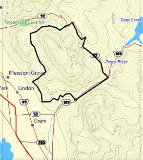
Once again, I decided to get creative with a Saturday training run. The snow has been melting like crazy in the mountains this past week and I thought it would be safe to climb up toward 9,000 feet. I decided to try something new. Instead of climbing my favorite mountain, 11,749-foot Mount Timpanogos (above Provo/Orem, Utah), I was going to circumnavigate the mountain — 38 miles in one morning! Trails exist all the way around the mountain except for a 9.5-mile stretch of paved road from Aspen Grove down through Provo Canyon. I could run/hike all the way around this immense mountain. I wanted to end out with the long paved downhill, so I planned to start my adventure from the lowest point (5000 feet) at the Canyon Glen picnic area in Provo Canyon and would climb up the Great Western Trail that carves around the front (west) side of Timpanogos. With an early start in the morning, I would enjoy the view of the city lights below. I would reach a height of 8,600 feet during my run.
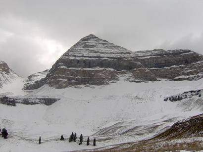
Timpanogos summit, picture taken last Fall
I had no idea how long this would take. I had never run the trails on the front side of the mountain, so I started very early. At about 2:15 a.m. I commenced my adventure in the dark, early morning. I love running at night. I was greeted at the trailhead by a group of young hiker/partiers returning to their cars that looked at me with wondering looks. Where is this guy going so early?
I took with me my trusty GPS which would be a critical navigation tool. I immediately wished that I had plugged in many more waypoints for the Great Western Trail, because I very quickly lost the trail, evidently taking a trail into a side canyon. For the next half hour I wandered back and forth, trying to find an established trail that I knew was there somewhere. I passed by a group of tents, trying not to bother them.
My green flashlight attracted attention from nocturnal Friday-night adventurers. As I wandered in the bushes above a makeshift campground, a gruff voice called out to me. I called back and decided to visit. It was a guy sitting alone by a campfire at 3 a.m. I asked him if he knew where the Great Western Trail was. He didn’t have a clue as to what I was talking about. He acted like he was stoned. I moved on. I heard a bunch of loud young adults further up a canyon and periodically saw their lights. They too called out to me. I felt embarrassed wandering around, searching for the trail. I followed a sparse trail toward them and eventually a guy approached asking me if I was lost. He said he had been following my green light for some time, ever since I entered the basin below. He and his group of friends were having fun, camping out and hiking in the dark. He took me to their camp that was in the general direction of my next GPS waypoint. The others greeted me and asked who I was. “I’m the green light guy,” I explained, not sharing any more details. I said I was trying to find the main trail. I didn’t want to explain to them that I was running around the whole mountain. There was no way they would believe or comprehend that fact. The guy thought that the only established trail on a ridge above. That was where my next waypoint was, so I bushwhacked up to ridge, following my GPS, and was pleased to find the trail.
When I reached a junction with what once was the Alta Canal, I again lost the trail. I tried various routes to find it, but I just didn’t have enough waypoints in my GPS to help. I finally gave up and decided to follow the Bonneville Shoreline Trail, a very established flat trail that winds through the foothills. (Anciently, a deep lake, Bonneville Lake, covered the valley below. A very obvious ancient shoreline can be seen in the foothills. A very nice trail has been established on many sections of this shoreline.) I knew this would add many more miles to my adventure, but I was wasting too much time trail hunting and bushwhacking. It was good to finally do some steady running and progress some miles. A couple times I tried some side trails that seemed to climb up the mountain in the right direction, but the trails fizzled out, so I returned to the shoreline trail and was just content to twist around the ridges and enjoy the run.
The lights of the city below were an impressive sight. If I turned around and looked up, I could see the snow-capped mountain ridges above, reflecting the lights from the city below. At times I was very close to homes that are creeping up the mountain. I started to feel dehydrated. In my concentrated quest to find trails, I had failed to fuel myself properly, so I quickly drank my lone water bottle and felt much better in a few minutes. I hoped that I would soon find some clean runoff to refill. I had planned to be much higher on the mountain with easy access to melting snow. I finally reached a trailhead parking lot for what I think was the Dry Creek trail. The shoreline trail seemed to end so I decided it was time to climb. The trail/road was easy to follow and it climbed up the mountain. As I went higher, I started to see water seeping in places. Good, I would need it soon. Then I came across a spring, a pipe coming out of a bank, spilling water into a little pool. What luck. I drank to my heart’s content and refilled my water bottle.
I next stumbled on a wonderful single-track trail, fairly level, that headed north, in the right direction. I knew it wasn’t the Great Western Trail, because it was still far below my waypoints, but it would do nicely. The light of dawn arrived and I was soon able to turn off my flashlight. I missed a turnoff and the trail brought me to an overlook of Battle Creek Canyon. My knee started to bother me pretty bad. The kneecap was sore and started to pop a little. I backed off and was careful, letting it calm down. Instead of trying to race around the mountain, I would just enjoy the wonderful mountain trail.
I backtracked to the main trail and then descended into valleys and basins. I could hear the roar of Battle Creek and eventually crossed over it at a huge snowfield. There were some flags marking the trail across on the other side of the creek, so I followed them. I soon discovered why the flags were there. They led the way to a pretty big encampment of boy scouts. It was about 6:30 a.m. and the scouts were still asleep in their tents. I did see a leader sitting by a campfire. I stopped to ask the man if I had lost the trail. He told me that I had, if I wanted to “climb the peak.” I didn’t want to try to explain what my crazy adventure really was, so I just backtracked to the main trail. (In hindsight, I should have told him what I was doing. It would have been an amazing tale for the boy scouts at breakfast.) As I climbed up the Battle Creek Trail, I continued to pass numerous tents. No one was stirring yet, so I tried to be quiet as I passed.
A couple times, beautiful deer would bound ahead of me on the trail. They were a wonderful sight to see in the early dawn light. The terrain was beautiful forest, maples and aspen groves, opening up into grassy basins. The trail continued to climb until it finally reached one of my GPS waypoints. I was again on the Great Western Trail. I quickly linked up with a rugged 4WD dirt road, the Timpooneke Road. I made some good time on the road, weaving around ridges. I had my tunes playing on my MP3, so I sang out aloud as I ran. Far below in a basin above Grove Creek, I could see another group of campers beginning to stir. I think they noticed me on the road high above them. They were probably saying, “Where is that dude going running and singing?”
I finally came into a basin with a sign marking “Indian Corral.” At that point, the basin was full of snow and I couldn’t tell where the road was, but there was a well-defined trail heading generally in the right direction, so I took it. That worked well until I came to a giant snowfield. I couldn’t find where the trail continued. My GPS claimed that the road was above me, so I climbed the snowfield for a while. I couldn’t see any road coming up and it looked like I would have a difficult bushwhack above. So I returned, bounding down the snowfield, and spent the next half hour trying to make progress in the snow through the trees. It was slow going, so I finally decided to trust my GPS and it indeed led me up to the Timpooneke Road. My elevation was now above 8500 feet and there were snow mounds on the road at times deeper than four feet. I was feeling very isolated. There was no sign that humans had yet ventured this high, this year. I was now miles away from anyone.
At 8:00 a.m., I had a weak cell signal, but couldn’t succeed in making a phone call home. I hoped my wife wouldn’t worry. I knew this would take much longer than expected. I continued to follow the road. It was slow progress for the next few miles because the road was almost totally covered in snow. At one point I had to traverse across a huge, steep snowfield that had experienced several avalanches during the winter.
I started to have thoughts about bailing out when I would reach the Timpooneke Trailhead. I could take the easy way out and just run down American Fork Canyon and call my wife to pick me up. This was taking too long and it seemed like I was still not half way around the mountain. I could see plenty of deer tracks in the snow along the road. My tracks were the only human tracks. It looked like I was the first one up there this season. As the road gradually descended, bare spots without snow stayed longer. I finally was able to keep a nice run going, and descended into the Timpooneke campground. I was surprised to see a car pull into a camping area. After being alone in a very isolated area, it felt good to be a little closer to civilization again.
I was very thirsty, so I filled up from an icy little runoff stream. I next reached the Timpooneke trailhead, a place I am very familiar with, where I start my runs up the mountain during the summer. I checked the map there and determined that I would follow the Great Western Trail for a while and make my way up other trails to the Alpine Loop Summit. The day was clear and the sun was getting warm. I failed to bring any sunscreen or sunglasses with me, because I thought I would be finished much earlier. At about 10:00 a.m., I reached the Alpine Loop Summit. It would be all downhill from here! There was no turning back now, I would complete the loop around Timp. I started a very pleasant run down the soft trail toward Aspen Grove recreation area. I had cell coverage, so I called my wife, told her I was fine but was taking my time.
A few minutes later, I ran into a guy bent over, working on the trail. A lone trail worker? Hold it, his hat looked familiar, a Bear 100 hat! He also wore a Zane Grey 50 shirt. He looked up and said casually, like he was expecting me, “Hi Dave.” I was shocked! It was Phil Lowry, one of my training buddies! A few weeks ago we crossed paths unexpectedly in the Grand Canyon in the middle of the night. It happened again this morning! He had just completed his first Timp summit of the year using mountaineering gear. Now he was doing a morning run up this forested trail. I just couldn’t believe it. With all the thousands of miles of trails in Utah and Arizona, we keep bumping into each other! He was heading up, I was heading down, so we wished each other well.
I continued to descend and soon reached Aspen Grove. There were plenty of youth groups starting out on hiking adventures. I’m sure I was a sight to see. I was filthy, with scratched, bloody legs, and still holding a flashlight. I hit the paved road and started the long pounding run down the Alpine Loop road, passing Sundance Ski Resort, and finally reaching the Provo Canyon Highway. It was getting hot and noon was approaching.
As I almost reached Vivian Park (the start/finish location for the Squaw Peak 50 scheduled two weeks from now), Phil drives up, honks his horn, and yells out his window asking if I wanted a ride. I only had about three miles left and wanted to finish the loop so I declined. He made fun of my “ultra shuffle” slow pace on the pavement, so I kicked it into gear for a few long, fast strides. He laughed, wished me well, and drove down the highway.
I finally reached the Provo River Parkway, a paved trail that runs along the river. It was filled with bikers, skaters, runners, and walkers. What a beautiful day to be out! My legs were really complaining now because of the hard pavement. With about a mile to go, I slowed to a fast walk and took it easy in the home stretch.
At about 12:45 p.m., I reached my car again. I had completed a run around Timp! With all my detours, I later figured out that I had run about 38 miles in 10.5 hours and climbed about 9,000 feet in elevation. It had been a pretty grueling training run. The pavement left me with sore feet, but I came out of it without any injuries. I witnessed this morning some of the greatest beauty of the Wasatch Mountain range. I traveled mostly between 7,000 and 8,500 feet. I experienced beautiful forests, basins, creeks, raging rivers, cliffs, snow-covered peaks, early spring wildflowers, aspens with new leaves, and snow-covered trails. I saw it all this morning!
Davy, I’ve been thinking of doing this run, but just haven’t gotten out to do it. I didn’t know that you had done this until I came across this post. The closest I’ve come to doing this is running up Grove Creek Canyon, running to Timpanooke TH and then over to Sundance where I had someone pick me up.