

 When my backpacking buddies started to discuss a destination for our annual trip, I suggested “The Maze District” of Canyonlands National Park. I knew very little about it, but did know it was very remote and we love hiking in remote areas. The Maze is one of the most remote areas in the United States and among visitors of Canyonlands, only about one percent of the visitors go there and I would bet less than that.
Last week, one of my buddies who is very experienced with off-roading went to investigate and came back with a great report. However accessing The Maze would require hours of very rugged 4wd driving or getting dropped off by boat on the Colorado River. I found a report from some ultrarunners who had run a multi-day 100+ miles there in 2013 so I believed I could access the area by running, without hours of rugged driving on longer routes.
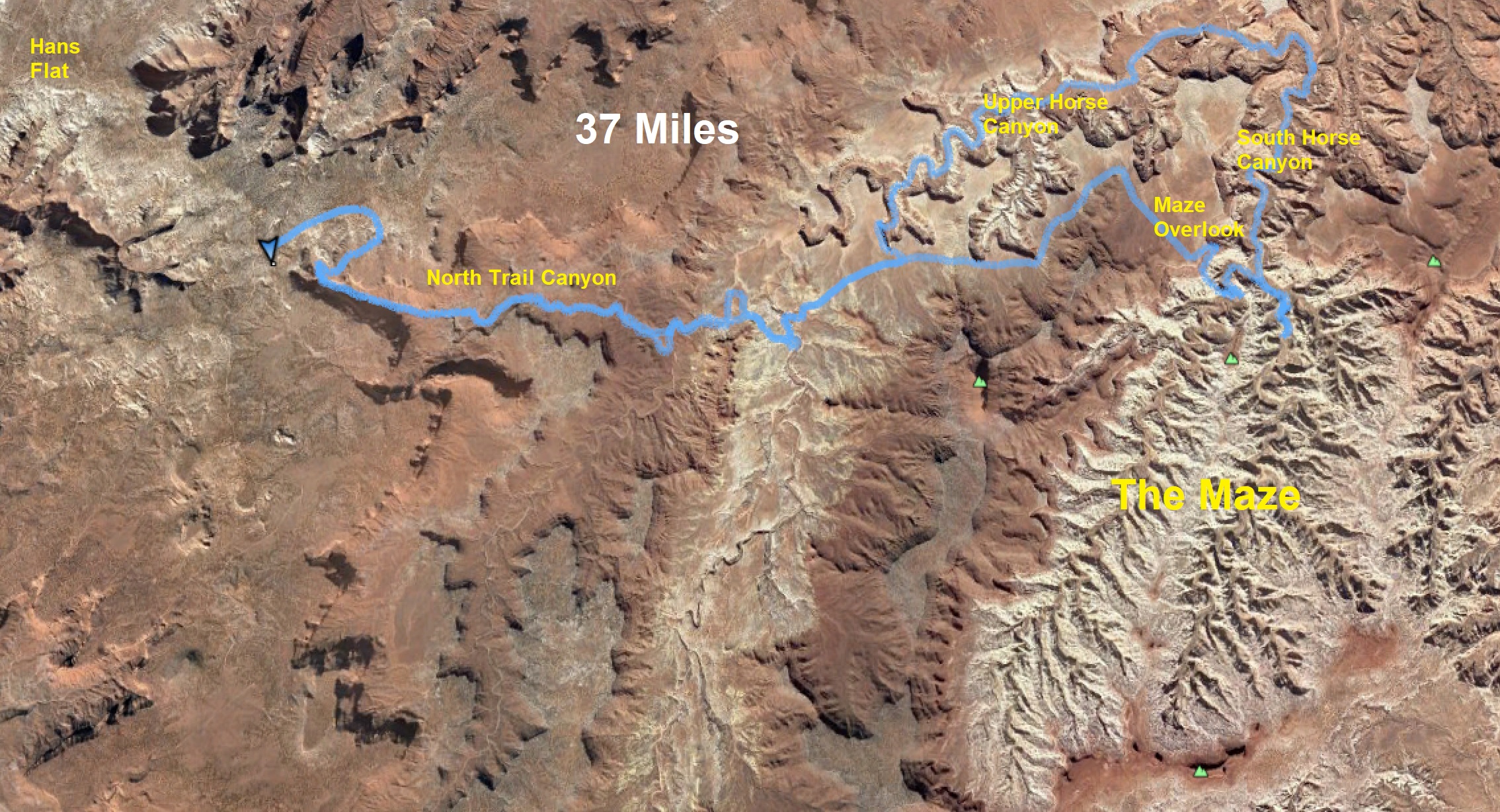
 As I researched, I found a route where I could access the heart of the Maze on foot with only 13 miles one-way instead of hours of 4wd driving. I could get there much quicker and easier (for me). For this run, water sources can really be a problem. Don’t try this in the hot summer. I would only do this in early spring or late fall. There are springs here and there but not for my route. Because of recent heavy state-wide rain, I knew finding water wouldn’t be an issue.
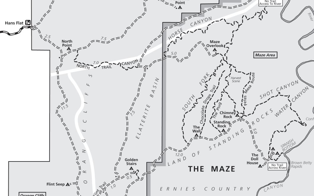
My first goal was to drive to Hans Flat ranger station, about a two-hour drive from Green River, Utah and about 40 miles of dirt-road driving. Normally it can be accessed by a 2wd vehicle. However, because of the drenching rain the day before the road was very slick and muddy. It took me three hours to get there and it was very stressful. At times I had to drive only 5 mph to avoid sliding off the road. A couple miles before Hans Flat were several mud bogs that were difficult to get my Hyundai Santa Fe through, but I made it. I was nervous about going further, but I continued on for two miles to my starting point, the North Point camping area which is about 300 yards off of the main Flint Road. If careful and good road conditions a 2wd car can possibly make it to my starting point getting over a few short slickrock sections near the end, but higher clearance really should be used.
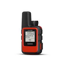 With this solo run in such a remote area, I took precautions. I bought the new Garmin Mini inReach unit which is as small as a SPOT device but much better because you can both send and receive texts via satellite. It worked perfectly for me. My family and buddies could watch my progress online. I also had a couple mapping apps on my phone that work with GPS even when in plane mode to not drain the battery. But just in case, I also brought a small charger block. As backup for all this, I brought a paper map and could use the compass on my Garmin watch. I felt confident, but I’m always nervous about running solo in a remote area I have never been to before. I carried only two handheld bottles, some food in my pockets and a very tiny pack to carry my stuff and more food. I like to travel very light so I can run faster and further.
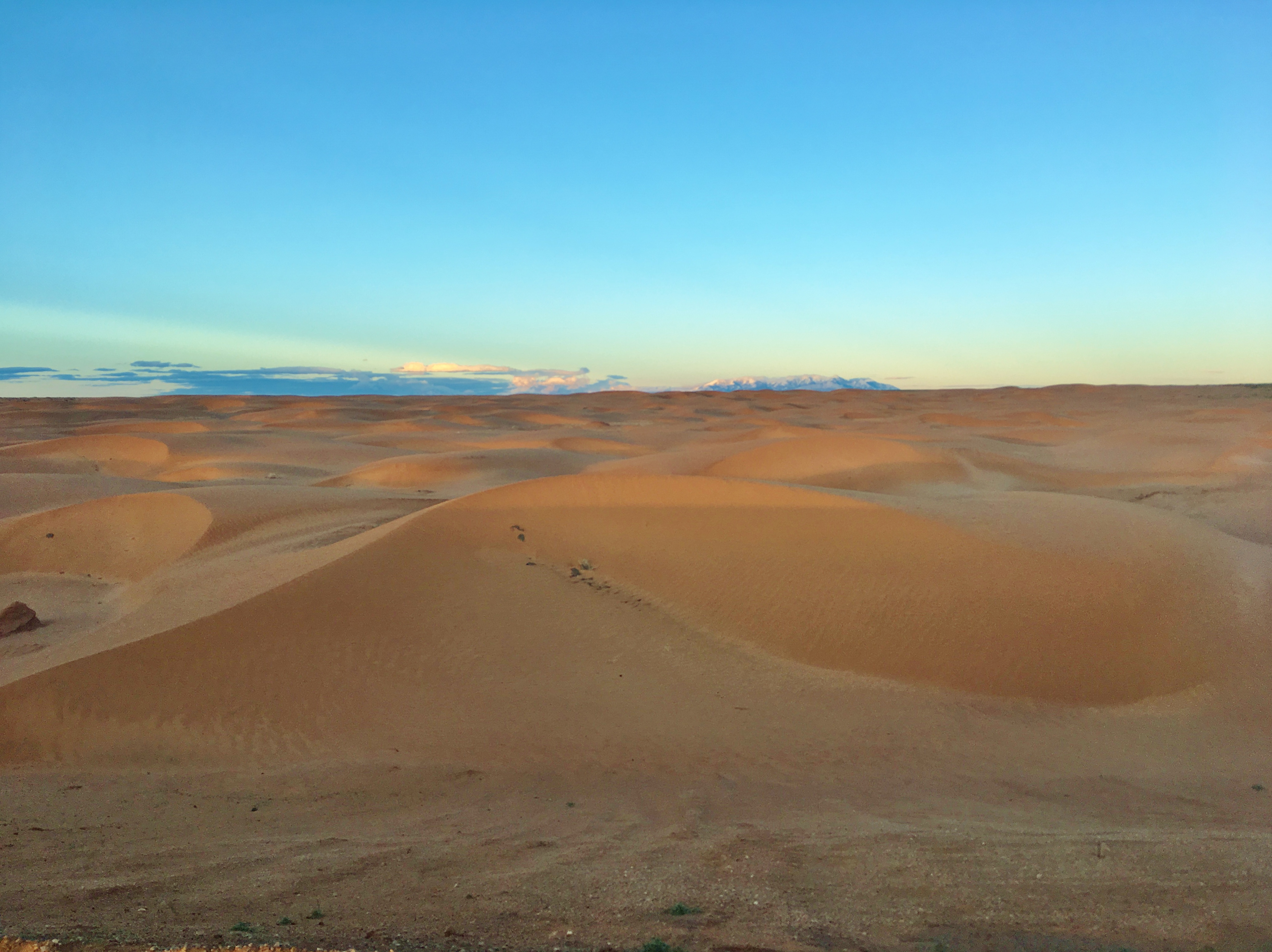
 It was perfect weather, cool, not cold, and never hot, with no rain. I sent an inRreach text to my wife and my backpacking buddies letting them know I was starting. I began at about 8:30 a.m., ran down the North Point Road about a mile and found the well-marked trailhead for the North Point Canyon trail. I was delighted to see how well-marked the trail was. First, I had a delightful run on the rim through pinion and juniper forest. The deep canyon came in view along with an impressive monolith. I started my quick 1,200-foot descent into the canyon. As I was having great fun, my first text came in from my buddy Carl, telling me to be safe. I sent a reply. It was comforting to know communication was working.
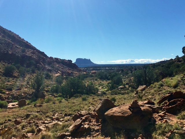
Soon Elaterite Butte came into view which I would continually head toward. The running was at times in the creek bottom, and other times jump up onto low sandy rises to avoid pour offs or turns in the creek. It was easy to follow with plenty of cairns. As I spilled out into the more wide-open canyon, I became more concerned about obtaining water. Because of the flooding the day before, there were water pools everywhere, but they were very muddy. But soon I came upon little water pockets with rain water that the muddy creek didn’t reach and I drank plenty, saving the water in my bottles for later.
 After seven miles, and only about 1:30, I reached the rugged dirt road that heads to the Maze Overlook. A very high clearance jeep went by. If they would have came from where I started, it would have taken them several hours driving rugged roads for more than 20 miles.
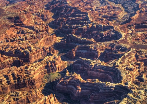
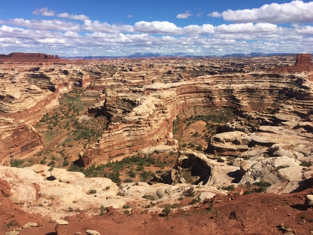
I could run directly five more miles to the Maze Overlook and descend into The Maze using the Maze Overlook Trail, but that trail is very exposed and requires some climbing maneuvers to get down it. That violated my solo running standards for safety. I don’t want to be one of those runners that they say, “At least he died doing what he loved.” I know if I would have continued there, I would have bailed out on that scary descent. So instead, I would take a longer route and descend on a safe trail into Upper Horse Canyon, to South Horse Canyon, to the maze. It was six extra miles, but was spectacular canyon running instead of more desert dirt road running.

I found the trailhead to lead into Upper Horse Canyon, which a Waypoint on my GPS map helped me find. I quickly came into a massive slickrock area above the canyon with many water pockets filled with yesterday’s rain water. I drank deeply and filled my water bottles, continued running along the rim of the very deep canyon with cliffs. I wondered how I would get down there and just followed the cairns. Soon the well-marked trail down came into view and my stress went lowered as I discovered the steep trail was good and pretty safe with no need to use hands. I descended about 400 feet to the canyon bottom.
 This canyon was more wide-open than the last canyon, with sandy wash running. I would run in it for seven miles. Normally it would be very dry with no water until the confluence with the South Horse Canyon.
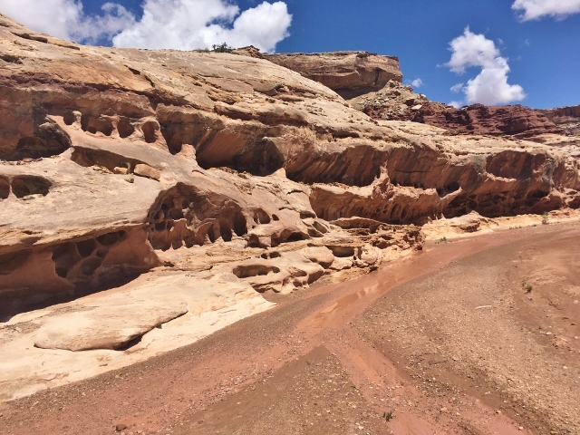
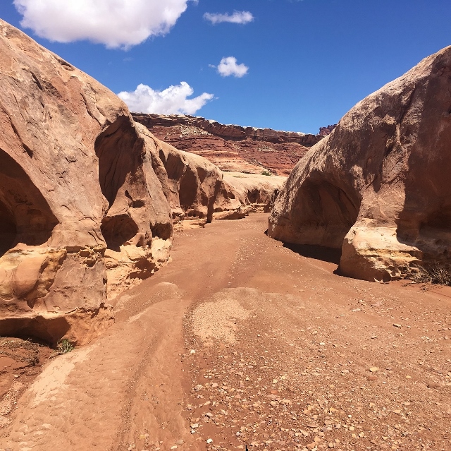
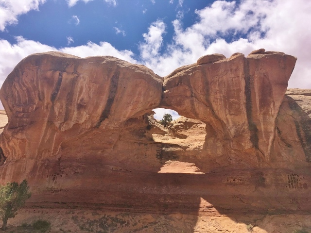
 I ran by many interesting rock formations and at times the canyon would narrow. I ran by one of the several arches I would see along my run. I also ran through a section with petrified wood scattered everywhere.
 I was getting concerned about my time, wanting to finish before dark, so I tried to push the pace and reached the confluence with South Horse Canyon (mile 17) at about the five hour mark at 1:30 p.m. Yes, I had been taking my sweet time, taking many pictures and doing site seeing. The confluence was obvious with many green trees and deep pools, probably from a spring. I filled up again and then headed up South Canyon toward the heart of The Maze.
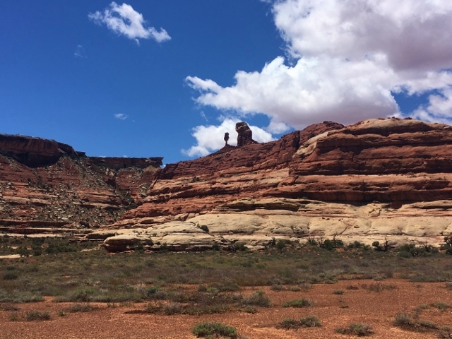
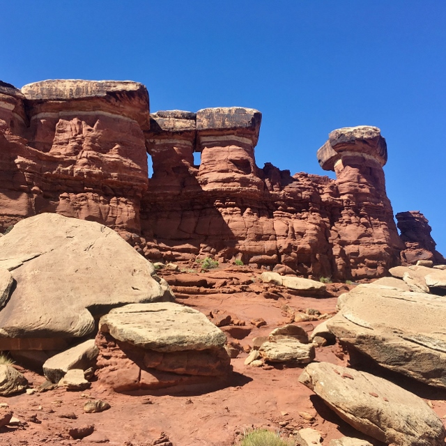
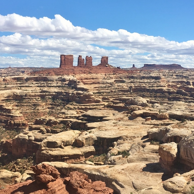
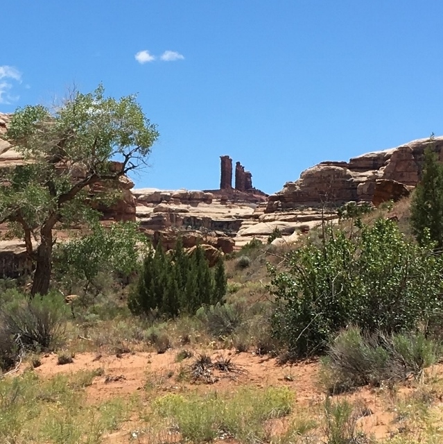 Soon the very impressive “Chocolate Drops” came into view. I was continually heading toward them and passed by more arches. Once in the heart of the maze with all the intersections of side canyons, I became very turned around and needed to consult my GPS map app. It was indeed in a maze. I realized I was near the Harvest Scene, impressive petroglyphs. I assumed they would be easy to find with a worn trail to them, but I just couldn’t find them quickly, so missed them.
 I was worried about my time, and nervous about finding the climb out. If the climb was too difficult, I would have to retrace my route and would finish after dark. But I used my map app, navigating a maze of canyons and eventually found the right trail heading up.
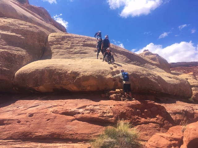 I heard noise ahead and realized there were some hikers ahead of me. They turned out to be a group coming down. They were at the first climb section for me. A guide was with them and he immediately could tell I was an ultrarunner. I let him know that I came from Hans Flat and was on mile 23, heading back. He was pretty amazed. As I watched his group coming down, I asked if this was the most difficult section because it didn’t look bad. Others with him said, no, there were plenty other tougher sections. My heart sank and worry went up. The guide gave me confidence and told me to just make sure I found the good handhold grips and I should get up fine. He added that they would be coming back up to the overlook where they were camped. If I had trouble, they could help me get out.
 They left, and I was on my own. The first climb in the picture was no problem, but then I came upon other climbing obstacles, some with very exposed cliffs. My stress went way up. Having someone along to give me a boost up would have greatly helped, but I was on my own. Each time I had to examine closely and figure out the best way to get my old bones and problem knee up the rock faces. They were never very long, but my rock climbing skills are nil, and I just had to figure things out.
 The higher I went, the views became more amazing, with the chocolate drops and maze of canyons below. Finally, after much stress, some shaking, to my great relief, I reached the top of the Maze Overlook. I was glad I came up rather than heading down. That would have been harder to navigate and more difficult to get by certain obstacles. It had taken me about 45 minutes to get up the 500-foot climb alone.
 It was now nearly 4 p.m. and I had 13 miles left including a massive climb at the end. Could I finish before dark? I really didn’t want to do the final climb in the dark. I had not been eating enough so was fatigued as I tried to kick it into gear. I stopped at the slick rock pools and filled up for the home stretch. I did a much better job at following the actual trail up North Point Trail Canyon, avoiding running as much in the creek bottom. I had to be very alert to make sure I saw the cairns as the canyon was shadowed as the sun was going down. I attacked the steep climb out of the canyon and was relieved when I reached the rim just as the sun went down. As I finished my run, I reflected how wonderful it had been. When I reached my car, some people with a jeep were setting up their camp for the night. The drive back out on the dirt road was much easier and faster. It had dried out quite a bit.
So ends my first run in The Maze. It was my first major adventure run in nearly two years because of my injury. I was so pleased to do it. To me these runs are what I seek to do, much more fun than the races.
Awesome write-up! this sounds like it was a fantastic adventure. I have backpacked through there and just this morning was pondering if someone had made a run of it. :)