

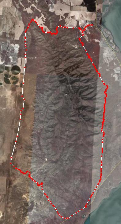
Running all the way around Lake Mountain is a nice long run a little over 50K. The run gives you wonderful views of Utah Lake to the east, and the expansive Cedar Valley to the west. This route is almost all dirt road with a couple of miles of pavement. Because of the recreational shooters who like to shoot anything that moves, care must be taken to run the east section before sunrise.
Directions
To start/finish at Saratoga Shores Elementary School, Saratoga Springs:
Travel west of Lehi to a major crossroads with a Smith shopping center, take State Hwy 68 (Redwood Road) South. After about 3.5 miles, turn right into Saratoga Hills development. The school under construction is up the hill, on the left.
Start/Finish – Mile 0 – Saratoga Shores Elementary School
From the school, head east up the main road – Grandview Blvd (Formally called Clay Pit Road). This will be a nice uphill warm up. In 0.5 miles you will come to a gate on the left to the gravel pit/land fill. Hop over the gate and continue up the road, steering right past huge mounds of gravel, up toward Lake Mountain. Continue on the dirt road toward the power lines. Turn left on the ATV trail right before you reach the power lines. Your objective for the next ten miles is to stick on a trail/road that follows close to the power lines. Sometimes there are dead-end access roads. Choose the roads that look like they continue to the south. Usually the road you want are on the east side of the power lines.
Mile 2.6 – Israel Canyon Road
After an enjoyable warmup run on rolling foothills, you will reach a major dirt road which heads up Israel Canyon to the top of Lake Mountain. The powerline ATV road does not directly cross this road. Turn right up the Israel Canyon Road for about 100 yards until you find an ATV road that countinues south. It will eventually join the powerlines again. The trail will continue along rolling foothills, giving you spectacular views of Utah Lake and the lights of Provo/Orem. Pelican Point rock quarry will be off in the distance by the lake. The course will bypass Pelican Point, and will instead go up and over Enoch Divide.
Mile 7.2 – Enoch Divide
This is the high elevation point of the course. 5,800 feet. As you go over the divide, Mount Nebo will come into view to the south. The next five miles will be a very pleasant downhill, still following the powerlines. You can really crank it up as you lose 1,200 feet of elevation over the five miles. Stay on the powerline dirt road.
Mile 12.5 – Hwy 68 (Redwood Road)
The powerlines cross the highway. There isn’t a good trail at this point on the east side of the highway. Time for 1.2 miles of road stomping. There isn’t much of a shoulder, so be careful. The drivers are maniacs along this section and they will give you strange looks, wondering why you are running on the road in the middle of nowhere. Keep on the highway until you reach Soldiar Pass Road, a main dirt road on the right that has a stop sign.
Mile 13.7 – Soldier Pass Road
Run up Soldier Pass Road to the west, up and over the pass. The pass is at 5,300 feet, at the 16-mile mark. On the other side, the road takes a swooping switch back that can be cut off with a nice straight ATV route. Keep following the road to the west. It will curve to the north and start heading toward the mountain. If you would keep following it, you would go to the top of Lake Mountain. Instead, take a road to the left that again heads you north and then goes down into a dry stream bed heading west. This is a great two-mile run down a small winding canyon. Your goal is a dirt road down in Cedar Valley, just east of some powerlines that heads to the north.
Mile 19.4 – Lake Mountain Rd.
Lake Mountain Road is a well-maintained dirt road that stays east of the powerlines. Turn right (north) when you reach the road. To the west, across the valley, you can see off in the distance the town of Fairfield, where Johnston’s Army camped during the “Utah War.” To the northwest you can see the town of Cedar Fort, tucked up against the mountain range. Our route will take us straight north toward Eagle Mountain. Cruise straight north along the road. You will be heading straight for eight miles.
Mile 25.7 – Eagle Mountain Blvd
Eagle Mountain Town center will come into view to the west and you will pass by it, about a half mile to the east. The dirt road (Lake Mountain Rd) will reach a paved road, Eagle Mountain Blvd. Cross over the road, continuing to head north for two more miles. You will cruise by some ranches. You head toward a valley that will cut through the foothills.
Mile 27.3 – Road to the east
Turn right at the powerlines (east) on a road heading up a small canyon to the east. The powerlines and a recently constructed buried oil line also head this direction. the road will eventually open up into a hidden valley with plowed fields. Continue on the road until a junction. Take a right turn, saying on the right side of the field, heading south and east up toward Lake Mountain. Out goal is to go up and over a ridge, As you reach end of fields go to the edge of the ridge looking down into the canyon to the west. Unfortunately there isn’t a good trail down. Try heading north on the ridge for a little way and you should see an ATV route down. If you can’t find it, just bushwhack. Go down into Reformation Canyon. There is a dirt road at the bottom of the canyon. Note: Careful here, there could be shooters down in the canyon. If so, get their attention before descending.
Mile 30.1 – Reformation Canyon
Run down the canyon to the north. As you come out of the canyon turn right on a dirt road to the east that will hug the foothills and pass south of the large Church welfare farm fields. Utah Lake will be in sight. Continue toward the lake and you will eventually hit the Clay Pit road that will take you back to the start/finish area at the school
Mile 33.0 – Finish
Only six runners have completed this run: Davy Crockett (6), Brent Rutledge (2), Mark Ellison (2), Jim Skaggs, Dave Wade, and Craig Lloyd
1 – May, 2004
2 – Nov 13, 2004 – (with Jim Skaggs and Dave Wade)
3 – Nov 20, 2004 – reverse direction
4 – May 14, 2005 – 6:23
5 – Nov 11, 2006 – 6:45 (with Brent Rutledge and Mark Ellison)
6 – July 2, 2009 – 5:29 PR (with Craig Lloyd) 31 mile loop