

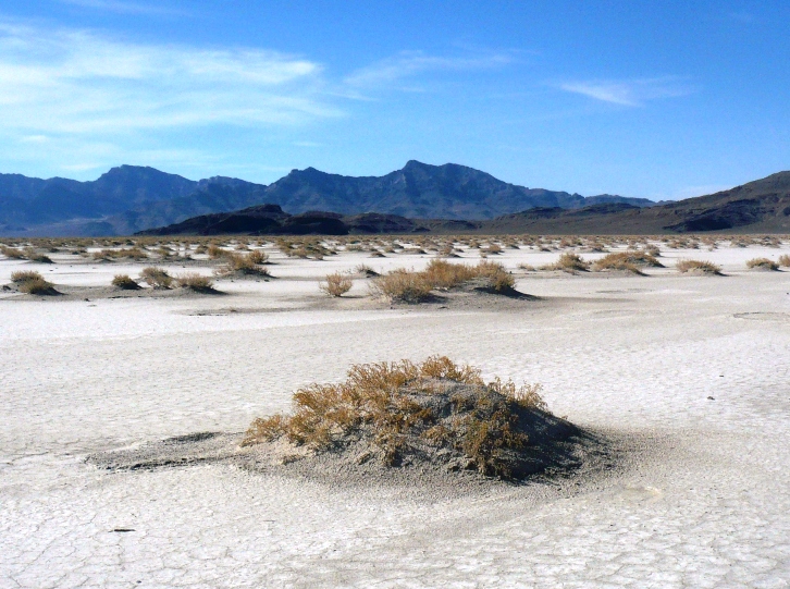
The Great Salt Lake Desert covers more than 4,000 square miles and includes the Bonneville Salt Flats which are an expanse of hard, white salt crust on the western edge of the desert in Utah. They are 12 miles long and 5 miles wide covering just over 46 square miles. Near the center, the crust is 5 feet thick in places. That is 147 million tons of mostly table salt! It is the site of some astounding land speed records over of more than 600 mph.

Surrounding the Salt Flats are miles and miles of Salt Mud Flats with various islands poking up. This was the site of the new Salt Flats 100 Mile Endurance Run. The course would run across the salt flats on Bonneville Dike, visit Floating Island, Silver Island, Donner-Reed Pass, and Crater Island. The race director Vince Romney described our island scenery as lunar landscape with a taste of salt. I thought that was a fitting description. The first men on the moon described that landscape in the sky as “magnificent desolation.” Indeed, all day and night, seven daring runners this year ran through “magnificent desolation.”

Despite its name, this run is not just flat. The course climbs up and over six passes along the way. Most of the course is pretty flat, but throw in over 5,000 feet of climbs makes it quite challenging.
I know that inaugural 100-mile races always have problems, but Vince decided to make the race free this year as he worked out the kinks. We had some good challenges along the way but we all finished, except Vince who had to stop running in order to make sure the rest of us had a great time.

Adding to our challenge, Utah was hit by a record cold storm. Some snow and fierce wind was forecast. This probably kept away a few runners, but seven of us chose to brave the elements and gathered at 7 a.m. on the Bonneville Dike, ready to run across the salt flats.
Jay Aldous went out like he was shot out of a cannon. I had tried to place his name and it took me awhile to figure out that he is the Kacina Mosa 100K course record holder, a very fast runner. His 8-minute-mile pace across the hard, rocky dike surface surprised me. I kept close for the first few miles but then decided he was totally out of my league if he kept that pace up and I watched him stretch his lead with every mile across the flats. He would go on to finish in an amazing sub-16-hour finish.
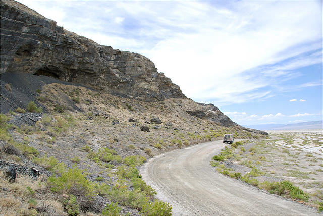
 The run across the dike to Floating Island is a major optical illusion. As you look down the road, it seems that it is only about three miles away. However, in reality it is 13 miles away. As you run, it seems to never come closer and it can really mess with your mind. I chose to not let it mess with me, and didn’t look down the road. Instead I looked to the left and right and enjoyed the amazing early morning views of the salt flats.
Running out on the mud flats this time of year isn’t a good option because your feet sink in about an inch or two making running slow and difficult. In 1849 explorer Howard Stansbury explained: “For a few months, in midsummer, the sun has sufficient influence to render some portions of the plain, for a short time, dry and hard: in these intervals the traveling over it is excellent; but one heavy shower is sufficient to reconvert the hardened clay into soft, tenacious mud, rendering the passage of teams over it toilsome, and frequently quite hazardous.”
We were running into a stiff, constant headwind of about 15 mph. Because of this challenging wind, early on I decided that I wouldn’t be trying for a sub-20-hour finish, but instead out enjoy the run and push for a respectable time, finishing before the next sunrise.
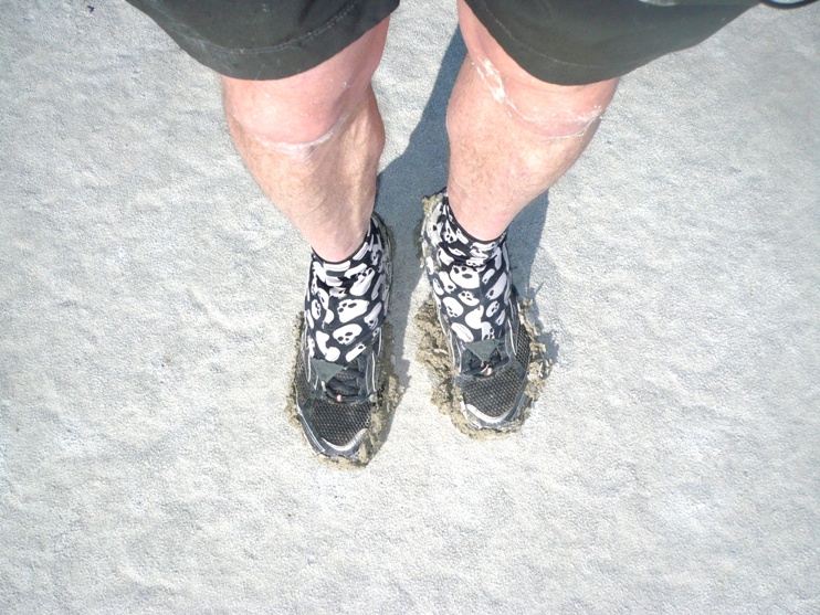
I was running in my new Bondi B Hokas. They were perfect on the hard rocky surface of the dike. In fact they would perform perfectly all day, letting me finish without any blisters or sore feet.
At about mile 7, I ran past the famed Floating Island Range. Not the typical mountain range you usually run by, but still an interesting range. Looking behind me, I could see my new Quebec friends, Andre and Emmanuelle about a half mile behind. The sun came out and reflected off the mud flats giving us a nice comfortable morning temperature to run in despite the tough wind.
As we neared Floating Island, the landscape changed dramatically as sand bushes dotted the landscape around us. I made a quick stop at the 10-mile unmanned aid station to fill up and then started my run up onto Floating Island.
Floating Island is a lonely place, just a small mountain poking up out of the mud flats, once inhabited by Indians. There is a large cave on the island which we ran past, but didn’t visit. Caves used by Indians in this area have yielded carbon dated material 12,000 years old. This cave was excavated by Archaeologists in 1986 and has been classified as a major find. It was an Indian “Motel” just an overnight stopping place, without any water, used for protection while they were traversing this region.

As I ran around the island I caught sight of Jay now over two miles ahead over on Silver Island. I arrived at the wide dirt scenic by-way that circumnavigates the island at the 2:52 mark. This was mile 18.7. My pace was faster than expected by 18 minutes.

Running north again, after a nice stop at another unmanned aid station, I continued running and making my way around the north side of the island. I passed a historic sign marking the route of the Donner-Reed party on the Hastings Cutoff in September, 1846. I could clearly envision their great difficulties getting across the mud flats. It took them six days to cross the Great Salt Lake desert. Four of their wagons and many of their animals were lost. Virginia Reed, a member of the ill-fated company recorded about a day in this area, “We traveled a day and night & another day and at noon pa went on to see if he could find Water, he had not been gone long till some of the oxen give out and we had to leave the Wagons and take the oxen on to water one of the men staid with us and the others went on with the cattle to water”
It finally dawned on me that I had not seen a course marking since arriving on Silver Island. I knew Vince had put markings at every 0.3 mile. Could I be going the wrong way? I continued to have an internal argument with myself about this. As I did, I slowed down significantly. I concentrated hard to find a course flag, but there were none to be found.

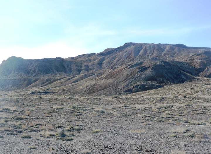
My next challenge was that a storm arrived with dark clouds over Cobb Peak (elevation 7,021 feet) above me. The headwind increased to 30 mph with gusts over 40 mph. Snow flurries fell and I wondered what else we would be hit with. Thankfully things calmed down, but I was still worrying about the course.
Finally I could see cloud covered 10,700 feet Pilot Peak in the distance and what looked like Donner-Reed pass ahead. I could also see Crater Island to the North. I had to be going the right way. One of Ben Benjamin’s crew appeared on the road ahead and he assured me that I was going the right way. Because I had slowed down so much, behind me I could see the Canadians just a half mile behind, catching up.

I arrived at the Donner-Reed aid station (mile 29.9) at 5:05, still seven minutes ahead of schedule. My pace was just fine. Vince’s wife greeted me, and helped me refill. I let her know that there were no course markings. She mentioned that they were also missing on the other side of the island. Vince had marked the course a week earlier and it turned out that someone had taken a ton of time to remove all the markings for 75 miles of the course! Knowing this, I grabbed my GPS out of my drop bag. It would now be my guide. I had marked waypoints for every turn and junction.

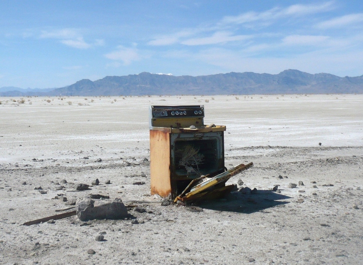
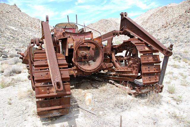
I now headed north toward the very desolate and remote Crater Island. This island once had much tungsten mining activity and there were plenty of things to see along the way. The course made a detour to visit a remarkable graveyard for 1950-60s cars and tractors.
I didn’t see any footprints on this detour and knew that Jay had missed it. I think only Ben Benjamin and I ended up going that route.
In the next valley, Jay came running swiftly down toward me, already on his way back to Sliver Island, more than six miles ahead of me. He was looking great. I made my way up our first major climb, up over a pass below Crater Island Peak. The views of the salt flats down below were an incredible sight to see. I had thought that the aid station would be at the top of the pass but it wasn’t there. I checked my GPS and discovered it was still a couple miles away down on the other side of the island. I was hit by a deep feeling of remoteness. As I looked around me, it seemed like I was running off the end of the world. I gazed to the north and could what looked like a flat white frozen ocean going off the end of the world.
There was no one around, I was all alone. I can’t think of another time when I was hit by such a remote feeling during a run, even more remote than the depths of the Grand Canyon. Magnificent Desolation!
I continued on and soon could see a lone vehicle down in a valley, flashing its lights in greeting to me. I arrived there (mile 37) at 6:48. It turns out this aid station was a mile too close causing our course to be two miles short. The guy there was very kind and enthusiastic. I had a quick stop, thanked him for being there and went on. I could now see the Canadians less than a mile behind me. That woke me up and I ran very hard and fast back up to the pass, waving at them as they went by. At the top, I greeted Heidi Bennett and we stopped to talk for a minute. She was doing fine but also concerned about the course markings. I assured her that she was going the right way.
I pushed on ahead, now motivated to extend my lead on the others. Near the car graveyard, I saw Ben coming down from it. We also stopped to talk. He had been all confused and had turned back several miles early, knowing that he was going to miss many miles on the Island. I’m sure he didn’t want to be out there alone. He decided that he would try to make up the missing miles on Silver Island. I wished him well, ran on ahead and returned to Donner-Reed Pass aid station (mile 44.5) at 8:20. I was surprised that I was only eight minutes behind schedule. (I didn’t realize that the course was two miles short). Vince’s wife informed me that Vince dropped out of the race in order to remark the course for us. I was very sad to hear that.

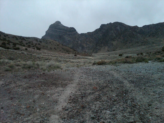
Next up was a tough 22-mile loop involving a 1,000-foot climb up Donner Canyon around Cobb Peak. I needed to finish this loop before sunset because my flashlight was back at Donner-Reed pass. The climb up Donner canyon was desolate, but amazing.

Vince had told me that there were many caves in this area that had been used by Indians thousands of years ago. Many Indian artifacts retrieved here were now in Utah museums. Fossil remains are found readily on the mountains. My progress was rather slow as the road was filled with deep gravel. I looked up around me and could indeed see caves up in the cliffs.

My stomach rebelled against the hard climbing and wouldn’t let me push the pace hard. I looked down behind me in the valley but could not detect the Canadians or Heidi below. But I could see some amazing views of the Salt Flats below.

Up ahead of me was a remarkable peak towering above. Soon I reached the top of the pass and now enjoyed a fast run down the other side to connect with the Silver Island Scenic By-way.

The next ten miles covered the same route I ran earlier in the morning to Donner-Reed Pass. It was somewhat annoying running this section again because the headwind was again fierce. But I was treated to see a lone antelope galloping within 100 feet of me, a beautiful sight.

About a mile from the aid station, I looked back and thought I saw Heidi down on the road about a mile back. (I was mistaken). That lit a fire under me. I was amazed at how much speed and energy I had if I really wanted to use it. I clocked a 10-minute mile.
I arrived at the aid station (mile 66.4) at 13:25, before sunset. A scout troop had arrived to camp for the night and man the aid station. I was their first runner to arrive and they looked at me with great curiosity. I was in good spirits but didn’t stay long, fearing that someone was on my tail.
I started off running fast, now heading south grateful to have a tail wind again. Vince drove up at dusk and reported that the rest of the course was now marked. I ran the next 7 miles pretty fast but then ran out of gels. With no more calories to input, my pace slowed. I watched the lights of some vehicles far across the mud flats to the west at the base of Pilot Peak towering above.

I arrived at the next aid station (mile 77) at 16:00, 11 p.m. Vince and his wife had driven there to take care of me. They fed me some nice soup and helped me to find new energy. I commented that I was surprised that I could not see any lights behind me. Vince mentioned that the other runners were probably now about two hours behind. OK, I was on my own for the rest of the race. Jay had already finished. Vince commented that he could see my green light from far away.
I now was faced with the last set of hard climbs, I would need to climb up and over the island and back, over eight miles and about another 1,000 feet of climbing. I made it to the top in pretty good time and now could see the lights of the trucks far away on I-80 crossing the salt flats. Down on the other side, I eventually found the ATV road to take back. I worried for the rest of the night that Heidi and the others might miss that turn. Glow sticks were badly needed. The ATV trail back, was a nice change of pace, but seemed to climb forever. Making things worse, I had a headwind in both directions. I was getting very cold. I had put on a garbage bag for some more warmth, but it wasn’t enough. The temperature was approaching freezing and the wind-chill was in the 20s. This caused me to get very drowsy and I started to stumble around. I finally found a place out of the wind and lay down for about five minutes to finally rest my eyes and legs.

On my way again, I finally reached the steep downhill crossing over the island again, heading down to the west side. Some car lights appeared — my next aid station. I desperately needed to get warmer. When I arrived at the car, I discovered that the guy was fast asleep. That was fine. I jumped into the car next to him, scaring him to death, and he kept apologizing for not being awake for my arrival. Vince had called him with my ETA but his alarm didn’t go off. I totally understood, it was 1:30 a.m. and it wasn’t like a stream of runners were coming through. He turned the car on and for the next ten minutes I just sat there and enjoyed feeling the heat warming my tired bones.
Finally I needed to leave. The guy was so very kind to me, offering to cook me up stuff and taking care of me. I reloaded gels from my drop bag and was ready to go again. Out in the cold wind, I immediately started to shiver again. As I ran down the road, I eventually discovered that I had left my hand-held water bottle in the car, so I ran back shouting and the kind guy heard me and brought the bottle to me.
Now, all was quiet and dark on the road ahead. I was in the home stretch, just four more uphill miles to a turn and a short climb up and over a low pass and about six more miles to the finish. On the south side of the island I could now see the truck stop across from the finish all lit up and inviting. But it was somewhat demoralizing to realize that I still needed to do a two mile detour to run down to by the freeway and run along the frontage road to the finish. I had to stop several times to check my GPS because I just could not see the flagging. Vince later realized that glow sticks were really needed in this section, but I finally figured it out. As I was running along the road to the finish, I looked back up to the pass and could see some lights heading my way. Were the other runners now behind me? No, it was a car. It was Vince driving down to see me finish. He arrived just seconds before me. I finished in 21:36:10. Vince let me know that the other runners were at least four hours behind now. I hoped that they weren’t getting lost and he assured me that he was helping them through the rest of the course.
I felt amazingly great at the finish with very little soreness. I was glad to finally stop running but felt like I could run many more. Why did I feel so fine? The cool temperatures? My somewhat easy pace? My Hokas? I don’t know, but my 40th 100-mile finish (actually 98 miles) was in the books. Vince learned a lot as a rookie race director and I’m sure will work out all the kinks to put on a first-class race next year. This is such a unique setting for an ultra, one that everyone should experience. I’ll be back.
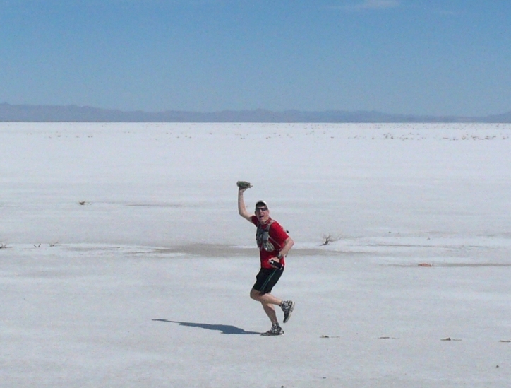
 Vince presented me with the most unique trophy that I have every received for my second-place finish. A hunk of salt from the Great Salt Lake!
Great race report as always. I felt lonely just reading it – Magnificent Desolation indeed. Sounds like those Hokas are worth the $.
Another memorable race in the bag. Thank you for the awesome details and congratulations on the finish.
True revival of our first and epic 100 miler.Challenging terrain and RD Vince has a good one in his hands.You guys were impressive for us “Canadian rookies”.Still can’t figure out how Jay pulled it off so fast,amazing.Salutations from Quebec.See you next year.
Andre/Emmanuelle
Great details. I wished I could have done it this year as my first 100, but I didn’t find it until too late and already scheduled a race too soon after. I will be considering next year, but it will be my second 100.
Nice write-up. It made me feel cold just from your description.
“Magnificent Desolation” I love the sound of that. I’m now definitely interested in checking this event out. This and your Pony Express 100 are on my very short list. Going to be tough to figure out what to run next year! Congrats! It’s good to hear you’re having great success with the Bondi B’s, I just got a pair myself and they worked really well for the 41.2 mile road race I just did. I just wish they’d make it with a more aggressive tread outsole and perhaps with a more high friction rubber so the bottoms won’t wear out so fast. Perhaps the next generation?