

The highest peaks in Utah are found in the Uinta mountain range, but the most impressive peaks that rise from the valley floor to the sky are found in the Wasatch Front. In 2012 Jared Campbell had summited the highest three Wasatch peaks in one day. I considered if it was possible to summit the four highest Wasatch peaks in one day. I knew I could do it. If I was going to do four, why not the highest six because the other two were nearby. That was my quest for this adventure.
You can define the highest peaks in several ways. I chose to use a 300-foot prominence definition. If you have two peaks close together, there must be at least 300 feet of descent between them to count the lower peak as a ranked peak.
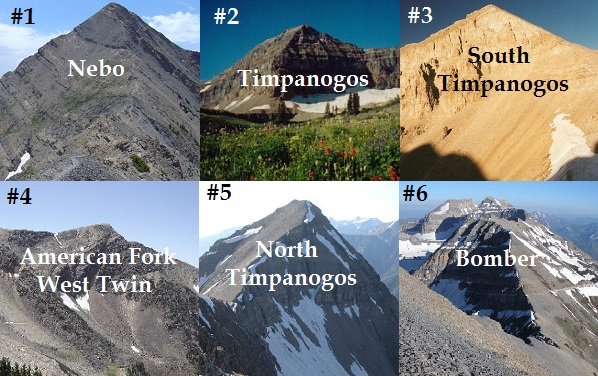
| 1 | Mount Nebo | 11,928′ | Above Nephi |
| 2 | Mount Timpanogos | 11,750′ | Timpanogos Ridge |
| 3 | “South Timpanogos” | 11,722′ | Timpanogos Ridge |
| 4 | American Fork Twin Peak – West | 11,489′ | Above Snowbird |
| 5 | North Timpanogos | 11,441′ | Timpanogos Ridge |
| 6 | “Bomber Peak” | 11,347′ | Timpanogos Ridge |
To pull this off requires car shuttles between the three locations (because they are far apart). I knew I would have to summit during the night, so this was my strategy:
- I would first summit Mount Nebo in the light. It had been almost 15 years since I had been on this summit and I did not remember the trail, so I would time my summit to be near dusk so I could get familiar with the trail going up during the light.
- Summit the Timpanogos ridge peaks during the night. I was very familiar with much of this trail, more comfortable with it in the dark.
- In the morning go summit the West Twin Peak above Snow Bird ski resort.
I debated whether to postpone because of the rainy weather, but the forecast and recent radar maps indicated that I would have a window of good weather, so I decided to give it a try. As I drove toward Mount Nebo, I could see a huge storm near the mountain but to the west was good skies.
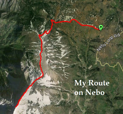
I arrived at the Mount Nebo trailhead above Payson Canyon and was on the trail at 6:30 p.m. The round trip for this summit was only 9 miles, but there was about 4,200 climbing involved during the round trip. I had the trail totally to myself. While this is the highest peak in the Wasatch Front, it gets far less attention compared to Mount Timpanogos.
The trail was in great condition, damp and soft from the rain, but not muddy. The trailhead is above 9,000 feet so I could feel the attitude immediately. There were some good runnable sections but other sections were steep and reminded me of Bozung Hill at Squaw Peak 50. Once up on the ridge toward the summit, there were some pretty exposed sections with cliffs on both sides, but the trail was fine. With about a half mile to the summit, dusk arrived and I turned on my light. Within minutes, the trail I was on ended. I had taken a wrong turn. I looked up and decided to scramble back up to the ridge where the right trail was. This worked out at first, but soon I was in a very precarious position on loose scree, ready to spill me down the slope towards the cliffs. This was pretty scary, but I backed off, found a better way up and eventually made it back on the right trail.
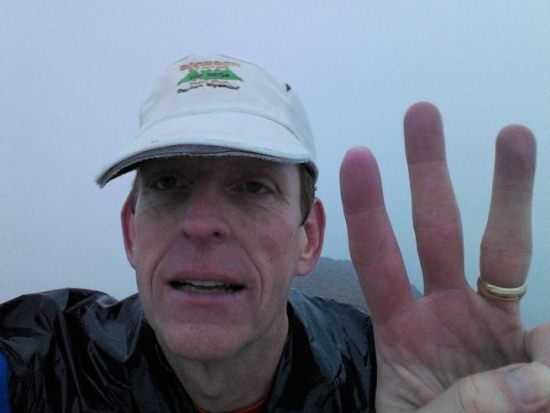
With that delay I pushed on toward the summit and arrived there in just under two hours. I didn’t stay long and began my descent in the dark. Looking down, I could see lights far below on the trail and they noticed my green light. I eventually came upon a group of guys trying to start a camp fire. One guy asked, “Don’t tell me you are running the whole thing.” I just ran by quickly and replied, “yes.” I arrived back at my car at 3:36. #1 summit was in the books.
I was in no hurry, I wasn’t really going for a fastest known time. I just wanted to complete my quest. In Payson, I stopped at McDonalds and feasted on a big burger to give me energy for the next summits. After about a two-hour drive I arrived at the Timpooneke trailhead and prepared to attack the Timpanogos peaks.
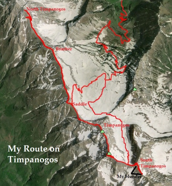
It was midnight and I had the trail to myself. This would be my 78th career Timpanogos summit, but I had never summited the other peaks. Within a half hour, the rain started. I put on my trusty garbage bag and that worked great to keep me warm and dry. It poured at times but only lasted for about a half hour. I decided that as long as I continued to stay warm, I would continue, but I worried what it would be like on top of the ridge.
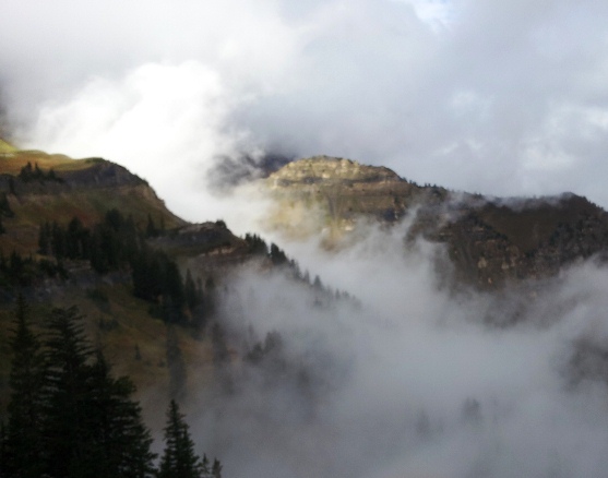
I soon received the answer as I reached the top of the ridge (the saddle). Thankfully the recent rain had not fallen on the ridge, but because of the low clouds I was in a thick fog. Usually you can see the spectacular lights of the valley, but all I could see was darkness below. At the saddle, instead of heading toward Timpanogos summit, I took a right and followed a trail I had never been on before which would take me two miles north along the ridge top to Bomber Peak and North Timpanogos.
At first the trail was nice and fast but then disappeared and I had to run on the ridge top and try to find the best route away from the cliffs to my right. Because of the fog, this was a challenge at times and slowed me down greatly, and my stress went up. My green light was great, but could not pierce the fog ahead far enough. I would be running on the ridge and come to a halt because ahead of me would be just darkness. At times it was a drop-off, so I had to take great care, back away and take another route. Eventually I did figure out that the main trail (only lightly used) was nearly always on the west slope, just below the ridge. I reached the high point on the ridge which must have been Bomber Peak, at the three-hour mark since the trailhead. Yes, my pace was terribly slow on the ridge.
Next up was a 500-foot descent and 500-foot climb up to North Timpanogos. I lost the helpful trail at times and did some climbing in the scree but reached the summit fine. Next, I would retrace my route to the south to go summit Timpanogos.
But on my descent from North Timpanogos, I became confused in the fog. As I was coming down, I concluded that I was following the wrong trail. I believed the correct one was to my right. So I traversed around the North Timpanogos slope but never found the supposed trail. Because the city lights were obscured below, I was totally turned around and going down the wrong slope. Finally I noticed that the wind was at my face which I knew was from the northwest. Wow, I going down the west slope instead of the south slope! So, I angled back up and eventually found the trail again. It had been a long delay.
Now on the right trail, my route was good and fast. I now was familiar with the route and even with the fog could do some good running. Back at the saddle, I was now on very familiar ground and made my way to the Timpanogos Summit. The summit hut was soaked from recent rains. I took a quick picture of me on the second highest summit.
Next, I was again on an unfamiliar trail to take me to the top of the Timpanogos Glacier area. With all my summits, I had never come down that route. Still dark, I made several wrong turns because of side trails that took you up to various views. The trail wrapped around the mountain ridge top and as dawn was arriving I became totally stumped as the trail ended. I headed back, shining my light down the slope and eventually discovered my blunder. If only I could see through the fog to see the peaks, it would have been much easier to navigate.
I reached the saddle above the glacier and was amazed that even now in the light, I could not see South Timpanogos Peak. But it was there on the other side of the saddle and I started to climb the steep slope. There wasn’t much of a trail, just some boot wear and I did poorly staying on the best route going up a rugged slope of loose rock. At times it was very rough and hard, but eventually I made it to the summit, now on the third highest Wasatch peak.
I worried about the steep descent on the loose rock, but as I went down, I stayed close to a ridge which was a much easier way down. Well, it was much easier because it was the wrong way. With the fog, I again had been totally turned around and was heading down a ridge to the south instead of returning down a slope to the west. I still could see nothing very far ahead in the fog, but could hear some automobile noise down below, coming from the wrong direction. I knew I had to go back up and I did. Once higher up, I was still stumped. The slopes all looked the same, which way was the right direction? I wished I had a compass. How many times would I need to descend to find the right way? I had visions that I would be up there all day lost in the fog. I pushed around the slope to the north and eventually found familiar ground and some boot wear on the rocks. I was relieved when I became certain that I was going the right way and quickly descended back down to the glacier saddle.
At this time of the year, there is not much of a glacier/snowfield left. But I decided to go ahead and take this route down. The bare slope was very steep and I fell several times but soon made my way to a massive rock/boulder field that in the early season is covered by snow fields, and is easy to cross. But this time of the year was a very slow tiring rock/boulder hop and the rocks were very loose. My pace was painfully slow and my ankles became bruised and my hands bloody from falls. It would have been smarter to backtrack clear to the saddle and go down the way I came up. But I pushed on.
Finally I made it through the massive boulder field and arrived at Emerald Lake where some campers were breaking their camp for the morning. The rain again fell for about a half hour. With all my long delays, I knew that I would no longer have time to drive to Snowbird for summit #4. So for my return trip I took my time and enjoyed the morning. I greeted all the many people making their way up the trail. I passed by Timpanogos legend, Ben Woolsey who recently completed his 600th lifetime summit. Even on bad weather days, people still make this trek up the mountain.
I reached the trailhead and my car. My crazy adventure was over. I had been able to summit five of the highest six Wasatch peaks. With all my wrong turns, I traveled about 31 miles and climbed nearly 12,000 feet. It was far tougher and slower than I had expected, but now with knowledge of the route, I know I can do it again much faster, and get that summit #4 too, and I’m sure I will, but this time without the fog and rain.
| Nebo trailhead | 0:00 |
| Nebo summit | 1:56 |
| Nebo trailhead | 3:36 |
| Timpooneke trailhead | 5:35 |
| Bomber Peak summit | 8:38 |
| North Timpanogos summit | 9:35 |
| Timpanogos summit | 11:40 |
| South Timpanogos summit | 13:00 |
| Timpooneke trailhead | 16:27 |
You have perfected the art of both insanity and inspiration. Way to beat out the weather.