Periodically I like to insert “repeats” into my training. I will select a difficult day hike and see how many times in a row I can do it in, at a much faster pace than hikers. Not only is this a good physical challenge, but it is a significant mental challenge. My theory is that if I can toughen up myself mentally too, when times get tough during a long race, I will be less likely to quit. Instead of quitting, you figure out how to continue on with a memory and assurance that with adjustments things will improve. With “repeats” it is easy to quit because you come back to your starting point, which is a way out toward rest and comfort.
For me, the rules for summit repeats include starting at an established trailhead, climb to the summit and then return to the trailhead. Then do it again, and again. Past repeats I’ve accomplished have included my repeats on Mount Timpanogos, the most consisting of five consecutive summits (24,000 feet of climbing in 70 miles). I’ve also accomplished Kings Peak (highest peak in Utah) repeats, accomplishing two consecutive summits, which I have done on three different occasions (9,000 feet in 52 miles). All three times I hoped to do three summits, but just didn’t have the mental push to run it one more time. Behind my house, I did four consecutive summits of Lake Mountain (12,000 feet of climbing in 36 miles). Others have tried to match or beat some of these accomplishments, but so far the records are safe.
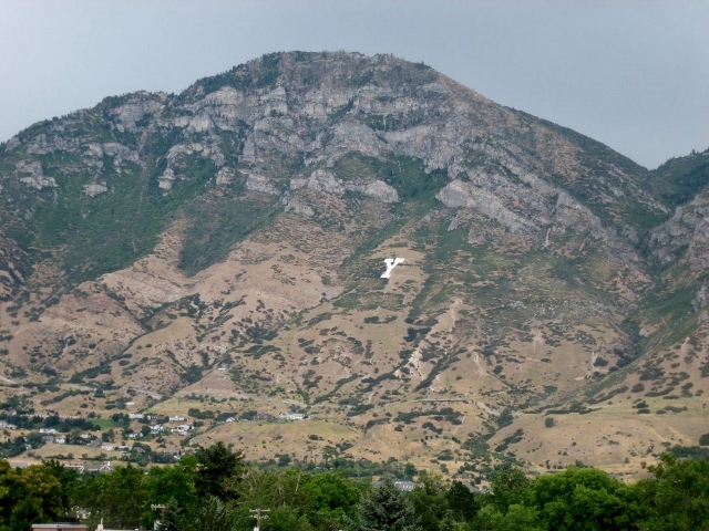
As the snow melts from the tops of the mountain and late spring arrives, I shift my training from long runs on lowland terrain to climbs into the mountains. This Saturday I was interested to start doing some serious vertical training and I selected Y Mountain above Provo, Utah, as my destination for doing repeats. See good article on the Y mountain trail.
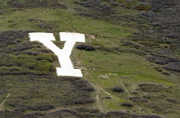
Y Mountain’s original Native American name was Wahdahhekawee, meaning “Blessed Mountain.” In 1906 plan were put into place to paint a “BYU” on the mountain to recognize the school down below. The next year, a bucket brigade consisting of thousands of students hauled up gallons of whitewash and only a “Y” was ever completed. It is now made of concrete and is 380 feet high and 130 feet wide. Several times during the year, the massive Y is lit up at night to celebrate various school events.
When I was a little boy in the 1960s, my grandparents lived up in the foothills on Y Mountain. My grandfather served as president and vice president of BYU for many years. When we would come to visit from Salt Lake City, we at times would “hike the Y” starting from their home. Back in those days the trail to the Y was rough, steep, and narrow, but as children we would make it up and enjoyed scrambling on the white concrete stones. Once I wanted to go higher, not knowing that there was a trail to the top of the mountain, I just hiked straight up above the Y until steep cliffs stopped my route. The views were amazing.
Nearly 50 years passed. I had never hiked the Y since those early days, until this month. Memories were rekindled. I discovered that there was indeed a trail to the top, so I decided I would finally hike to the top of the mountain and then do it over and over again, all in one morning.
My plans were to do the first trip in the dark with my flashlight and then do the next trip as the sun was rising. I arrived at the trailhead at 2:30 a.m. There were quite a few cars in the parking lot at this early hour, but it looked like they included couples “looking at the city lights” much too late into the night. I should have knocked on a few car windows asking if they wanted to join me on my run. I was on the trail (alone) at 2:42 a.m. The first section up the mountain is to simply “Hike the Y” on what now is a wide maintained trail hiked by students and families daily to the top of the block Y.
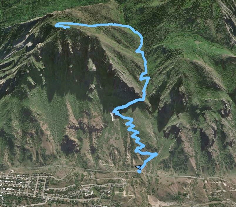
A bright moon was out and I had no need to use my light as I ran up Y trail that includes many long switchbacks. I was cheered on by thousands of crickets chirping in the pleasant cool morning. I reached the top of the block Y, the one-mile mark, and 1,000 feet in 24 minutes. (The record for this segment on Stava is a speedy 13:01 by Jon Lee). I now turned on my green light and continued on the single track trail which would take me into Slide Canyon, and then to the top. At the one-hour mark, I reached a trail junction at 2.4 miles and after 2,400 feet of climbing. I took the trail to the left to take me to the top. Gone were the helpful switch-backs and for the next half mile was a grinding climb through forest, aspen groves, and meadows.
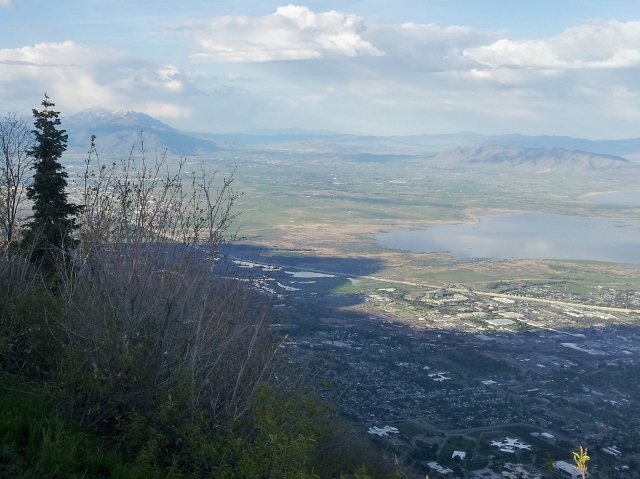
The trail took me to the top (8,527 feet). This isn’t the true Y mountain summit which is further to north and a few feet higher, but without the spectacular valley views. I chose to do my repeats to the more popular overlook. One trip up was about 3.4 miles and about 3,450 feet of climbing. I made it to the top in about 1:33, not racing it, but a good pace. The fastest time is less than an hour.
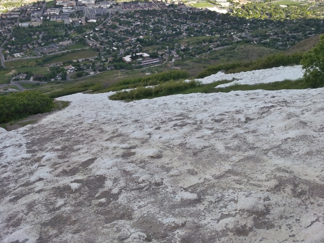
In the dark, I nearly stepped on two guys in sleeping bags right on the trail. A smoldering campfire was nearby. I went to the edge of the ridge and took in the amazing view of city light below. After tightening my shoe laces for the steep run down ahead, I again went by the guys and one of them woke up to see my strange green light.
The run down was great fun but steep. Thankfully the trail isn’t very technical and doesn’t have many rocks to try to trip me. As I reached the “Hike the Y” trail a few early eager hikers were making their way up the trail in the early dawn light. I finally reached my car again, the first trip taking 2:37.
I was feeling a little sore after the first trip, my quads and hips, but nothing bad enough to make me stop. I dropped off my flashlight, jacket, gloves and filled two water bottles for the next trip. My fueling was pretty simple. Ensure in one bottle and in the pockets a little candy and a gel. The other handheld bottle was water. I like to travel very light, with only what I really need.
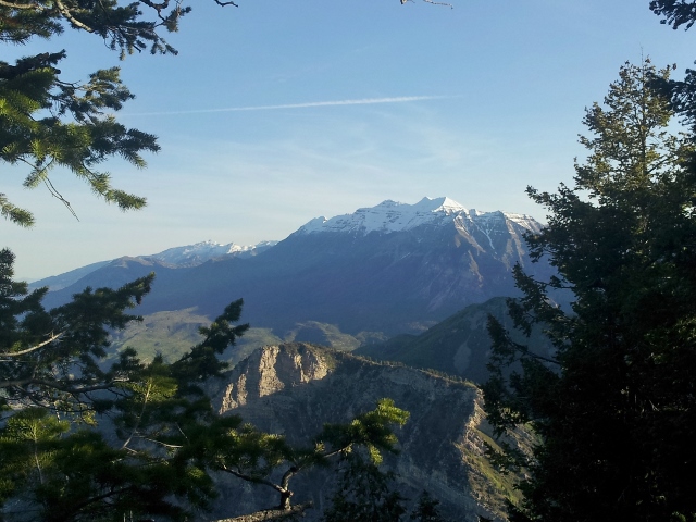
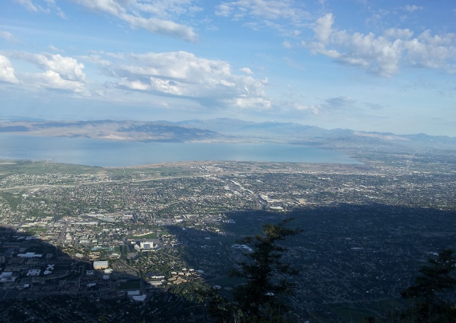
Trip 2 went fine. The guys camping at the top came down as I was going up. The morning sun started to hit the high peaks and the birds were out singing. I took pictures at the top, taking in the amazing views. I could look across the lake towards my home, many miles away. My run down was speedier now that it wasn’t dark, about 45 minutes. I ran fast by a couple groups camping who watched me speed down the trail.
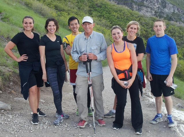
When I reached the top of the block Y, I saw my friend, Ben Woosley surrounded by young hikers. He called out my name and I greeted him. I discovered that he had just completed his 400th “Hike the Y” in less than three months. In the past two weeks hiked more than 100 trips, each about two miles, and 1,000 feet climbing. Ben is now 73 years old but very fit. He also holds the career record for Timpanogos summits (689). Last year he hiked to the top of Timp an amazing 72 times at age 72. I was really happy that I was able to witness his historic 400th Y hike.
As I arrived back to my car, I tried not to consider that I was only half-way done. Trip 2 (including stops) was accomplished in 2:31, and was faster than the first trip. I was starting to feel the toll of all the work, but there were no thoughts of quitting. I looked forward to quickly getting back on the trail to catch hikers going up and down and seeing if they recognized me. My stop was about nine minutes.
The morning was getting warmer, but the sunshine was still not reaching the eastern slopes so the trip up was still very pleasant. The “Hike the Y” trail was now filled with college students and families, out for a morning hike at about 8 a.m.
On the way up for Trip 3, I greeted Ben and his fans making their way down. My pace was still pretty strong. I made it to the top of the block Y in 29 minutes. But on the steeper sections ahead, my legs and energy started to complain. After all, I had now climbed nearly 10,000 feet. A hiker who had seen me coming up last trip recognized me, stopped me and asked in surprise, “round two?” “Actually this is round three,” I replied. His eyes went wide and he said, “That is awesome!” Others coming down weren’t as observant. A couple did double-takes, looking at me, but didn’t say anything. I can only imagine what they talked about after we parted.
Trip 3 seemed slow, but with a good downhill pace, it was 2:39, just two minutes slower than Trip 1. What was amazing is that I finished this trip feeling fantastic. My energy level was high and the legs felt great. There was no doubt that I would continue on for Trip 4, but I did look forward to finishing this off.
It now felt hot. It was 70 degrees, but in the sunshine on the slope, sweat started to pour off my face as I tried to jog sections up the trail. A couple runners coming down recognized me and congratulated me on my effort going up what they thought was a second run to the top of the Y. “If they only knew” went through my head. I reached the top of the block Y for the 4th time this morning in a still solid 30 minutes.
As I continued on, I was stopped by a hiking group, one with a lady dressed in a Wasatch 100 shirt. “Are you Dave?” a guy asked. It was Rett Thorpe who follows me on Facebook. I’m amazed how people can recognize me. It was good to meet him and they were doing a long hike up, over, and down Rock Canyon. I explained what I was up to and they were impressed. It was good to get encouragement from them and we wished each other well and I ran on fast ahead.
A couple other hikers coming down recognized me, asking me, “Going up again? On trip 2?” If they would have just asked, “Going up again?” I would have responded, “Yes, I left my wallet at the top.” But I responded with, “Believe it or not, Trip 4.” The eyes go wide and the mouths fall open at that point. I chuckle and continue on. The final push to the top was slow going with several short rests for a few seconds. I was very glad to reach the top. I had accomplished it! Four trips to the top!
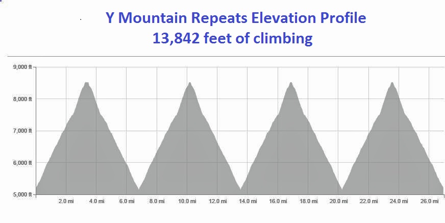
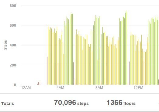
I took it easy running down, now knowing every stretch and turn well. I reached the bottom after a 2:55 Trip 4. In all, including my stops at my car, my adventure had taken 11:20:52. I had traveled about 27 miles and climbed about 13,842 feet. There was no fanfare or cheers at the bottom. I silently congratulated myself with a warm feeling of accomplishing something that I had set off to do. When times get tough during a future 100-miler when I want to quit, I’ll think back on these times of mental toughness and will likely continue to push on.