 I made a return trip to the Uinta Mountains for another very long Saturday run. Dry August weather makes it an ideal time to experience the high mountains away from the valley heat. I hoped for to do a long loop of about 50-miles and decided to start very early in order to give myself plenty of time on the rugged slow trails.
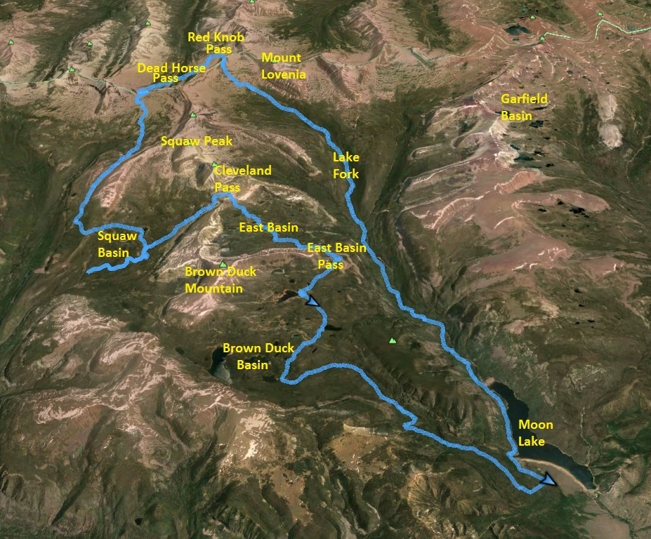
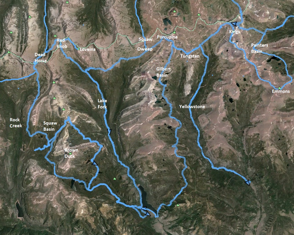
I arrived at Moon Lake on Friday evening and decided to just rest at the trailhead in my car for a few hours. At 11:53 p.m. I was away on my nocturnal adventure. A nearly full moon was out to cast light on the hills around me. For the first 16 miles, I would be running in forest up Lake Fork, starting at 8,000 feet. Getting off trail in the dark was not a real worry because the horse-worn trail was very distinct and easy to follow. I had run 16 miles last week in Lake Fork and knew what to expect on this mostly boulder-free trail.
In the first mile, the trail took me on the boundary of the campground and some late-night campfires were still roaring. I suspect the campers wondered about my bright green light as I ran swiftly past them. I love the peace of running at night. All was quiet at first as the trail traversed up the canyon high above the lake, but soon I could hear a dull roar of the river pouring into the lake. The winding trail continued high above the river gorge. My main obstacles were getting through marshy areas from side streams, trying to keep my feet dry.
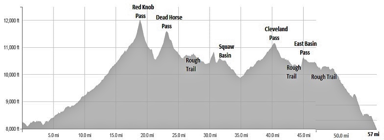
The trail made a pretty constant climb and would climb for about 4,000 feet in 18.8 miles to Red Knob Pass. I covered the first five miles in 1:05, a strong pace for a climbing Uinta trail. But progressively my pace would slow as the trail became rougher and the obstacles slowed me down more. Since last week, I detected that dozens of horses had went up and down the trail, chewing it up quite a bit.
At about 2 a.m., it was getting cold enough to stop to put on a long-sleeved layer and pull out my gloves from my small pack on my back that I used to carrying my food. I only carried one hand-held bottle which I would refill from safe-looking side streams. Thus far for years I have had no ill-effects drinking unfiltered side-stream water in the High Uintas.
I reached the Highline trail at mile 14.7 after a little more than four hours at 4:07 a.m. At some point I paused for my breakfast of a burrito and some candy. Thus far, I had followed the trail well and at only one point had to hunt around for a minute to find the right continuation point. At about mile 16, at 10,800 feet the trial broke out the tree line and ran up grassy slopes. It was now a challenge to stay on the faint trail on the grass in the dark because large trail cairns could not be seen at a distance even with the bright moon and bright flashlight. At one point I totally lost the trail and had to run a large loop until I found it again.
Soon I lost the faint trail again, but this time used my memory of the other two times I had run this section of the Highline Trail at night. I knew that it really didn’t matter how you ran up the grassy slope, as long as you ended up at the correct point to climb up Red Knob pass through its boulder slopes. Using the moonlight, I figured out which peak was Red Knob and set my sights on a point to the left. Soon I stumbled on the trail again and did a better job staying on the correct route.
At mile 18.2, at about 5:30 a.m., I arrived at the base of the switch-back trail to the pass. I recalled one year at night when I couldn’t find this point at all and resorted to climbing boulders slowly most of the way to the top. But this time, I went straight to the correct point knowing that if I saw a small lake behind my left shoulder that I was at the right point.
As I climbed up the trail carved through the boulders I heard barking. At first I thought it was a pack of coyotes and I barked back, but the barking was coming toward me fast. They were sheep dogs and they didn’t like my green light at all, nor my barking in reply. They stopped below me, not knowing where to go up the trail to follow and barked furiously at me down below. As I continued to climb higher, they eventually calmed down and returned to their flock. In the distance I could hear the clicking of bells on some of the sheep.
At 6:00 a.m., after a little more than six hours of running and 18.9 miles, I reached the top of Red Knob Pass at 12,015 feet. Dawn light was arriving but it still was pretty dark as ran down the other side of the pass. As it reached the grassy slopes below, it still was too dark to see the large cairns marking the way. I knew it really didn’t matter, that I needed to run down the slope and make my way to Dead Horse Lake at the base of Dead Horse Pass which I identified correctly. After 1.5 miles off trail, I entered the forest trees and knew I was too high, so I simply headed straight down until I found the trail and continued on.
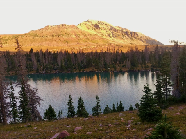
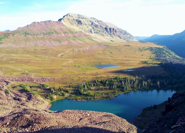
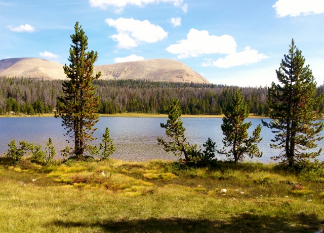
At mile 22, at the 7:30 mark, I arrived at beautiful Dead Horse Lake. All was quiet as I stopped for another breakfast, watching the fish jump in the lake. The early morning sun was peeking over the ridges to shine on the slopes across from me. It was still too chilly to take off a layer. I had been running through some frosty grass. As I made the climb up to the pass, I spied three backpacker tents on the other side of the lake but no one was up yet. I tried singing loudly to see if they would hear me but no one stirred.
I reached the top of Dead Horse Pass (mile 23.1) at the 8-hour mark. The views in the early morning light was amazing. I absolutely love being in very remote areas watching the morning come alive. I recalled that back in 2010, I had left my camera at the top of this pass. It stayed up there for several weeks, but a kind hiker had found it, checked the pictures on it, and by searching the Internet used detective work to find out that I was the owner.
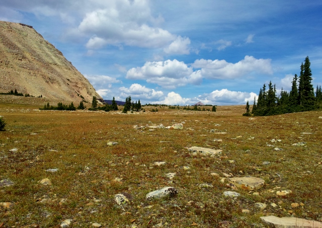
From the top, you have to run across a ridge to find the continuation down. Down below the pass, I entered a very cool area with large boulders scattered across the valley. I knew that I needed to leave the Highline Trail for a trail to Squaw Basin that I had never run on. I thought I missed the junction and took out my notes and small map to consult. I concluded that the junction had not been marked so I decided to just again head down a grassy slope until I found that trail. (I actually had not yet arrived at the junction.)
I had great fun just making my own route, descending through a beautiful grassy valley with some lakes. Yes, I had uneasy feelings because I wasn’t on a trail in a new section for me, but I trusted my skills and headed in the direction that I thought the trail should go. My notes mentioned that the correct trail would pass by Phinney Lake at 10,600. Checking my Garmin watch, I could see that I was still much higher so that trail point was still far ahead.
As I headed in the direction where I thought the lake would be, I stumbled on the Squaw Basin trail at mile 25.0. The trail was distinct with many horse prints and was well-marked with cairns. I felt relief to now have a trail as it was entering the forest again. I had not wanted to bushwhack through trees.
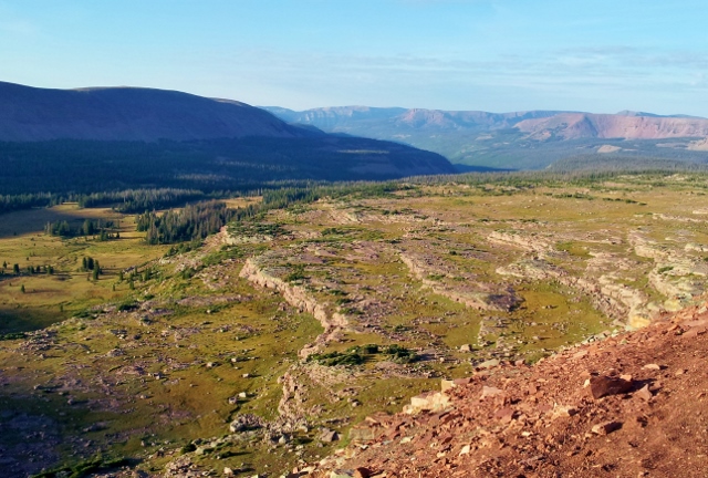
For the next several miles I ran on a high shelf above Rock Creek below. I understood well why this was called Rock Creek valley. The trail became very rough and slow with boulder obstacles. My pace slowed significantly and my energy drained from the hard work. I passed by many small lakes and eventually went up and over a ridge at mile 30.6 and descended down to Squaw Basin.
From the high ridge, I looked back up the massive Rock Creek Canyon back toward the High Uintas.
Looking across the basin, I could see familiar Brown Duck Mountain, a mountain that looks like a dead duck lying down. I had run around that mountain a couple years ago so was reaching familiar territory again.
The morning was getting warm and I took a trail across the basin and stopped for an early lunch at Squaw Lake (mile 32.1) at 11:07 (11 a.m.). I rested for about ten minutes looking at the quiet lake. I had expected to see others along the way, but thus far I had not seen a single human on my adventure.
As I continued on, I reached a junction. I now needed to decide if I continued on my intended route to go up and over Cleveland Pass, or to bail out at this point and cutting my adventure short by 5-7 miles. I decided to cut it short and turned right.
As I continued, I hoped that there would be a junction to connect with a newer Two Ponds trail, not on maps, that I knew went along the base of Brown Duck Mountain (I had run on the trail a couple years earlier) But no junction appeared. After two miles, I was convinced that I needed to turn back. A junction that my map did indicate had never appeared and I was heading in the wrong direction toward Rock Creek. I turned back. (Actually, the junction was only a couple hundred yards ahead!) My pace quickened on the uphill as I was full of energy, trying to make up lost time. I kicked myself for wasting the time and four miles. I tried a bushwack to find the Two Ponds trail, but just couldn’t find it. (At that point it was further up a slope.)
I arrived back at the bail-out decision point junction, and headed toward Cleveland Pass. Soon I arrived at a clearly marked junction for the Two Ponds Trail. OK, should I again try to bail or go for the distance? Now feeling strong, I decided to not wimp out and continued on the climb to Cleveland Pass. I was at mile 38.8 and my legs loved running the uphill trail fast so I pushed the pace.
I arrived at Cleveland Pass (mile 40.2) and connected to the trail that would take me down to East Basin. I was at the 13:48 mark. Now above the tree-line again, going over my third major pass, I had great fun running fast down the grassy slopes. Instead of running in the horse rut trail, I chose to just bound down the nearby grassy slopes.
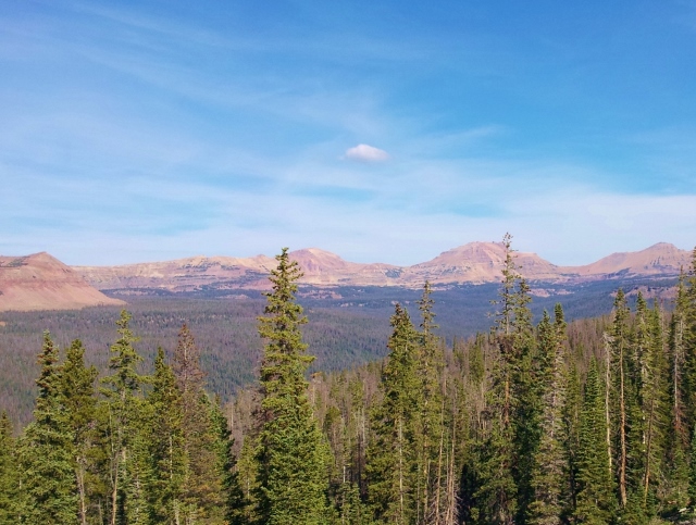
Back in the trees again, in East Basin, running by several lakes, the miles were getting to me. I was getting anxious to finish now, but there still was 14 hard and rough miles to go. So it turned into a mental exercise. Instead of focusing how many more miles there were, I shifted my mind to other things and just enjoyed being in the mountains for the afternoon. My goal now was to just finish before dusk.
The trail turned very rough and I could feel a hot spot starting on the bottom of a foot from all the uneven running. I made my way four miles across East Basin and arrived at the bottom of steep switch-back to the top of my fourth pass. I probably wasn’t drinking enough at this point and was low in energy. I took a seven-minute stop to try to regroup and then struggled to the top. I arrived at East Basin Pass (mile 45.9) at 15:38.
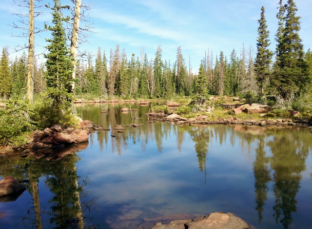
The next four-mile section is one of the roughest and rockiest trails in the Uintas. It took me by some beautiful lakes, part of Brown Duck Basin, but I was anxious to finish. I finally arrived at a junction for the Brown Duck trail which would take me back to Moon Lake. I was at the 50-mile mark at 17:20. It didn’t seem like the 50 miles were that slow, but I knew that running in the Uintas is always slow, even when it seems like you are going fast.
The next two miles were the worst boulder infested trail, worn by horses and erosion which reminded me of the crazy stock trail at Capitol Reef 100 a couple months earlier. My feet were not happy and again I had to use mental strength to not count the miles left, push the pace, look around me and try to enjoy the rest of the day.
With four miles to go, the dirt road lost its boulders and was smooth and maintained! My legs came to life and I ran faster than 9:00 pace for the first time in many hours. I loved the flying feeling as I quickly descended down the trail. Moon Lake came in view far below and I knew my finish was near.
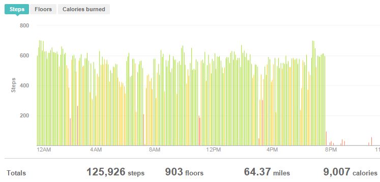
After a couple more miles, the trailhead and my car finally came into view! What an adventure! I had beaten dusk by about 45 minutes. I had traveled nearly 57 rugged Uinta miles in 19:40 and climbed about 9,000 feet along the way, crossing over four passes and through four major basin areas. I crossed over more than 100 streams and by several dozen lakes. The training felt good. My legs weren’t sore and I know this helped me further to get ready for Wasatch 100 in a couple weeks. I had spent about 15 hours working very hard above 10,000 feet and never felt any altitude effects. Best of all was the peace and solitude I experience the entire time. At no point on my adventure had I seen any other humans which was surprising on a late summer Saturday.
I love the Uinta Mountains. The High Uintas are only free of snow for about three months, so I try to get there each year. I estimate that I am approaching 1,000 miles of running in the Uintas.