

The Uinta Mountain range is the highest in Utah. Much of it is protected by Wilderness area. I enjoy running up in the high Uintas because of its remoteness and rugged beauty. Most hikers and runners who go to the Uintas, only go to the heavily traffic areas, Mirror Lake area on the far west, or Henry Fork in order to summit Kings Peak, the highest peak in Utah. However, they are missing much more beautiful sections, better trails, and more interesting peaks that are usually only seen by backpackers or horseback riders.
Weather is always a challenge. The Uintas are usually subject to significant afternoon and evening thunderstorms that can be very scary if you are high up. Finding key times when the weather is calm allows for much safer and more enjoyable periods to explore the high mountain region. This past week was such a time so I made plans for a new long run.
When you consider the Uintas trails, think boulders. Most of the trails run north/south up and down the drainages and the trails consist of imbedded boulders, obstacles for running, that have been exposed by runoff and years of horse traffic. In contrast, the Highline Trail runs east/west near the center spine of the range and crosses over many high passes along the way. I’ve run the Highline Trail end-to-end two times (once solo) but it requires convincing someone to help you shuttle a car or drop you off at the far end, a service that takes about eight hours. My family is now smart and declines when I ask for that shuttle help.
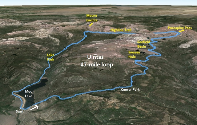
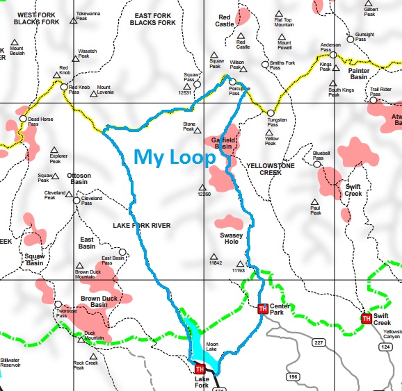
Instead of running the Highline trail, I decided to run a long loop that would allow me to run my favorite section of the Highline trail and also let me explore some areas I had never visited. I chose to start at Moon Lake on the south slope, a convenient location without any bumpy dirt roads to get to. It is about two hours from Utah County and consists of three trailheads to head west, north, and east.
I arrived Friday evening and camped at the very nice and large Moon Lake campground, turning in early to get at least a couple hours of sleep. I was on the trail at 1:23 a.m. starting my counter-clockwise loop at the dam, at 8,080 feet. I first ran along the east side of the lake on a smooth rolling trail but soon started a 3-mile 2000-foot climb. The trail was a typical boulder-strewn trail.
At mile 3.5 I reached a wide-open grassy field which in the Uintas are called “parks.” This was Cow Park and in the dark these sections are challenging because there is no worn trail across the grass and the cairns are so far apart and can’t be seen. I did my best and ran along an old wooden fence line, trying to figure out when the trail would again enter the woods. After 0.7 miles, I got lucky and stumbled on a cairn and again joined the right trail.
I carried with me my lights, one water bottle, and some food in a very small backpack. For water, I would refill from safe looking side streams coming from springs. I brought iodine pills if I needed to dip into a main stream, but I never needed to.
At mile 5.6, I reached the Center Park trailhead at 10,300 feet. (This trailhead can be reached by car). I had been running for 1:53 and had been struggling with low energy and feeling of sickness. For the past week we have had a steady wind from the northwest, blowing in smoke from a massive Washington wildfire, along with plenty of pollen. I was really suffering with sneezing, poor breathing, and itchy eyes. But I pushed on and hoped to recover. The smoke in the Uintas seemed to be much less than back home in the Wasatch Front. I took a ten-minute bathroom break at the trailhead that helped.
I now headed north on the heavily-travelled trail from the trailhead. It was generally easy to follow but I still took temporary wrong turns in the dark that were quickly corrected. Dawn came as I approached Garfield Basin which contains many lakes. The trail took a turn and seemed to be heading in the wrong direction, down to Garfield Creek. I stopped and convinced myself that I had missed a left-turn to continue north. (The junction was actually just 100 yards further ahead, around a bend). The map I had didn’t show enough details so I stopped, turned back and went around Five Point Lake hoping to find the trail. I didn’t and concluded correctly that I didn’t actually miss the junction.
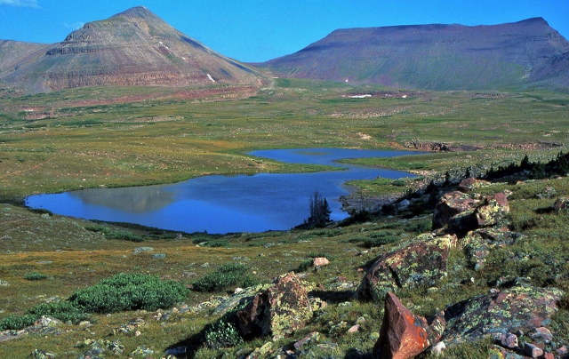
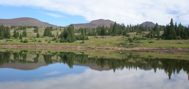
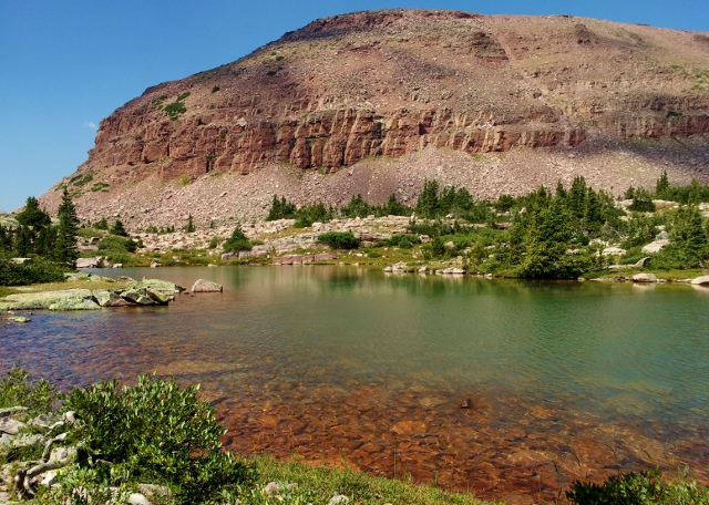
Instead turning around, I decided it would be fun to just make my own route. I generally knew where I was and knew my next destination was Porcupine Pass. I was above the tree line so it was very easy to make fast progress on the rolling grassy slopes with occasional stream/marsh crossings. It turned out that the route I took actually was a more direct route than the trail and probably saved about a mile. I had great fun exploring Garfield Basin going by Superior Lake and six other small high altitude lakes in the early morning sunlight.
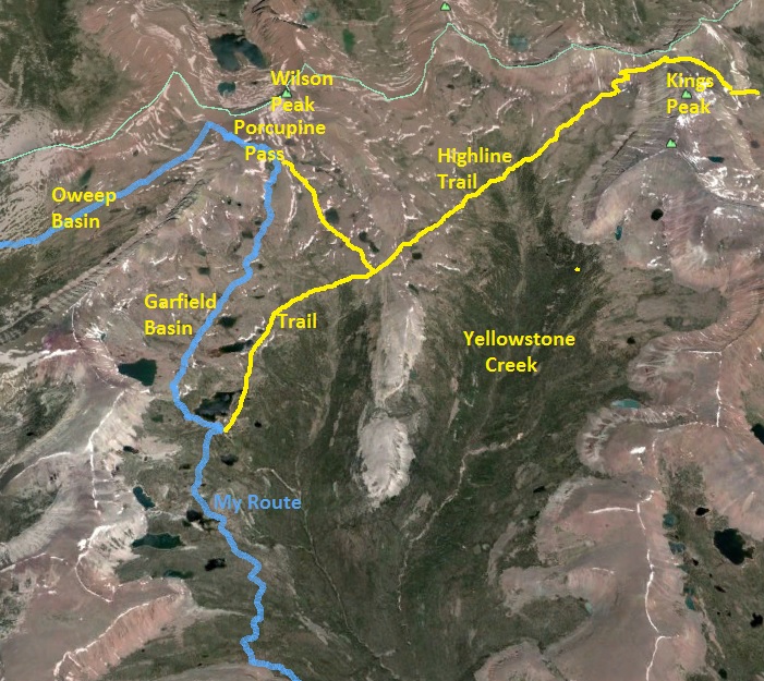
I concluded my adhoc route at mile 21.3 and 11,774 feet as I reached the Highline Trail below Porcupine Pass. I was pleased that my route worked well and that I had seen many new areas.
I reached the top of Porcupine Pass (mile 22.1, 12,221 feet) at 8:22. The wind was fierce, probably about 40 m.p.h. I previously had thoughts of summiting Wilson Peak above me, but the cold wind was just too much and it wouldn’t be enjoyable.
I wanted to get out of the wind quickly and started descending down the other side of Porcupine Pass. I was very surprised that the usually faint trail was wide, smooth, and very runnable. Halfway down I discovered the reason. There was a forest service trail crew doing great work on the trail. I didn’t stop, just exchanged greetings and continued on.
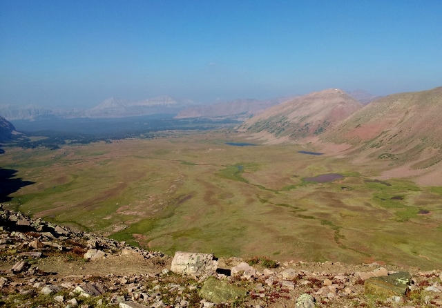
Down in Oweep Basin, the wind was now much calmer and I began a fun fast run down the grassy slopes. There were occasional huge cairns along the way to keep you on course. This was the fourth time that I had travelled through this beautiful valley.
At mile 25.6 I stopped to eat a second breakfast at 9:17 (10:40 a.m.). I sat behind a large cairn out of the wind for about ten minutes eating and fixing a foot problem. I thought about my progress. Originally I hoped to do a very large loop of over 70 miles that would take me over Red Knob and Dead Horse Passes, but to complete that loop, it would take me about 24 hours and I didn’t have that time. I decided that I would change plans and instead run down Lake Fork to Moon Lake.
Continuing on, I was really enjoying opening up the speed down the grassy slopes and soon reentered the forest. Besides the trail crew, I had not seen another human all day. I was at a very remote location on the Highline trail that was nearly 20 miles from any trailhead.
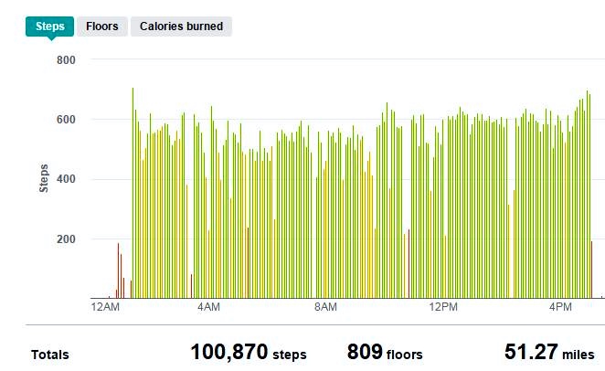
At mile 31.3, the 50K mark, I reached the Lake Fork trail junction. I was at the 11-hour mark. That seems very slow, but with the rugged trail and climbs and a few long stops, that was pretty good.
For the first time, I ran on the Lake Fork trail. I knew that it would be very long, 15-miles to the trailhead at Moon Lake. Because the trail is so long and forested, it gets little foot traffic, just horses. Long forested trails like this can be boring, just the same thing over and over again like a 1960s cartoon that repeats the background over and over again. Knowing this, I strived to notice the uniqueness of what I was running by and I really enjoyed the early afternoon run through the shady forest.
I was surprised by two things. First, this trail was mostly boulder-free. There were still annoying sections of obstacles, but they were short. Unlike other Uinta drainage trails, this one had long smooth sections where I could really open up the speed. Second, I was astonished that on the uphills, my legs just loved pushing very hard with high energy. Earlier in the morning I had really struggled on the uphills, but now 40 miles later, I was warmed up and feeling great.
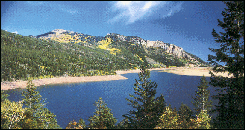
Moon Lake came in view and I ran on the west side up the lake on the well-maintained, smooth rolling trail. I realized that my adventure was nearly complete. While I was happy to be able to finally rest, I felt disappointment that my experience with the Uintas was nearly complete. I now came upon day hikers and some horseback riders. I explained to a couple of people that I was completing a very long loop of nearly 50 miles. I could tell from their reactions that they just couldn’t comprehend what I was doing.
I finally returned to my car, completing the loop of about 47 miles in about 14.5 hours. It had been an amazing peaceful adventure away from crowds.
Wonderful accounting of your run and adventure! I have only backpacked in the Uintas once and I enjoyed every step of it. Beautiful area. Thanks for sharing Davy.
I need to spend more time in the Uintas! I’ve only spend time in Henry’s Fork Basin and in the Grand Daddys. Thanks for the write up!
Dave,
You are amazing! I have hiked and backpacked all those trails but the stretch up Fish Creek from Moon Lake. I can’t imagine running that in one day. It would take me 4 to 5 days backpacking taking my time fishing and whatnot. I own the lodge at Moon Lake so next time you are there stop by and say hello. I’ll get a picture and put you on the “wall of fame”.