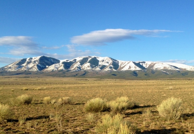
I guess I have a strange obsession with running around mountains and mountain ranges. Most people like to bag mountains by climbing to the top. I like to bag mountains by running around them. This Saturday I bagged another mountain range, the Onaqui Mountains in the west desert of Utah. These mountains lie south of the Stansbury Mountains (Deseret Peak) and north of the Pony Express Trail.
This loopy obsession began on May 2004 when I ran around the mountain behind my home, Lake Mountain, a loop of about 32 miles. That felt like an amazing accomplishment at that time. Since then I’ve probably run around it nearly 15 times. After that, for many of my solo adventure runs, I’ve chosen to run around a mountain or an entire mountain range. My entire list is at the bottom of this article.
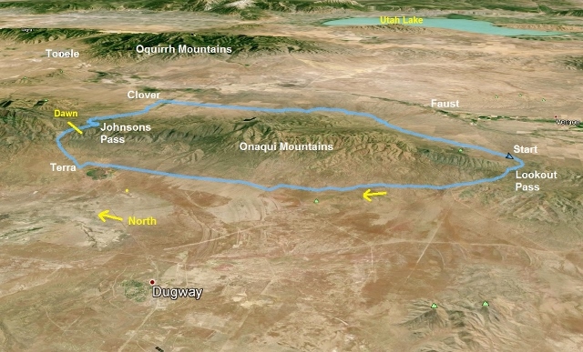
I began my run around the Onaqui mountain range at 1:44 a.m. Saturday morning about two miles east of Lookout Pass on the historic Pony Express route. It was about 47 degrees out, warm for this time of year. Yet as I began to run a soaking rain fell on me for a couple minutes. I looked up and only saw clear starry skies, so it was a complete mystery where the rain came from. I usually have an uneasy lonely feeling as I start these long remote solo runs, and the unexpected rain added to it, but after a mile I settled in and started to enjoy the night.
All was quiet as I ran up and over Lookout Pass and by the starting location of my Pony Express Trail 50 and 100. No campers were seen anywhere in the valley. At mile 3.9 I left the Pony Express route started my long trip north, on the west side of the Onaquis. Last year I had fun running the foothills and ridges of the Onaqui following various wild horse single-track trails. A herd of more than 100 wild horses live in these mountains and come down into Skull Valley near Dugway.
I could see the faint lights of Dugway ten miles off to the northwest as I ran north. The temperature cooled down into the lower 40s and so I needed to stop to put on gloves. A tailwind kept things mostly comfortable for me. As I ran forward, I became convinced that there was another runner or cyclist coming toward me about a mile away with a headlamp. It seemed to move and flicker but never came. It turned out to be a stationary light eleven miles away. With all my nights in the west desert I know how deceptive lights can be over these long distances but yet again, I was fooled.
Soon the lights of the little town of Terra, about ten miles to the north, came into view. I was heading toward that remote rural town. I could see some lights a little nearer from Hatch Ranch and was fascinated that all these lights never seemed to come closer. It would take me another couple hours to arrive. My pace was a consistent 11-mile pace on the rolling, but descending dirt road in the lower foothills. The road was fairly smooth, but had enough ruts to keep my attention in order to not trip. But after a while, I just let my feet feel the road and I watched the flickering lights off in the distance and the amazing stars above my head. The time and miles passed by fast.
Last year, I had run this road during the night but by dawn had arrived at Terra. This year, I reached Hatch Ranch (mile 16) in three hours, at 4:45 a.m. All was still dark but all the dogs in the ranch noticed me and started barking like crazy. I hustled away up the road and watched my backside to make sure a biting dog wasn’t following me.
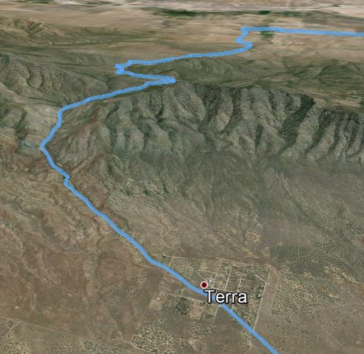
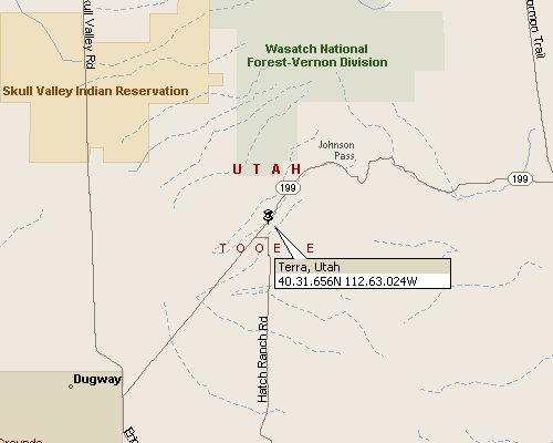
The town of Terra was all quiet and dark. I reached Highway 199 at mile 17.2 and my legs enjoyed the change to run on the pavement. I ran through town and then started the four-mile, 1,500 feet climb up to Johnson Pass on the northern end of the range. Dawn arrived as I approached the top and a few cars started to drive by on the way to Dugway. It became pretty cold, about freezing on the west side of the pass, but once over, I would feel warm air coming up from the desert floor.
In recent years there have been attempts to rename Johnson Pass to Fisher Pass in honor of Carl Fisher who founded the historic Lincoln Highway, the first cross-country automobile highway. He had donated personal funds for improvement of the pass nearly 100 years ago and part of the agreement was to rename the pass and put a monument there. For years it never was, but a monument was placed there in 2009 in his honor identifying this spot as Fisher Pass. All the maps still officially call it Johnson Pass which honors Luke S. Johnson an early Utah Pioneer who eventually pioneered the area. I choose to still call it Johnson Pass. Fisher, not from Utah, had a project funded there, but the Johnson family spent lifetimes nearby. I didn’t know anything about this history when I reached the pass and saw the monument. But the rename immediately struck me as inappropriate with likely controversy. I was right.
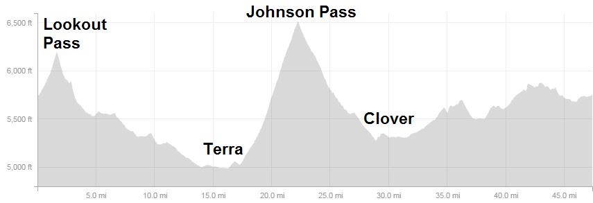
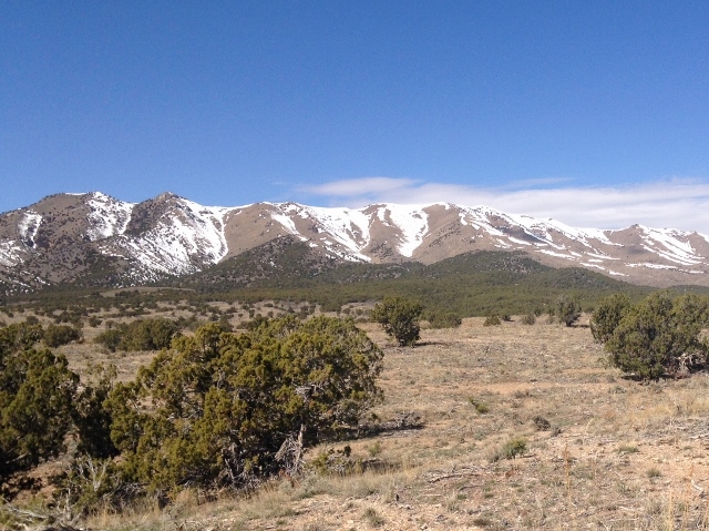
I carried with me only two water bottles but drank a lot before leaving my car. Now, after 20 miles and four hours, it was time to refill. Snow patches were plentiful above 6,000 feet. I stuffed my bottle with melting snow, and made sure before the patches disappeared that I had full bottles to make it to the finish. I did pass by a reliable spring, Clover Spring, with a campground, but there was a large scout troop camped there and I chose to not visit the spring.
I ran down the other side and come into the little town of Clover. I noticed the Johnson name prominent on mail boxes and on a massive ranch that was founded in the 1850s. I also saw fishing sites on Clover Creek that allowed the public to fish on Johnson land. It further made me wonder what outsider was trying to rename the pass to Fisher Pass with all this rich Johnson history nearby in the area. I pondered about carpetbagging as I ran along. It turns out that the efforts to rename the pass were championed by Rollin Southwell, a highschool shop teacher from Salt Lake City, and a Lincoln Highway history buff. The Lincoln Highway had been planned to be rerouted over Johnson Pass but the reroute was never finished. Southwell pushed hard and gathered funds to complete the monument to have the brief Lincoln Highway history trump generations of local Johnson history.
I made my turn south at mile 28.5 at the 5:48 mark. I ran by many rural homes and ranches curious about those who chose to live so remotely. I stopped to sit by the side of the road near a large ranch to eat my breakfast and take my only rest for six minutes. Feeling better, I continue on and I left the pavement at about mile 31. My loop had included 14 miles of pavement.
My chosen route could have been much tighter around the east side mountain range to reduce miles, but would have needed more bushwhacking, more ups and downs, and running on some private property. I was content to run a loop approaching 50 miles, wanting to get in a good last run to prepare for a 100-miler next Saturday.
Despite my detailed instructions and a little map, I took a wrong turn at about mile 35. I tried to adjust and get back on the right route, succeeding at times, but then again went off on other trails. I really didn’t sweat it because last year I had spent some time on this side of the range and in the distance could see where I wanted to go around the range. What is nice about running around mountains, you can’t get lost. So, I ended up exploring. At one point I found a wonderful wild horse single-track trail that was great fun to run on. Another time, I found a great fence line trail that took me on a nice direct route for about 1.5 miles. I bushwhacked at times and as it turned out, my route was 1.5 miles shorter than my planned route to stay on dirt roads.
My car came into view and I finished my 47.4 mile loop in 10:30. I felt great. It felt good to get in nearly 50 miles by about noon.
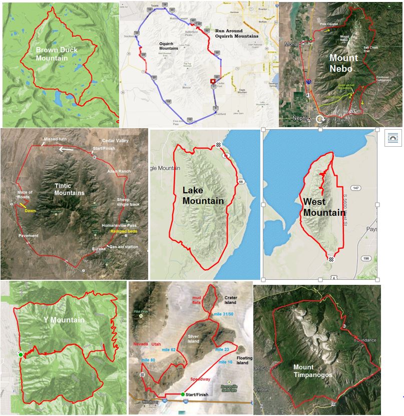
My collection of mountain loops include: South Oquirrh Mountains (62 miles), Onaqui Mountains (48 miles), Mount Nebo (47 miles), Mount Timpanogos (38 miles), North Tintic Mountains (several times 36 miles), Brown Duck Mountain in the Uintas (35 miles), Lake Mountain (about 15 times, 32 miles), West Mountain south of Utah Lake (twice, 24 miles), Mount Raymond, Gobblers Knob (20 miles), and Y Mountain (13 miles).
Additional mountain loops during races and backpacking trips include: Silver Island Mountains during Salt Flats 100 (100 miles), Cascade, Provo, Corral etc. during Squaw Peak 50 (50 miles), Tokawanna Peak, Wasatch Peak and Mount Loveniea in the Unitas (50 miles), Kelly Mountain, Cougar Mountain in Washington during Plain 100 (50 miles), Castle Peak in Idaho (30 miles).