

The San Rafael Swell is about 2,000 square miles of public land in Central Utah that is known for its scenic sandstone formations, deep canyons, and expansive panoramas. The entire area has been lifted up and turned, leaving an angled reef displaying amazing rock formations, domes of sandstone, and rugged ridgelines. The area is harsh in the summer and is often overlooked to visit except for off-road vehicle enthusiasts and horseback riders.
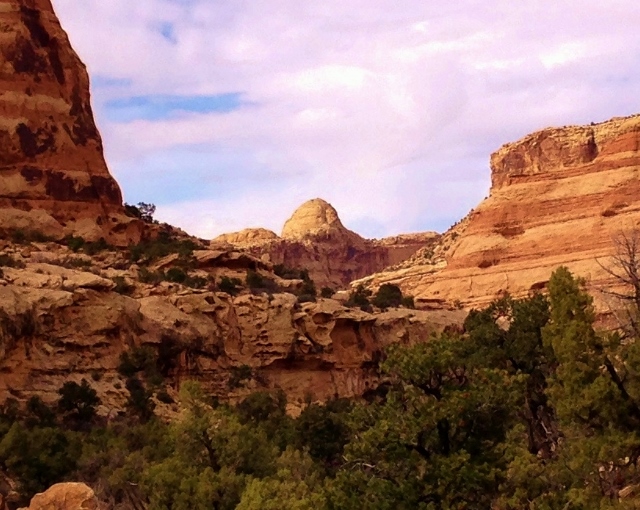
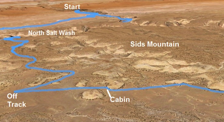
A Wilderness Study Area has been established in the Swell and this has been somewhat successful in keeping the ATVs out of pristine canyon areas and high plateaus, leaving areas of solitude. I was interested in exploring the Sids Mountain Wilderness Study area, a very remote area in what is known as the Little Grand Canyon of Utah. Late winter is an ideal time to run in the area because of the spring-like temperatures, some flowing water and lingering snow patches.
I planned to run up onto Sids Mountain (named after one of the Swell’s earliest ranchers, Sid Swasey), explore the very remote wilderness, and hopefully have time to run along areas of the south rim of the Little Grand Canyon which gets no visitors.
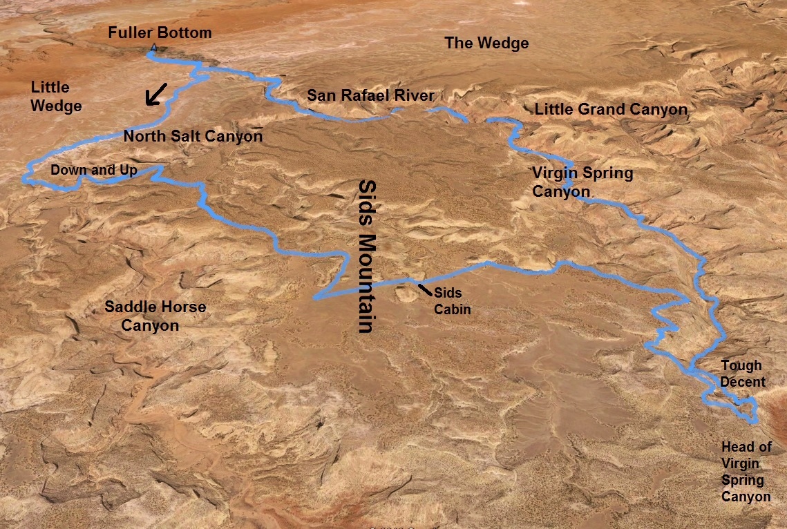
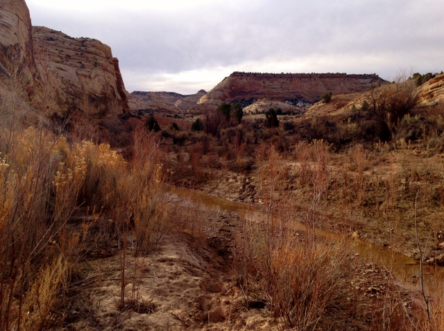
I began my adventure at sunrise, leaving my vehicle at Fuller Bottom on the San Rafael River where it enters the Little Grand Canyon. During the spring runoff, this is a popular remote spot to put in a raft to float about 12 miles through the canyon. First thing, I had to ford the cold river which was knee deep. I knew my shoes would quickly dry out.
I ran up “Little Wedge Road” a dirt road that ascended 400 feet during the first three miles to the rim of North Salt Wash far below, which was flowing with water. The road rolled along the rim presenting amazing morning views.
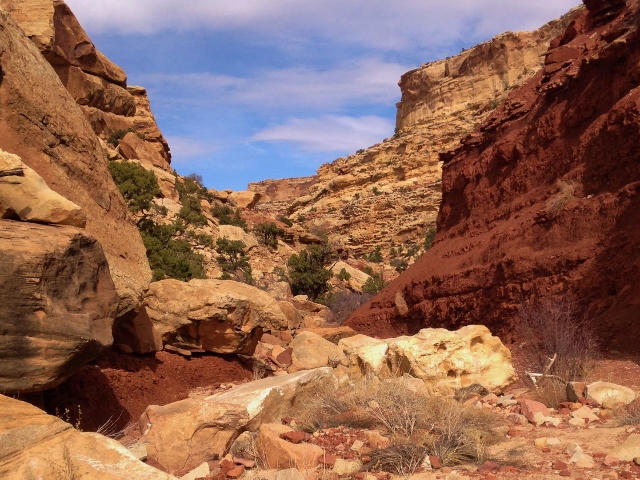
At 4.7 miles, I found the unmarked trailhead I was looking for, which would lead me down into the North Salt Canyon bottom. There was an old road, but no footprints to help show me the way. I trusted my directions. I soon came to an overlook and paused to figure out where the route continued to bypass cliffs to the bottom. There were no cairns to help, but I looked carefully and went ahead down a chosen route. A few cairns appeared to comfort me that I was headed in the right direction, descending steeply down 300 feet into the canyon.
In the amazing canyon bottom, I followed a horse/cattle trail down the canyon for about 0.7 mile and somehow successfully found a worn horse/cattle trail that nicely wound its way up toward the top of the mesa on the other side. Cairns at times helped me along my way up. At mile eight I was up on the other side of the canyon at 6,000 feet. My adventure had started at 5,260 feet. My pace thus far had been on the slow side, affected by my 21.5-mile Wedge run the late afternoon before, and by the rugged trail. It had taken me a little more than two hours to reach this point.
For the next three miles I ran through cedars gently climbing up towards Sids Mountain on a pretty well marked horse trail. At times I would lose it but again find it pretty quickly. At one point I discovered that I had dropped my map and directions. I paused. Should I go back and find it? Without it, my adventure would be more stressful, uncertain, with more wandering. I went back a quarter mile and thankfully found it. But then a couple miles later, I again discovered that it had dropped out of my pocket. This time I went back a half mile, knowing where I had last pulled it out. I search and searched but finally gave up. If I would have been a lot smarter, I would have included it on my phone or at least taken a quick picture of it when I had last lost it. But no, I now was truly on my own to use my memory of the route.
At mile 11.8, the trail turned east. I knew that I needed to go east but I actually turned a half mile too early and ended up following cattle trails. But my route took me into a beautiful open high plateau open area surrounded by sandstone domes and hills. My trail turned south, the wrong direction and I knew I was off course. At mile 13, I stopped and studied my surroundings carefully. I correctly concluded that I need to head further east across this Sids Mountain mesa.
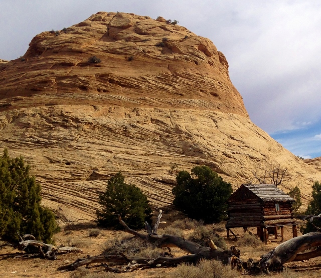
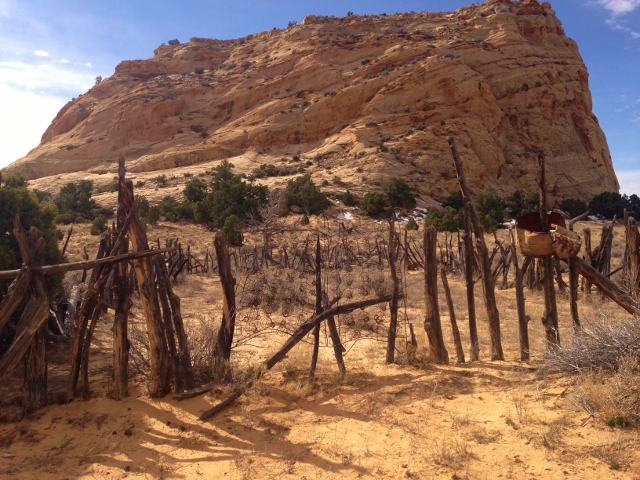
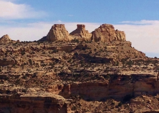
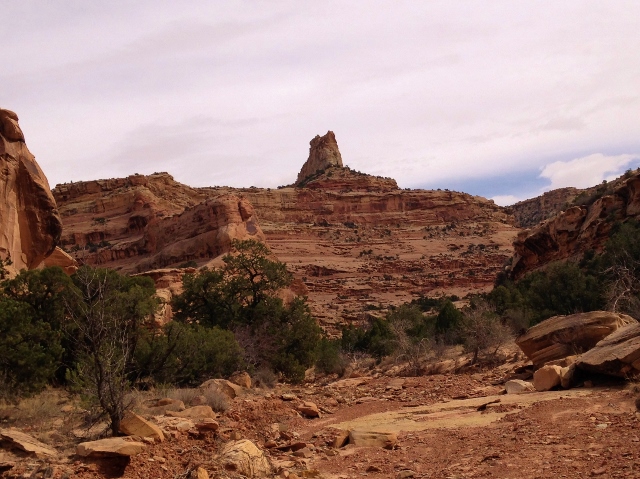
At mile 13.6, I was thrilled to see Sids Cabin come into view. I now knew where I was and wouldn’t have uncertainty of being off course. Sids Cabin is listed on the Utah State register of historic sites. For years the Swasey brothers had run cattle in the area and finally in 1921 built a cabin. This unusual cabin is raised on posts. It was in a beautiful area below sandstone domes.
I was now at the four-hour mark, going much more slowly than planned. I didn’t visit the cabin area long, feeling the stress of needing to get going faster. Now I had no trails to use, I was just running through cedar and open fields.
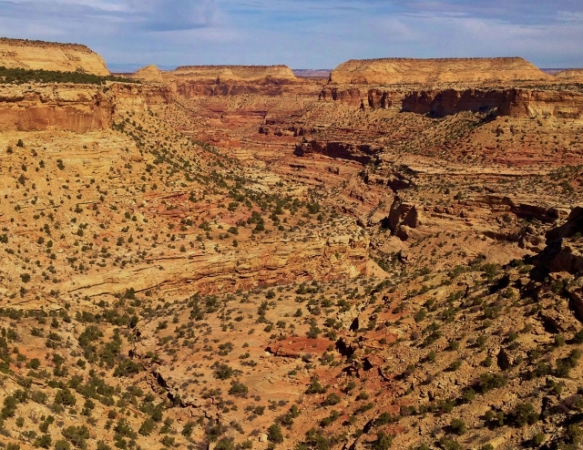
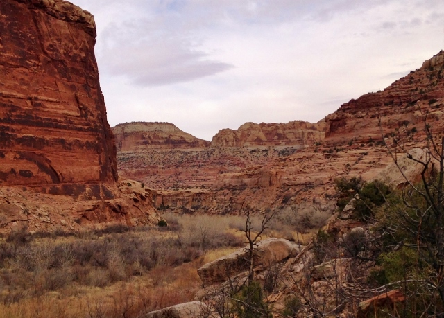
My next destination was the west rim of the upper reaches of Virgin Spring Canyon. I arrived and looked at the amazing canyon views. My plan was to run around the head of the canyon, over to the east rim and run on No Man’s Mountain along the rim.
But the head of the canyon was still far away to the south. The rugged area near the rim which was slow-going. At mile 16.4, on the rim, I could now see a possible route around the head of Virgin Spring Canyon to get to the other side. I was nearing the five-hour mark and still going pretty slowly. Should I continue on or head back? Each time I had that question in my mind, I decided to continue on.
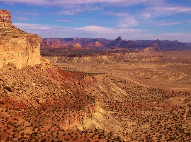
Near the top of the canyon was a vast slickrock mesa that was great fun to run on that rolled up and down. Finally at mile 17.9, at 6,500 feet, the highpoint of my adventure thus far, I reached a narrow area that connected the top of the canyon. I had a great view over the ridge to the east and could see massive Cane Wash out on the desert floor before it carved its way north through its canyon.
I had difficulty figuring out how to continue across this narrow area. It looked like it would involve a sketchy down climb. Here I was in a totally remote area, probably 20 miles away from another human in all directions. My approach on solo remote runs like this is to not face dangers, to stay safe. I had already taken a couple bad falls tripping and had scrapes and bruises. I didn’t want to have worse things happen. I backed off, but as I did, I found a safe route below that even had a cairn marking it. Someone else had traveled here before, likely backpackers.
I paused again. It was now 12:30 p.m. I had three choices. 1. I could turn back and have a fun run in familiar territory and would stay safe. 2. I could continue on and run along rugged rim routes that would slow me down, I would likely run out of time, and get into trouble before dark. 3. I could try to descend into Virgin Spring Canyon which would likely be faster, but would face uncertain obstacles like spill-offs which could turn me back up.
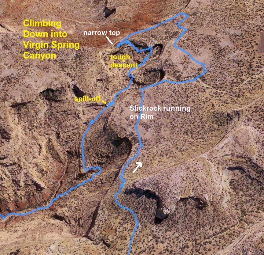
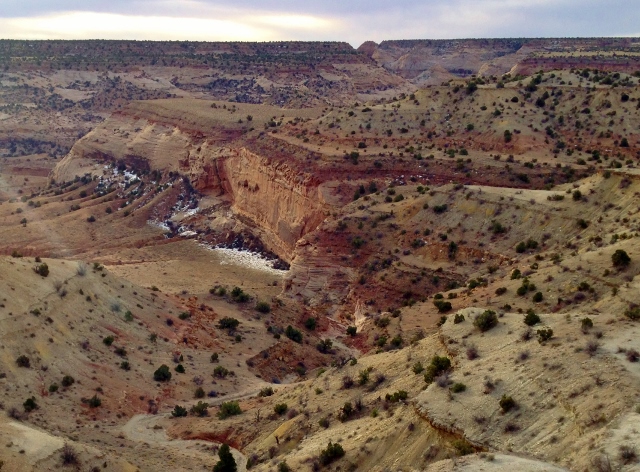
I chose to descend into the canyon. I had hoped for some cairns or some evidence that others had descended, but there was none. I took the safest routes possible, traversing slopes and at times thinking I would need to head back up when reaching very steep sections. But each time I found a route that worked and finally after a half hour successfully descended 400 feet to a basin and sandy wash to run in. But I knew I wasn’t out of the woods yet. I didn’t see any tracks of wildlife or humans. I knew I was still in a very isolated section of the canyon. I recalled seeing a massive spill-off earlier from up above. Was it ahead?
Sure enough, around a corner I came to a huge spill-off. It was now 1:00 p.m. If I turned back, I could reach my car by dark. I decided to first try traversing the western slope of the canyon to see if there might be a safe route lower. Stress was high because time was running out and I didn’t want to get into dangerous situations. In cases like this I’m so focused that I forget to eat and drink. Such was the case this time.
Thankfully, as I continued on, I saw that it was very possible to continue descending. Lower and lower I went with continued traversing. I had bypassed the spill-off but there still were others and boulder ridden blockages in the canyon bottoms. So I continued my travels on the slopes and finally after descending 800 feet in an hour and going less than two miles, I was fairly confident that I was “home free.”
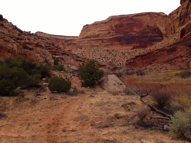
I felt very relieved. I had made it down a tough route from the head of the canyon and now was on runnable wash. I now saw wildlife footprints so I knew the way ahead would be good. There were no human prints up this high in the canyon.
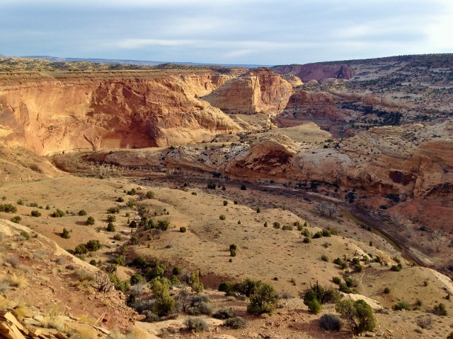
I had great fun running down through the Virgin Spring Canyon. The entire canyon would be 6.5 miles long. The canyon was very deep with the rims above rising more than 1,000 feet.
I faced a few more minor spill-offs but each time quickly figured out my way around and halfway down the canyon noticed a few human footprints that had been there for a while. I still had the canyon all to myself.
There were many obstacles to run around, pools of water, sandy banks, and boulder river bottom. It was all great fun and very beautiful.
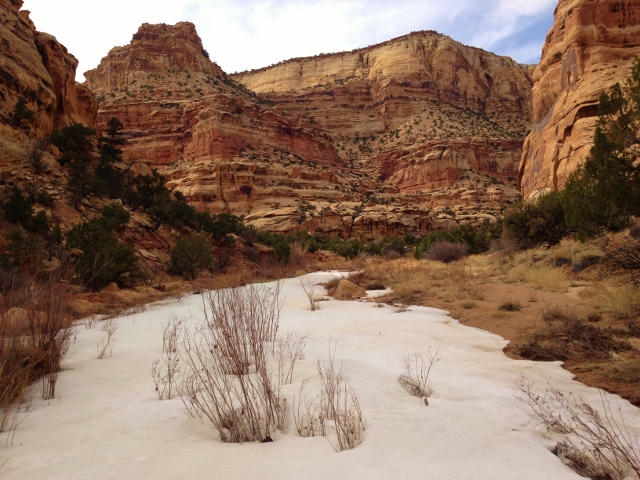
I was surprised to see long sections of the canyon bottom snow covered. I ran on the snow at times and soon water was flowing. With the rugged canyon bottom, maintaining a fast pace was hard to do. It took me nearly 2.5 hours to travel from the very top to the bottom, at the San Rafael River.
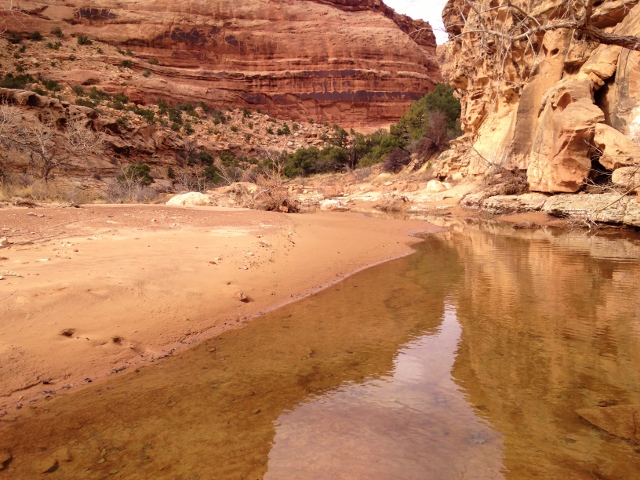
I arrived at the flowing river in the depths of the Little Grand Canyon. I was at mile 24.7 and I knew I had just six more miles of river trail upriver to my car. It was approaching 3:00 p.m. I had plenty of time.
I had never run through this section of the Little Grand Canyon. There is a trail, but it is soft horse/cow trail pitted with their prints. At times the trail would wind through river willows that scratched my legs and made the going slow. Other times the cows had created wandering trails, making it difficult to select the fastest routes. At times I had to backtrack.
There also were at least ten river crossings. They weren’t a big deal, just knee high. The cold water felt good on my tired feet and legs. I tried to push the pace, but my miles were at best 15-minute miles making my way up the river.
The high 1,000-foot rim started to descend and I knew that I was finally exiting the Little Grand Canyon. The trail got better and better the further I went and for the final 1.5 miles I bid the river goodbye and ran on good trail and eventually on the dirt road I started on.
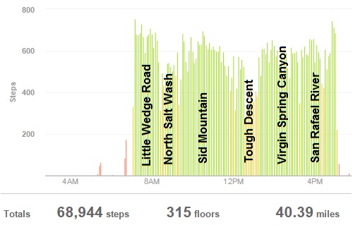
I arrived back to my car after being gone for ten hours, covering a tough 32 miles and climbing 2,800 feet. Wow! That was a tough, beautiful run. I had not seen a human nor any vehicle all day. It had been quiet and peaceful, but a bit stressful to be so remote by myself. But all went well and it was thrilling to explore the vast open high lands during the morning and run through the beautiful canyons in the afternoon.
Pretty cool!!!
Fantastic write up. I just did much of this loop as a 2 day backpack with my dog. I started at the Sids Mountain TH, headed up Sids Mountain and then descended into the West branch of Virgin Springs Canyon. I had a lot of anxiety about whether I’d get hopelessly cliffed-out far into the descent Virgin Springs Canyon. West branch does have a non-technical descent for a human, the dog had to be carried/belayed over a few sections.