

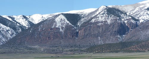
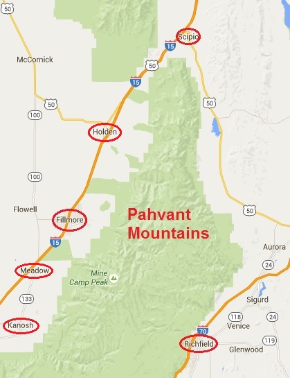
 For years as I would drive south on I-15 by Fillmore, I would gaze up at a particular mountain range after passing the small town of Scipio, Utah. This range presents a peculiar flat horizon on top and I would wonder and dream of running along the top of that mountain range end to end. In 2016 I accomplished this run from Scipio to Richfield, a journey of about 58 mies. This mountain range is named the Pahvant Mountains, after the Pahvant tribe, a branch of the Ute Indians. The Pahvant Range merges into the Tushar Mountains on the south.
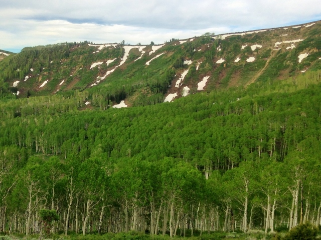
The Pahvants are rarely visited, mostly by ATV or horseback riders. A section of The Pauite ATV trail runs along a portion of the range. The range is about 44 miles long and 10 miles across. There are a number of peaks along the range over 10,000 feet high. In 2009, an ancient high-altitude Indian village site, named Pharo Heights, was discovered on the range top at 9,465 feet. The village was occupied between years 450-1300 A.D. It was likely a summer residence when the ridge was snow-free.
I really enjoyed my 2016 run on the range. Water is always a challenge so it is better to make the run while these is still plenty of lingering snow so early July is usually the right time. With the deeper snow pack this year, I thought a couple weeks later would work. I decided to take a different route this year. I would start from Scipio Pass off I-15, take the Scipio Pass Trail up to the top of the ridge and this time run all the way (58 miles) to Kanosh Canyon in the south. I would then run to the only motel in Kanosh to spend the night. The next day I would run the lowlands along the I-15 frontage road to return to my car, about 35 miles. Those were the plans, but they didn’t quite work out.
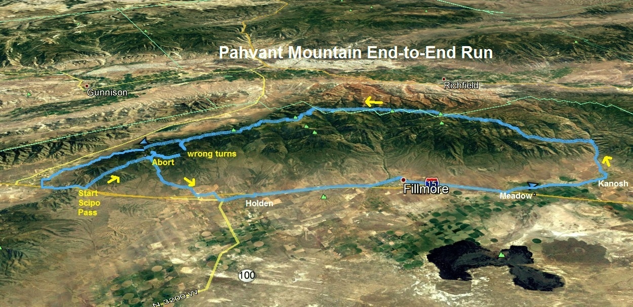
Thursday evening, I drove to Kanosh and dropped off a bag of old clothes and some food in a hidden place near the motel for the next night. I then drove back north to the nice motel in Scipio to get a few hours of sleep. I started my run at 1:31 a.m. at Scipio Pass, parking my car near the communication tower. I was a little worried that the trail would be hard to follow but was delighted that it was well maintained. I carried with me two handheld water bottles and a small pack with food and other items I would need along the way.
All went well for the first three miles until I reached a dirt road in a valley devastated by fire last year. I couldn’t figure out where the trail continued from there. I searched an area indicated by the topo map, but saw no signs of the trail. (I didn’t realize at the time that a number of years ago the Scipio Pass Trail was relocated to climb up 2,000 feet to the ridge top at this point. If I would have just followed the dirt road up, I would have been golden). I thought the trail needed to climb up and over a saddle ahead, so I just continued cross-country, hoping to find the trail. Soon, I did. It was a double track trail with evidence of recent travel by ATVs. I was so relieved and ran on. In another mile the ATV tracks stopped. It looked like they lost the trail. I searched and eventually found the old trail. There were no ATV or human tracks on it, just animals, but there were clear cuts through the trees. It was a navigation challenge but I did pretty well, going up and over the saddle and down into Goose Canyon.
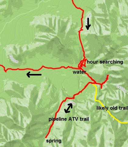
At mile 5.6 I totally lost the trail. I knew it was very close to the next road but the brush was too thick to continue. I was 51 minutes into my run. I knew where I was, I just didn’t know how to continue. For the next hour I searched and tried various alternatives, but just could not find the continuation of the trail. Finally frustrated, I decided to descend down and find the road. I found it after a wasted hour. Thankfully I also found gushing water out of a hose into a cattle pool from a spring above. I knew how lucky I was to fill up because of this delay. My search for the trail continued. I knew the altitude where it should cross the road, but it wasn’t there. However, I found a new ATV trail that recently was created for the pipeline. I hoped that the new trail would take to me the top. It was very fun to run on, rolling up and down, but it ended at a spring. This was so frustrating. On the positive side, the morning was beautiful and the valley amazing. I went back and tried going up the road, hoping it would continue up to the ridge, but it dissolved. I then found a very distinct trail and followed it for a while but it also disappeared and was only a game trail. The brush was thick so I returned down.
I was very discouraged at this point. I had now wasted four hours searching and knew it would be impossible to reach Kanosh by 7 p.m., the motel closing time. It was time to bail out. (I had a topo map of this section on my phone and if I would have studied it just a bit harder, I probably could have found evidence of the old trail heading up from the pipeline trail. I was just in too much of a hurry.)
Before bailing out, I returned to the gushing hose and filled by bottle. I then started running down the valley and considered my options. I could run to Fillmore and run up from there, hopefully getting back some more of my time. But soon I had a brilliant idea. Instead I would run directly to Kanosh, check into the motel by 2:30 p.m. Clean up, sleep, and try my adventure again, starting before midnight, and go south to north back to my car. I would be home by early evening.
The run through the low valley was a bit boring near the freeway, but I visited the towns of Holden and Fillmore using stores for my aid stations. As I was leaving Fillmore, an excited group in a minivan yelled my name and cheered for me. Wow! (It was Booner Larson and others heading to St. George). I’m still amazed that so many people recognize me.
At around 2 p.m. I was had five miles to go on the Kanosh road without a good shoulder and it was getting hot, pushing toward 90 degrees. Enough with this! I stuck out my thumb and the second car stopped to pick me up. It was a nice single mom with three little kids in car seats in the back. The kids warned me about bears in the mountain. She drove me directly to the motel and I checked in by 2:30 p.m. as planned. I had run 43 miles. I found my bag of clothes and food, showered, changed, ate, and enjoyed the rest in the pleasant, cozy room with great air conditioning. Sleep is always hard to come by after an action-packed day of running, but I did manage to sleep for a couple hours.
At 10:42 p.m. I started day two of my adventure. With my mishaps from yesterday, I wanted to get in a great head start to make sure that I finished before sunset the next day. I left the motel as others there were just turning in for the night. As I ran through town, even with my light off, alert dogs started to bark all over town. As I ran up toward Kanosh Canyon, a few cars came down and slowed to try to figure out why a runner would be heading up the canyon so late.
At mile 5.4 and 1:25 into my run, I reached Adelaide Campground. People were still enjoying campfires. I searched around for a bathroom but there were none so I continued back to the Leavitts Canyon triailhead on a trail which would take me to the top of the ridge, hopefully without the incidents of yesterday. I was pleased that the trail looked well-maintained, but the only tracks on it were from recent cattle. The trail crossed the stream many times, and I started to count the crossings and I lost track after 25. Early on there were stones carefully placed to keep my feet dry.
Things went well up the Leavitts Canyon trail for three miles. Then for some reason it wasn’t as well-maintained as before. “Here were go again” went through my mind. I was at mile 8.9, 2:45 into my run. (After I returned home and looked at my track, I realized that I missed the main trail turning to the right. I remembered that I almost documented that in the notes that I brought with me. Instead I continued to follow the cattle tracks up Hell Hole Canyon, very aptly named for the adventure ahead.)
Following the trail became increasing more difficult because some of the cattle tracks wandered at times. By stream crossing 15, keeping the feet dry became a challenge and finally I just started to wade the ankle deep crossings. Travel became slower as I would lose the trail and had to hunt around often to find the continuation. Sometimes the cattle enjoyed going up the stream away from the real trail.
At mile 13.2, now sucked in near the heart of Hell Hole at 8,000 feet, I had lost the trail and was stumped. My travel had been much slower than I realized on the rough trail. It reminded me of “the trail from hell” at Cascade Crest 100. This half marathon had taken me a slow five hours and dawn was still a couple hours away. I searched for the next 20 minutes for the trail continuation. Those crazy cattle had stopped at this point to wander around leaving tracks everywhere. I finally found the trail taking a turn north and climbing fast. (Stupid me, I should have consulted my mileage sheet. At 13.2 miles, I should have been to the ridge top by then.) I climbed a slope but again the cattle started to take different routes. “Enough with following the stupid cows,” I yelled out. I just climbed ahead.
At mile 14.2, six hours into my run, I was delighted to see that I arrived at a cattle watering point with a massive dry tin tub. “There has got to be a road nearby!” I searched everywhere around that spot, but there was no road and the cattle tracks did not continue. (I still have no idea how that huge tub was delivered there.) OK, I was semi-lost. I knew the way out but I wanted to continue. I could abort or just bushwhack to the top where a dirt road surely existed. I chose the bushwhack option. I was at 8,200 feet and the top of the ridge above where I thought the trail should meet the road was at 9,000 feet. For the next 45 minutes I climbed, avoiding brush areas, making sure I was always very safe. I followed routes with leafy flowering plants, easy to hike through.
I finally reached the top and looked around as dawn was approaching. There was no road and no trail. I called out, “Where am I?” The dawn sun seemed to be coming up from the wrong direction. I knew that my direction of travel on the ridge should take me north, but instead my ridge was heading east. I was totally puzzled and felt lost. (The ridge I should have been on was two ridges to the south east. When I looked in that direction, I saw the snow-covered Tushars and knew that was the wrong way. I could see old huge logging stumps so I was hopeful that I would find a logging road, but there was none. I spent a few more minutes getting my bearings, wishing that I had a GPS with a map. I used the dawn light to determine east and knew the Tushars were toward the south. (Stupid me, my Garmin watch has a compass.) I did find a very distinct trail, probably only used by game and decided to use it to get up on the highest ridge to the east. I soon could see Kanosh down below and felt confident that my direction of travel was correct. At mile 17, 7:47 into my run, I joined dirt road 500. I called out, “Hallelujah!” My blunder for the early morning in the dark had cost me at least three hours.
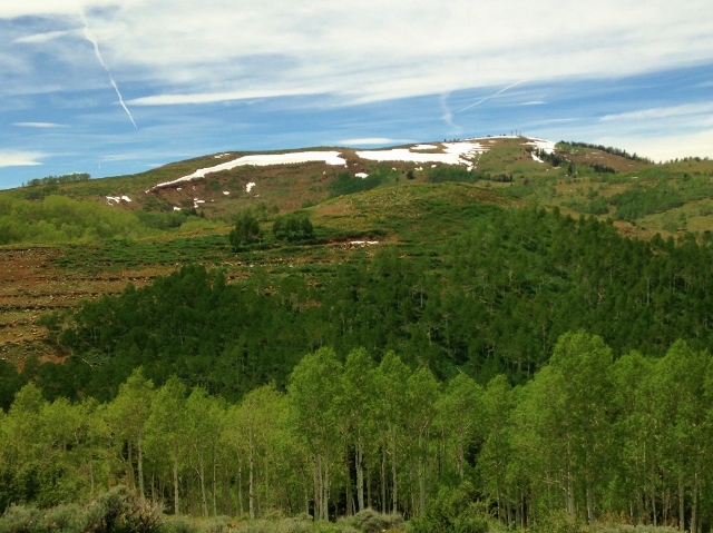
Near familiar Sunset Peak I lost another half hour taking a wrong turn, but from there my pace increased and I enjoyed the cool morning at 9,000 feet. It was just me and the deer. At times it really felt like I was on top of the world. The ridges would often be above the tree line with amazing views in all directions. But with my loss of nearly four hours, I knew I needed to make steady progress and I paid more attention to my pace than the beauty around me. I was very surprised that most of the snow fields were gone already. The road was very dusty and dry. At mile 19.5 (8:42 into my run) I found Goat Spring and happily filled my bottles and drank deeply.
At mile 20.4 I reached road 096, the Paiute ATV route that I took last year down to Richfield. It was now 7:45 a.m. I realized that I still had about 38 more to go. Surly I could finish before sundown. But all the miles yesterday had caught up to me and including stops, I was only averaging 20-minute miles. I stopped for breakfast, chowed down a wonderful burrito, and found renewed energy. I also took time to clean all the dust out of my shoes, socks, and feet. I would do this two more times later on.
This year, the bugs were annoying. As long as I kept moving, they didn’t bother me. But other bugs, millions of cicadas, made a deafening buzz all day, like your ears are ringing loudly. My headphones with music couldn’t even drown them out. They were worst as I ran by trees but above 9,300 feet they didn’t go, so I had some relief at times with a little silence.
At mile 27.3 I took a side trip to Solitude Spring, but it was dry. This was not good because I was nearly out of water. The next spring, Indian Spring was still five milea ahead. Soon, a long string of ATVers came toward me and I flagged down the leader. They kindly gave me two ice-cold water bottles from their cooler. I drank one down quickly and used the other to top off my bottles and give me another container.
As I ran on, I considered how far behind schedule I was and decided if another ATV came by with a spare seat that I would hitch a ride to save some time. But all the ATVs I saw came from the north, returning. At mile 32.5 I took another side trip to visit Indian Spring. Thankfully that spring flowing and I filled up as much as possible. I was now 13 hours into my run, at mile 33. It was 11:45 a.m. I still had about 25 miles more.
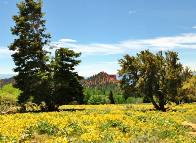
I was disappointed that I missed the flower explosions of daisies by a week or two. The beautiful yellow flowers had now shriveled up for the year. But there were many other wild flowers around. Deer would startle me at times bounding away after I startled them.
The climb up to Jacks Peak, to 9,600 feet, was very hard and slow. I was exhausted and not eating enough. But I knew that the miles ahead would now be mostly downhill. Snow fields appeared and I refreshed my bottles with wonderful slush.
At mile 43.6 at the 16:18 mark, about 3 p.m., I reached my last water stop, Robins Lake in Robins Valley at 8,957 feet. I first finished off all my water and then looked at the lake. It looked like nasty water. I saw cow and horse poop floating in places and lots of sediment flowing everywhere. I had no water filter with me or iodine pills. Yes, I could bail out at this point and go down into be blazing heat, but even so, would still need water. So I did my best to fill up all my bottles and drank an entire one. It tasted fine, but I hoped that I wouldn’t be visiting the doctor in another week.
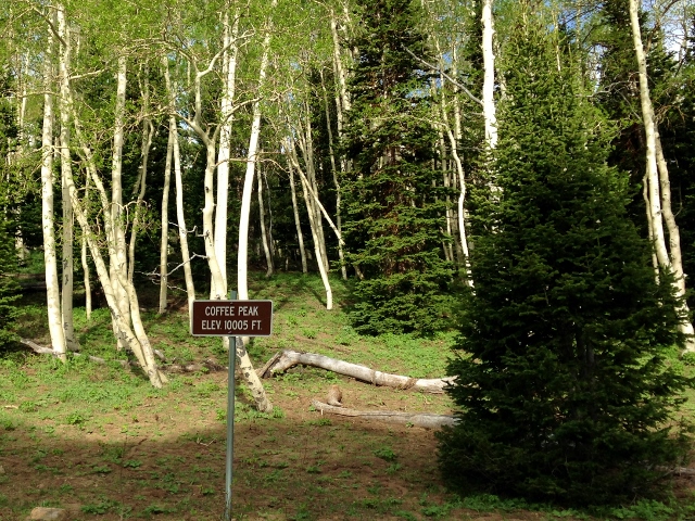
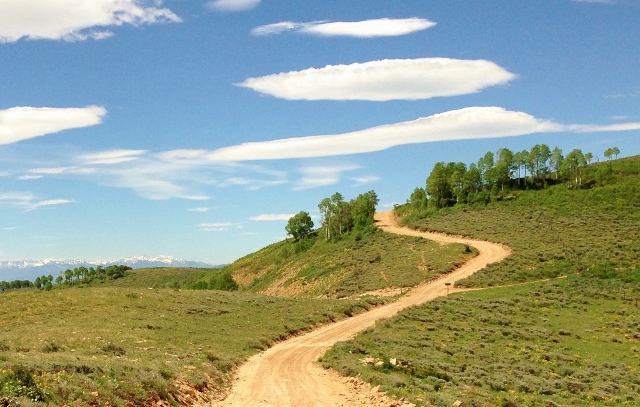
I knew that I had about 15 more miles to go and pushed up the last long climb out of that valley back on the ridge top. Road 096 ended at mile 47 near Coffee Peak. This was the trailhead for the Scipio Pass Trail and marked well. But unlike last year, there was no evidence of use or any maintenance at all. It was slow going but generally it stayed close to the top of the range’s ridge spine as it would slowly descend with many ups and downs toward Scipio.
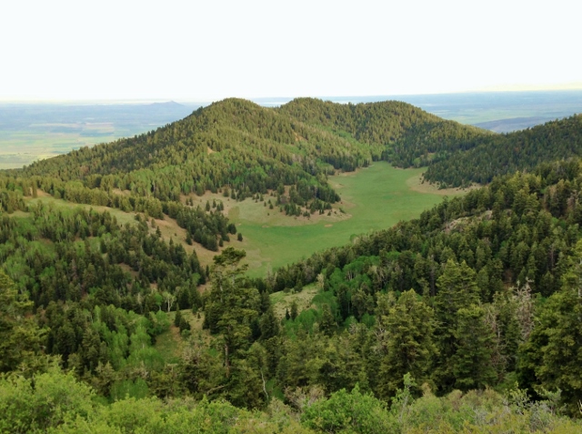
At mile 50.6 I made my next blunder. I didn’t notice that the trail split because there were no longer helpful signs. I went to the left looking down at gorgeous Indian Ranch below me, a massive flat green grassing area in a valley. The trail was pretty good, always staying at about 8,800 feet, but things seemed unfamiliar from last year when I went in the opposite direction. I continued. After another 1.7 miles on that trail, I could look down ahead and see the town of Holden to the west. Panic went through me because I knew I was far off track on the wrong ridge. I was heading down a ridge toward Holden. I looked far to the northeast and could see the ridge I should be on. I was so mad at myself. (I never considered bailing out and getting to Holden. I should have.) I had to backtrack and find out where I went wrong. There is nothing like panic to make you run fast. It is amazing because I didn’t feel pain or fatigue, the panic adrenaline sent me running like crazy. It was 6:45 p.m. at mile 52. I now knew that it would be totally impossible to finish before dark. I would also need to very carefully ration the rest of my water, only drinking a little when my mouth became very dry. Thankfully I still felt well hydrated (I had been retaining water) and my body has been trained to handle running on very little fluid.
Back on the right trail I pushed ahead as fast as I could on the ridge with many climbs along the way. I was greatly slowed because miles of the ridge had been destroyed by a fire since I had been there last year. The ash was nasty and the burnt tree limbs were totally stiff and would scratch me if I bushed up against them. The trail was pretty distinct. Darkness came at about mile 57 and I was still up around 8,800 feet with at least nine miles to go. I tried to call my wife but still couldn’t get a good signal.
As I reached another high bump on the ridge, the trail in the ash started heading down to my left to the burnt valley I had been in the morning before. I followed it for a little while, but knew this would lead me off the ridge into uncertain territory. (The trail was the relocated Scipio Pass Trail, the sign burnt away. If I would have continue on it, I probably would have reached my car in just 2 hours.) But I pushed on ahead on the ridge, now descending and climbing again over every high bump. At probably 11 p.m. I reached familiar Noon Rock Peak. I was home free! (So I thought). I knew there was a good trail ahead all the way down toward the Scipio lights blazing ahead.
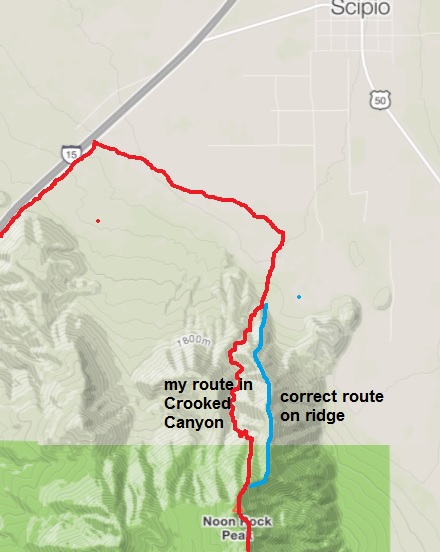
It was so dark and so easy to get turned around. I relied on my memory from last year but my sense of direction went haywire. My GPS watch batteries were dead so I had no sense of distance either. I descended down the wrong direction and soon the town lights disappeared. I knew that was wrong because I should be on the main ridge with the lights always in view. But the way ahead seemed easy. I turned back at one point, but the uphill was too hard at this point. I would continue on and take my chances. Soon I found myself in a narrow gorge and travel was slow because of the brush. I could see I-15 lights ahead and that puzzled me. I realized that I was semi-lost again. I knew generally where I was and the direction to get out, but I had no idea what lay ahead. (When I returned home, I discovered that I had veered off the ridge and had descended into Crooked Canyon, another appropriate ominous name.) I had a cell signal and left a message on my wife’s phone that I wasn’t sure where I was, but would head down toward I-15 and a gas station in view. I also mentioned that I was totally out of water. It was getting close to midnight and my last water fill-up was nearly nine hours earlier. I was very thirsty but still didn’t feel dehydrated. The air temperature was cool and I wasn’t sweating much, but breathing hard from all the work. The winding, rugged canyon kept descending. It wasn’t steep and dangerous, but I became scratched up all over going through scrub oak at times. I did take several detours around spill offs. As I got lower, the gorge turned into a nicer wash for awhile but then went back into a nasty narrow canyon. I just couldn’t understand why I kept going down instead of out toward the lights. It was very frustrating and slow. I saw an empty beer can, the first sign of humans, and expressed joy.
Finally, a new cattle fence arrived and I knew I was almost out. About 15 minutes later I spilled out into the valley, ironically within feet of the bottom of the ridge trail that would have saved me an hour. I left another message to my wife that I got out fine. I made the decision to press ahead to my car instead of going three miles in the town. It was now about 1:00 a.m.
The next couple miles to the frontage road involved hopping over many fences and crossing through wheat fields. One of the barbed wire fences nicked my knee. Later I discovered that I had a cool dribble of blood all down my leg. At one point I found myself with two horses in their large area. I searched for their water trough but didn’t want to wander all around at that point. I was so thirsty that I would have drank from it. I reached an unlocked shed and searched inside for water bottles, but there were none. Finally I reached the frontage road and turned up it to climb the remaining three miles to Scipio Pass. I was exhausted, fighting sleep deprivation, only four hours of sleep for the past 68 hours. Bad dehydration was now felt, but I was still moving. I’ve felt worse during certain 100-milers. I could have easily flagged down a car on I-15 if things got serious, but I pushed ahead on a familiar death march. Along the way to amuse me, I kept shining my light to the side of the road, hoping to find a filled water bottle. I didn’t find one, but the trash I saw was amazing. I kept focused by thinking about the water jug in my car.
Finally, around 3:00 a.m. I reached my car, fumbled quickly to get my key, jumped inside and started chugging the jug of wonderful water and a bottle of coke. In about 20 minutes I started to feel human again. It is pretty amazing that I covered those last rough miles in about 12 hours on only about 64 ounces of water in my bottles and belly. All my training makes that possible. I also had not eaten much during the past six hours. It was too hard to swallow when rationing water.
I made it! It certainly was one of the toughest adventure runs I had ever done. I hadn’t planned it that way, but I overcame many mishaps and reached the finish. Over the two days I traveled about 109 miles and climbed about than 15,000 feet. Within an hour, I was fast asleep in my car at the trailhead.
With all my wilderness running, I still learned a few good lessons. Next time for a run like this I will bring a good GPS with maps. That would have saved me many hours. Also, I should print out some topo maps. Taking pictures of them with my phone isn’t enough. They are hard to read, especially without reading glasses too. Plan better for water stops. Doing this run in the opposite direction wasn’t thought through enough because of the long slow stretch at the end without any water sources along the way. I was never worried about my safety, knowing when to bail out, but I was frustrated by the slowness and that I didn’t finish when I hoped.
Will I do this one again? Well, now I really know the correct trails to go on and wouldn’t experience those long delays, but I would stick to north to south, which I could do in many hours shorter. I also would do it a few weeks earlier when there are plenty of snow fields along the way to use for water. A little mud along the way is much better than miles of dust.
My recovery was typical, feeling like I had finished a 100-miler. Two days later I bounced back, didn’t have any muscle soreness, but my mouth would dry up fast and I drank more than usual. Also as typical after very long warm 100s, I felt very heat and light sensitive. Walking in the heat outside sapped my energy in just a few minutes. That usually goes away in a couple more days. I weighed myself a couple days later after being fully hydrated. I had lost about six pounds because of all the fat-burning during the last 12 hours of the run.
You should look into the avenza app. You can create kmls from google earth and export them into the app. Then if your phone has GPS you can refer to app during the run to see where you need to be, and it will show where you are in relation to the trail.