

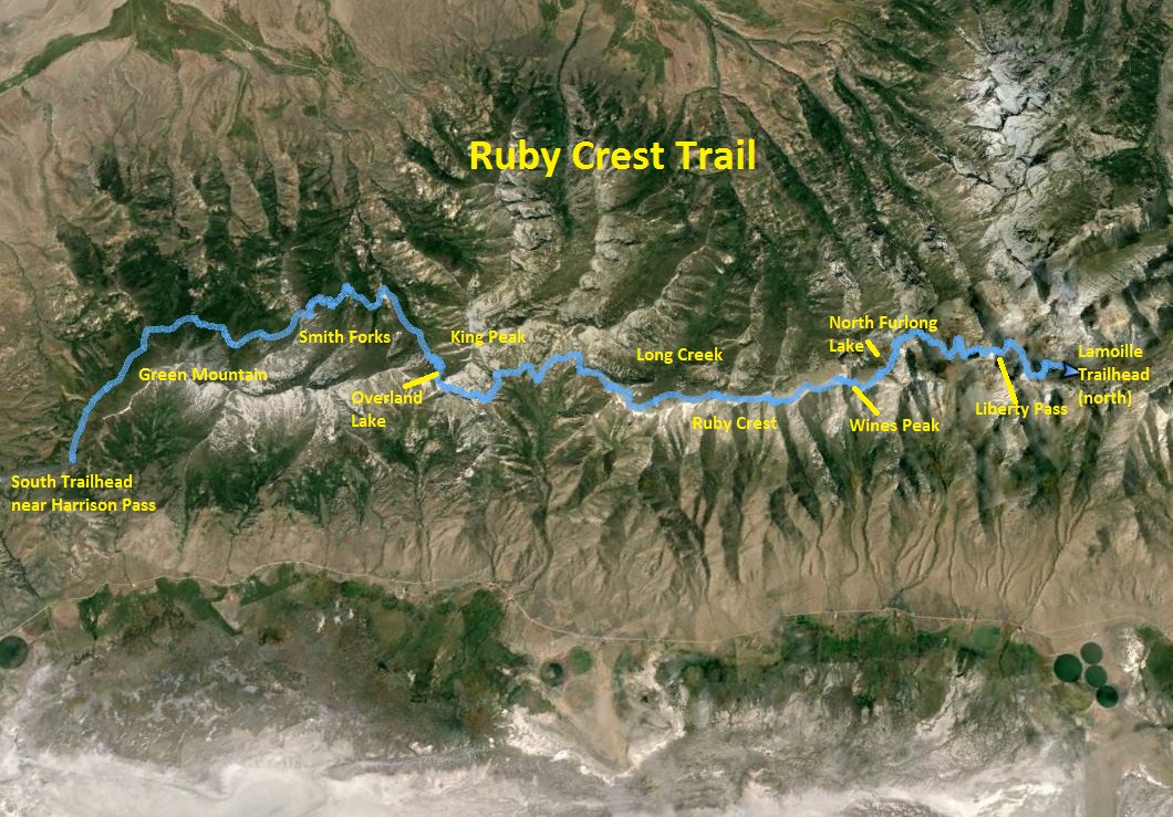
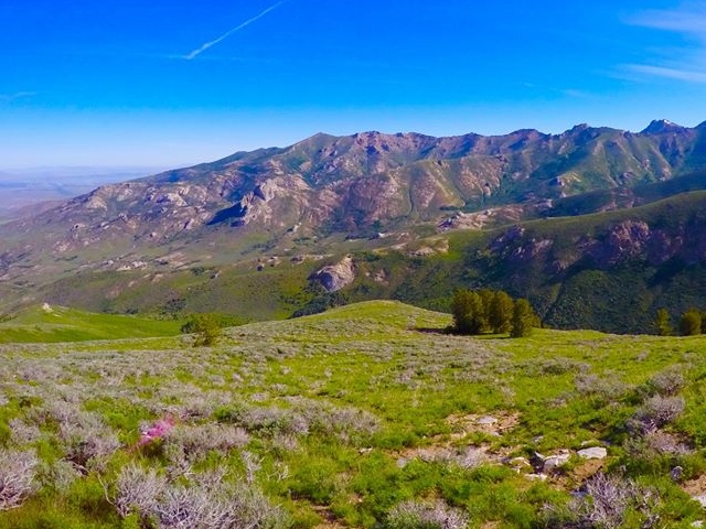
The Ruby Mountains are a range 80 miles long in Nevada above the small cities of Wells and Elko. They can be seen prominently from I-80 and usually are snow-covered late into the summer. As I’ve driven by, I’ve wondered about this range rising above the desert floor and whether or not there were any good trails up there. The range was named after garnets found by explorers. Some of the valleys were formed by glaciers.
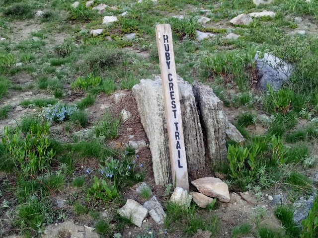
When a Facebook friend recently went to run the mountains I discovered the existence of the Ruby Crest National Recreation Trail, most of which runs through the Ruby Mountains Wilderness area between 8,000 and 11,000 feet elevation. Much of the trail was constructed by the CCC, probably in the 1950s. Recorded distances for the trail vary. A sign at the northern Lamoille trailhead states that the trail is 43 miles long, but according to my GPS watches, and considering not cutting switchbacks, trailhead to trailhead is about 33.7 miles. If you use the shorter pack trail alternative on the north end, the distance is about 33.3 miles.
Here is a handy chart of distances, north to south:
| Lamoille trailhead | 0 | 8,790 |
| Junction, Lamoille Lake | 1.6 | 9,748 |
| Liberty Pass | 2.7 | 10,428 |
| Liberty Lake | 4.4 | 10,050 |
| Kleckner Creek | 4.8 | 9,600 |
| North Furlong Lake Jct | 6.8 | 9,890 |
| Wines Peak | 8.2 | 10,900 |
| Mahogany Creek | 9.2 | 10,404 |
| Long Canyon | 13.1 | 9,836 |
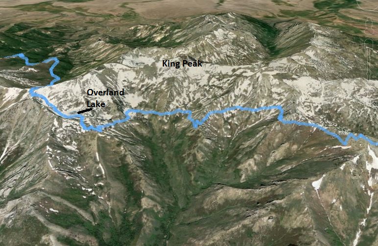
| Overland Lake | 18.8 | 9,468 |
| North Fork Trail | 21.6 | 8,443 |
| Middle Fork | 23.3 | 7,968 |
| South Fork | 24.6 | 7,932 |
| Top of ridge | 26.1 | 9,350 |
| Gilbert Creek | 29.1 | 8,455 |
| Double track road | 30.3 | 8,491 |
| South trailhead | 33.3 | 7,990 |
To me, there are five key distinctive sections of the trail. From north to south:
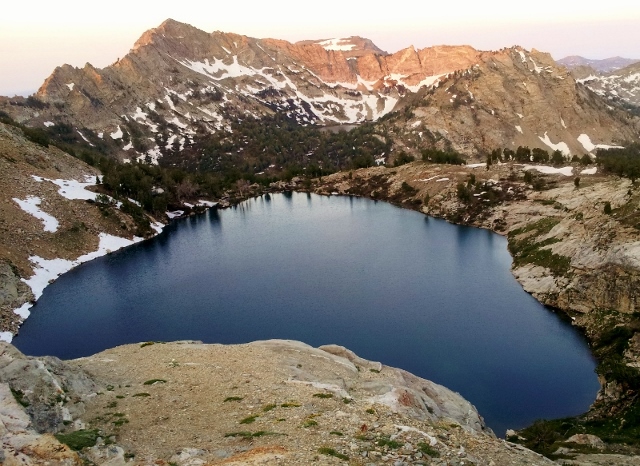
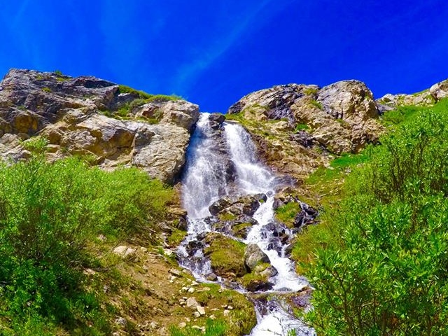
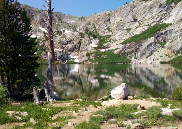
- Lake Region. This seven-mile section passes impressive high mountain lakes, Dollar, Lamoille, Liberty, Favre, and North Furlong.
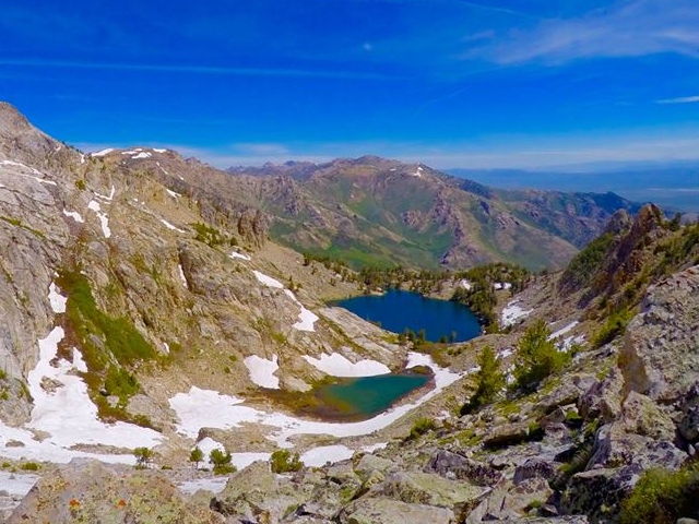
- Ruby Crest. The trail climbs above the tree line and for another seven miles climbs over high passes including Wines Peak and around ridges of other unnamed peaks. It also visits the tops of Mahogany and Long Canyons. This section has no creeks for water. Mountain goats are often seen up there.
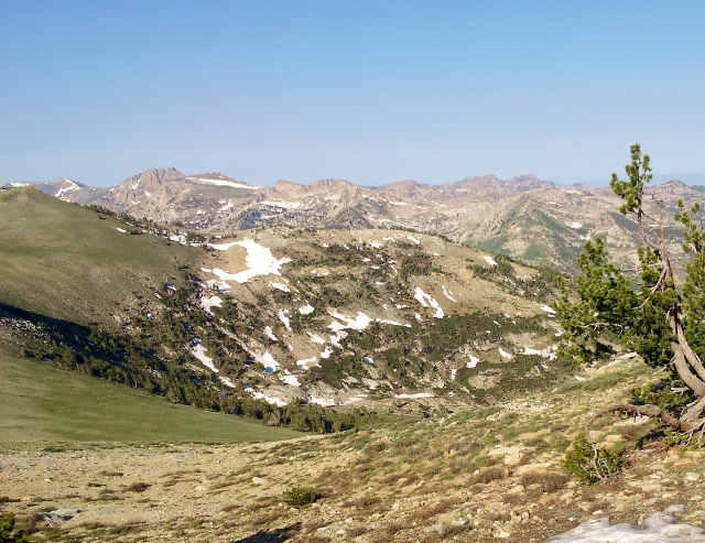
- King Peak drainage. For about five miles the trail descends and makes a traverse in and out of all the east side King Peak drainages with its various creeks. This section presents one of the “flatter” or rolling sections of the trail that can be run pretty fast. It then climbs up a valley visiting beautiful Overland Lake.
- Smith Creek Forks. The trail climbs up and over one of King Peak’s ridges and does a massive descent into Smith Creek drainage. For five miles it visits the three forks, north, middle, and south, and then makes a massive climb up and over a Green Mountain ridge.
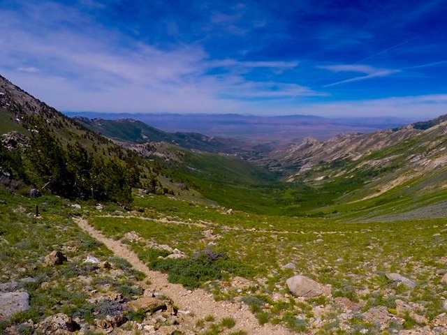
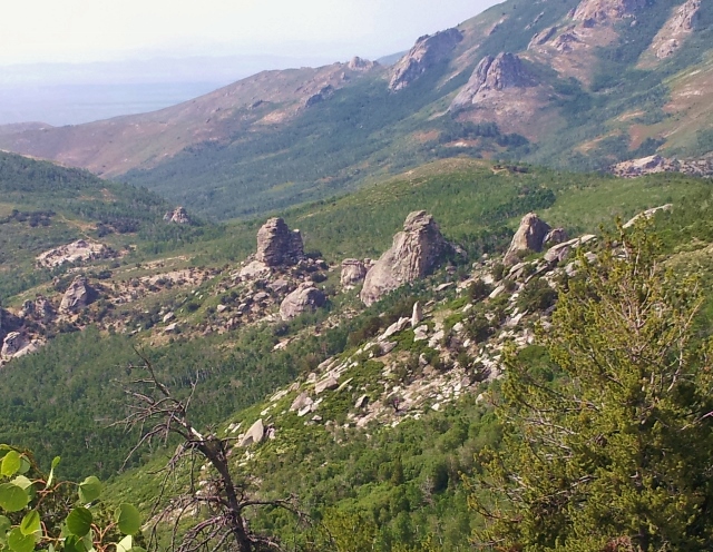
- Green Mountain drainage. For the last seven miles, the trail finally traverses around Green Mountain crossing over creeks, past interesting rock formations and going through lower altitude meadows.
I believe the most scenic sections by far are the first three. Water runs reliably year-round on the trail. In late summer there is a ten-mile dry section between reliable water as it climbs and run on the Ruby Crest. In early summer there are many snow patches and many more creeks with runoff with no long dry sections. In the early season the longest dry section is the last five miles on the south.
I decided that I wanted to go after two “firsts.” As far as I could tell, the fastest known time (FKT) for the trail in either direction was around 11:30. I wanted to beat that and thought I could break ten hours. The problem with a FKT on this trail is the confusion on the south end. The official trailhead is 2.8 miles up a 4WD from Harrison Pass. FKTs should be timed trailhead to trailhead, but most runners start from the Harrison Pass or from a campsite without recording their trailhead time. (Later I learned that in 2013 Stephen Lindsay, starting from the pass ran the trail in 10:23. It is unknown what his trailhead time was, probably around 9:45.)
Secondly, since I didn’t have anyone to help shuttle me because of this point-to-point trail, I decided to try to be the first person to run it back and forth, for a double.
The trail can of course be run in any direction, the most common is south to north because north is more conveniently closer to finish up. I chose to run it starting on the higher north side close to a campground I stayed at. The day before my run I drove over to the south end and indeed discovered that the true trailhead was marked by a sign as 2.8 miles from Harrison Pass. I decided I needed to measure and time my run trailhead to trailhead. I wanted to drop off some food and drink for my return trip. Since I didn’t have a 4WD vehicle with me, I ran up to the trailhead and cached my supplies for the next day.
I knew my run day would be very hot, about 100 degrees on the desert floor, bring running temperatures up in the 80s. I wanted to start my run as early as possible so I could reach the lower 8,000 foot turnaround as early as possible to avoid the heat. But the problem with a pre-dawn start was the lingering snow. I needed the light to find the continuing trail as it disappeared at times during miles 2-7. I decided that I would start only a half hour before daylight.
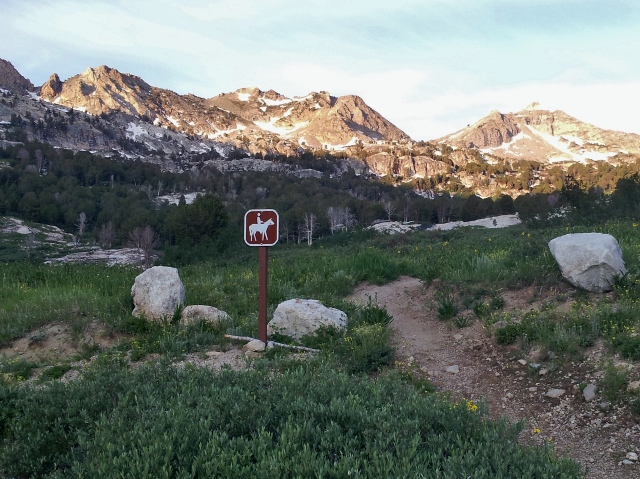
My run started at 4:13 a.m. At the Lamoille trailhead, the Ruby Crest trail has two branches. One is a shorter, but rougher pack trail. I used the pack trail and had no trouble navigating up to Lamoille Lake. But after that, things got confusing as the trail disappeared at times under the snow as it climbed to Liberty Pass. I had to pull out my map a couple times to help me head in the right direction. Each time I figured things out and continued without backtracking arriving at Liberty Pass (mile 2.7, 10,428 feet) at 1:05 after climbing nearly 2,000 feet.
The sun started to shine on the mountain peaks and I had beautiful views of the lakes below, Liberty Lake and Favre Lake. After seeing some campers back at Lamoille Lake, I now saw no evidence that there was anyone further up the trail. I was now on my own. This would be a very remote run during this early summer season and I expected to see no one along the way. I took some precautions, knowing bail-out points to get down. My cell phone had service near the highest points which brought some comfort.
My progress slowed on the way to North Furlong Lake. There were many huge downed trees crossing the trail and more snow patches to get through. By the time I reached the North Furlong Lake trail (mile 6.8), at 2:40, I was well behind my projected schedule. As I climbed up out of the snowy forest, I lost the trail altogether as I left the tree line. Was the trail to the left or the right? I paused and tried to figure it out but just climbed higher expecting to eventually find it and I did.
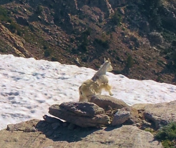
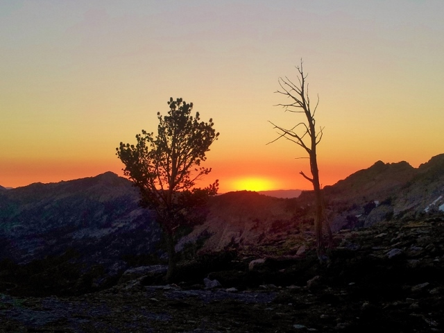
The views were spectacular as I now was truly running on the Ruby Crest making my way up to Wines Peak. A mountain goat ran by and I quietly followed it over the ridge and took a picture. I also found cell signal and texted a message to my wife that all was well.
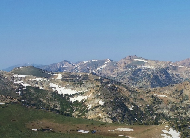
I reached the top of Wines Peak (mile 8.2, 10,920 feet) at 3:30 and took in all the views around me. But all my stops, navigation challenges, sight-seeing, and phone checking had greatly slowed me down. I had been running for three and a half hours but had only covered 8.2 miles so far. I decided that I would put the camera away and start concentrating on my pace, trying for the fastest known time. I would have time on my return trip for more photo taking.
I picked up my pace greatly as I ran down to the top of Mahogany Creek and then up and around other peaks on the crest. With each turn around a ridge more amazing views were presented. I stopped several times to refill my water bottles with snow and really enjoyed drinking the cold slush.
Leaving the ridge, I descended down and started traversing around a massive valley below King Peak above. I expected to quickly ascend again to Overland Lake, but the trail continued to traverse, rolling up and down, letting me to run full speed at times. My expected distance was wrong and at times I wondered if I was still going the right way and slowed down. After about four miles of crossing creeks and winding in and out of side canyons, I finally climbed up to Overland Lake (mile 18.8) at 6:00.
The beautiful lake was a great stopping point for my first long stop. I feasted on a burrito, refilled my pockets with gels and candy, and took a needed rest. Even with my much improved pace, I was now at six hours in just over the half-way mark. A sub-10-hour first trip would need faster attention.
I next climbed back onto snow obscured trails but I knew that my destination was the ridge saddle high above. I did some boulder hopping and snow field climbing but quickly arrived at the top (10,169). I pushed the pace descending on the switchbacks and dropped 2,000 feet quickly into the North Smith Fork Canyon. The views were less impressive on these western slopes.
I had hoped to really run fast through the Smith Creek area but was greatly disappointed to discover that the trail was very overgrown as I reached the tree line. The young aspens and other bushes extended their branches across the trail. The trail was easy to follow but I had to continually push aside branches. As I tried to run fast, my shins started to be cut up from all the brush. Also the heat of the late morning at this lower altitude affected me. In the overgrown sections, I felt humidity put out by the greenery. It became oppressive without a breeze and slowed me down to a walk.
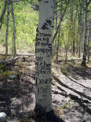
I hoped the trail overgrowth would improve, but it did not as I visited both the middle and south forks, each time descending below 8,000 feet into the heat. Along the way I viewed carvings in the mature aspen trees from Antonio Hidalgo, a sheepherder from Peru who spent time there in 1982-83.
Next up was a massive climb up to a ridge line of Green Mountain. Most of the trail thus far had used kind switchbacks to help, but this section had fewer of them as I climbed up and up above the valley below. I was glad to feel cool breezes again and soon arrived at the top (9,350) at mile 26.1. It had been a slow and very tough 8:50 marathon. I knew that breaking 10 hours was impossible but I still hoped to break 11 hours so I pushed hard down the other side of the ridge into the Green Mountain drainage.
After a couple more miles, I came across my first humans, two women backpackers filling their bottles at the first creek I had seen since South Smith Creek fork. I was out of water in the hot afternoon and glad to see the creek. I stopped for a few minutes to chat. They were surprised to hear that I had run from the north trailhead, starting at dawn. I blew their minds when I told them that I would be also running back and hoped to finish by the next dawn. I let them know that this was the last water until the South Fork and advised them that it would be the best area to camp. They made mention of suffering from mosquitos ahead. They had used mud to cover their exposed skin to avoid the bites.
The warm afternoon was taking its toll. I had been drinking good amounts but still I could tell that I was badly dehydrated. After another climb over a ridge I came to the only section of the trail that isn’t single-track, a double track rough 4WD road that would take me three miles to the south trailhead. I pushed the pace and arrived there in a respectable 10:42:03. I know that I could do it much faster if I removed all the delays and ran on a cooler day. I suspect I could probably come close to breaking nine hours with good knowledge of the trail now. I had climbed about 10,000 feet along the way so far.
At the trailhead, I now was in no hurry. But a swarm of vicious mosquitos soon found me. I quickly got out my repellant and that seemed to work. I found my cache of additional burritos and Ensures. It was too hot to spend much time there and I looked forward to returning to cool shade and streams. There were no thoughts of quitting. I had no easy way out and was ready to attack the trail again to accomplish the double.
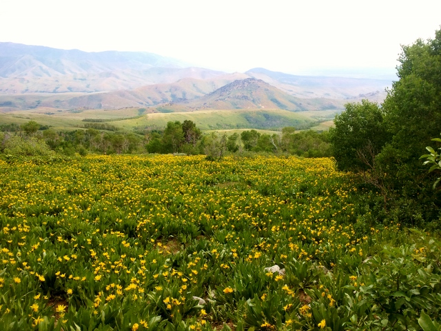
On my way again, I had no concerns about my pace so I slowed and averaged 20-minute pace for a while going both up and down. My climbing strength was still very good. I went through some amazing fields of wildflowers and just appreciated more of the beauty around me. But I went through swarms of mosquitos and after sweating hard, the repellant wore off in just 30 minutes. It gave me more motivation to run faster. I was left with about fifteen bites on my arms.
A couple hours later when I arrived at the South Fork of Smith Creek (mile 42), I expected to see the backpackers, but hearing their voices, I could tell they set up camp away from the trail, upstream in a secluded spot. I decided not to disturb them and continued on. Thankfully clouds had moved in during the late afternoon which made going through the overgrowth area more bearable.
When I arrived back at the middle fork (mile 43.3) at 6:50 p.m., I made a long stop in the shade by the creek to retape my feet. There had been a couple creek crossings that involved mud and wet feet. I washed my feet and retaped the usual spots to avoid blisters. I ate and drank well and after 30 minutes of rest, I was on my way again.
I plowed my way up the overgrown aspen section and was relieved to get above the tree line as the sun was setting. Dusk arrived by the time I returned to the top of the ridge above Overland Lake. I made good time working my way down the switch backs flowing with runoff water. I arrived back at Overland Lake (mile 47.8) at 17:18 (9:31 p.m.). The next traverse section in and out of the drainages seemed to take forever. I thought I was finished with it, but around the next corner was yet another valley to get around. Another big climb and descent brought me back to the top of Long Creek Canyon (mile 53.5) at midnight.
I loved running on top of the Ruby Crest in the middle of the night. I could see small town lights down to the west and ranch lights to the east. It was so peaceful. A setting half-moon lighted my way. I considered that I was probably the first person to run this crest during the middle of the night. I texted my wife who traveled to Las Vegas that day and she returned my text giving me comfort that she was fine and knew I was fine. But I was drowsy and thirsty. I ran out of water but kept using passing snow fields. I had overcome my dehydration from the afternoon and I was now left with a dry mouth making it hard to eat.
As I was running toward the next pass to get up and over, I sang loudly to my music. There was no one for miles, with no one to hear my beautiful melodies. So I thought. Soon on the next slope in the distance I heard a pack of coyotes howling at me, perhaps joining in on the music. More likely, they were music critics and I disturbed their hunting. The climbs were really getting to me. I know I wasn’t eating enough and I had no appetite. My energy was getting low and my stomach was starting to rebel at this high altitude. Eventually I just needed to stop, rest, and lie down on the trail for a few minutes. Then I would jump up and continue. I took another two of these quick rests.
I arrived back to the top of Wines Peak (mile 58.4) at 22:17 (2:30 a.m.). I had originally hoped to be finished by this time and then going to my campground to sleep. I still had 8.2 miles left with one more huge climb. The finish now seemed to be close.
The snow and downed trees were a bother again near North Furlong Lake, but even with the dark I made pretty good time and quickly figured out the right way to go. As I was running along, I startled a big critter. It was a beaver and it ran very quickly ahead of me on the trail, hopping over rocks with good technique.
Dawn arrived and I turned off my light as I was climbing up to Liberty Pass. I arrived there (mile 63.9) at 24:47 (5:00 a.m.). On the other side, I again saw humans, some hikers and campers. At Lamoille Lake as I crossed the stream, I startled two dogs guarding their camp and aroused a sleepy camper.
The finish was now in sight and I pushed the pace running down the pack trail. Checking my watch I wanted to make sure I finished in under 25 hours and in under 15 hours for my trip back. I stumbled into the parking lot at the trailhead and stopped my watch. 25:38:07 for my double, and 14:56:03 for my return trip.
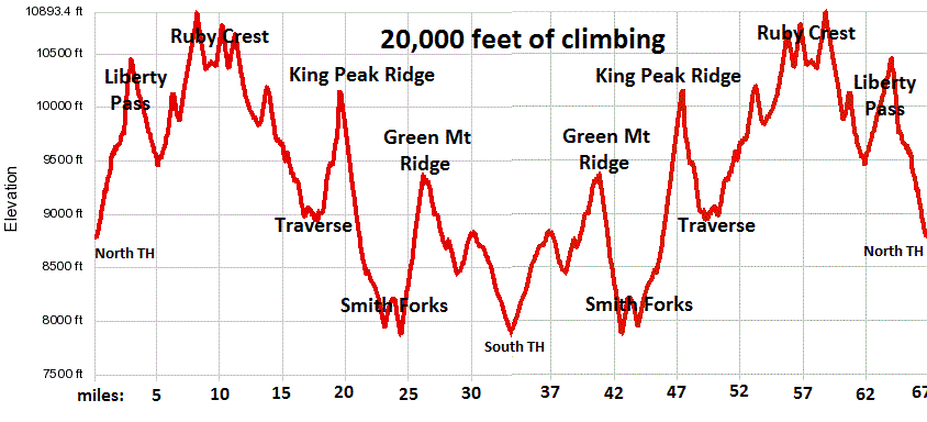
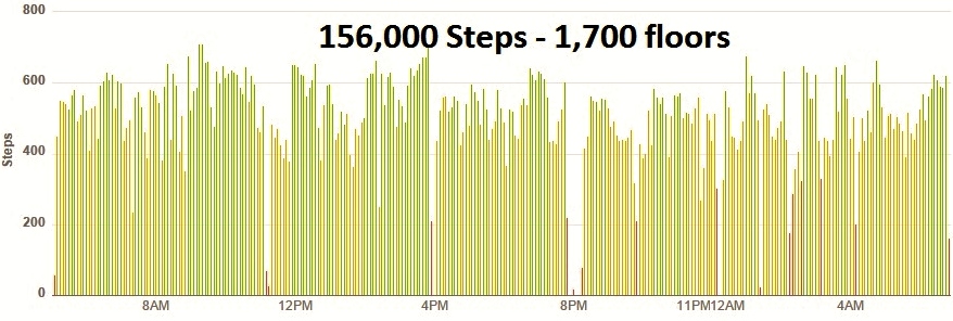
Wow! What an adventure. I did it! All that climbing! It totaled about 20,000 feet of climbing in 66.6 miles. I went back to my campground, washed up well, and rested in my tent for an hour before starting the four-hour trip back home.
That turned out to be one of my finest solo adventure runs ever. The Ruby Mountains are an amazing place. I’m sure I will return and run the trail much faster.
Here are my split times. I hope that someone will beat these times.
| Lamoille trailhead | 0 | 4:13 AM | 0:00:00 |
| Lamoille Lake | 1.6 | 4:43 AM | 0:30:00 |
| Liberty Pass | 2.7 | 5:18 AM | 1:05:00 |
| Liberty Lake | 4.4 | 5:33 AM | 1:20:00 |
| Kleckner Creek | 4.8 | 5:53 AM | 1:40:00 |
| North Furlong Lake Jct | 6.8 | 6:53 AM | 2:40:00 |
| Wines Peak | 8.2 | 7:43 AM | 3:30:00 |
| Mahogany Creek | 9.2 | 7:58 AM | 3:45:00 |
| Long Canyon | 13.1 | 8:33 AM | 4:20:00 |
| Overland Lake | 18.8 | 10:13 AM | 6:00:00 |
| North Fork Trail | 21.6 | 11:03 AM | 6:50:00 |
| Middle Fork | 23.3 | 11:43 AM | 7:30:00 |
| South Fork | 24.6 | 12:13 PM | 8:00:00 |
| Top of ridge | 26.1 | 1:03 PM | 8:50:00 |
| Gilbert Creek | 29.1 | 1:33 PM | 9:20:00 |
| Double track road | 30.3 | 2:03 PM | 9:50:00 |
| South trailhead | 33.3 | 2:56 PM | 10:43:00 |
| Double track road | 36.3 | 3:41 PM | 11:28:00 |
| Gilbert Creek | 37.5 | 4:31 PM | 12:18:00 |
| Top of ridge | 40.5 | 5:31 PM | 13:18:00 |
| South Fork | 42 | 6:16 PM | 14:03:00 |
| Middle Fork | 43.3 | 6:51 PM | 14:38:00 |
| North Fork Trail | 45 | 7:51 PM | 15:38:00 |
| Overland Lake | 47.8 | 9:31 PM | 17:18:00 |
| Long Canyon | 53.5 | 12:00 AM | 19:47:00 |
| Mahogany Creek | 57.4 | 2:00 AM | 21:47:00 |
| Wines Peak | 58.4 | 2:30 AM | 22:17:00 |
| North Furlong Lake Jct | 59.8 | 3:07 AM | 22:54:00 |
| Kleckner Creek | 61.8 | 4:00 AM | 23:47:00 |
| Liberty Lake | 62.2 | 4:36 AM | 24:23:00 |
| Liberty Pass | 63.9 | 5:00 AM | 24:47:00 |
| Lamoille Lake | 65 | 5:24 AM | 25:11:00 |
| Lamoille trailhead | 66.6 | 5:52 AM | 25:38:07 |
Wow – what a great run! Sounds like a beautiful mountain range. Glad all went well!
Hi there – I’m interested in running this but only from North to South and a friend is running it South to North. I was hoping you could tell me the elevation gains for each section. I see that running S – N means more gain too. Any info would be greatly appreciated! Thanks and nice run!
This description cleared up a lot of questions including the discrepancy in mileage at the South trailhead, a description of the areas without water, and a categorization of the 3 sections. Thank you for the resource!