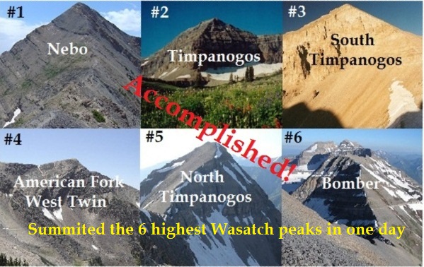
Could it be done? Once I set a goal it eats at me to complete it. The highest peaks in Utah are found in the Uinta mountain range, but the most impressive peaks that rise from the valley floor to the sky are found in the Wasatch Front. Could the top six be summited in one day? After sumiting numbers 1-3, 5-6 in one day a week ago, I was determined to do it right, all six. I decided to take work off on Friday and head up to the mountains Thursday night to get it done.
The highest peaks in Utah are found in the Uinta mountain range, but the most impressive peaks that rise from the valley floor to the sky are found in the Wasatch Front. In 2012 Jared Campbell had summited the highest three Wasatch peaks in one day. I considered if it was possible to summit the four highest Wasatch peaks in one day. I knew I could do it. If I was going to do four, why not the highest six because the other two were nearby. That was my quest for this adventure.
You can define the highest peaks in several ways. I chose to use a 300-foot prominence definition. If you have two peaks close together, there must be at least 300 feet of descent between them to count the lower peak as a ranked peak.
Kings Peak is the highest peak in Utah. I again attempted to do a Kings Peak Triple (three consecutive summits from the trailhead, 78 miles), but again I came up short. I think this is one of the mentally toughest running accomplishments that I have attempted. I just couldn’t push myself to go out again for that long third trip. But wow! I had an incredible adventure.
This time, I started earlier so both summits #1 and #2 would be accomplished in the daylight. Then, I could take my sweet time on summit #3 during the night. It was a good plan and I stayed right to my schedule.
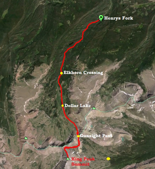
Kings Peak is the highest peak in Utah at 13,528 feet. I’ve summited it ten times in the past. In 2010 I accomplished the first double Kings Peak, trailhead to summit and back, and then did it again. I knew a triple Kings Peak was within my reach so I went to give it a try.
I arrived at the Henry Fork trailhead early Friday morning and snoozed until dawn and then got ready. About ten minutes before heading out, I noticed two young guys, probably in their 20s heading out with light day packs running. Good, I would have someone to try to catch. I wasn’t going to try to push the pace hard because I needed to save it for the other trips, but I felt really well running at 10,000 feet with all the running I have been doing recently at altitude. As I ran early, I was puzzled that I had not yet caught the two guys, but I finally did at the four-mile mark. This time I decided to be open with people I met and tell them that I was doing the run multiple times. It would be entertaining all day hearing the reactions. I reached Elk Horn crossing (mile 5.5) at 1:08.
The High Uintas are open early this year for running. It was time to get up there. I was interested in trying something new and decided to go run the Brown Duck Mountain Loop. The trailhead is north of Duchesne and Mountain Home, at Moon Lake. It was an easy drive, 2:45 from my home, all on pavement. I arrived about 11 p.m. and slept in the car. I woke up at 4 a.m. to get ready, but there was a big windstorm going through with a little rain. I had no desire to run in terrible wind, so I went back to sleep.
I ended up getting on the trail around 7 a.m. and had wonderful weather all day. The rain the previous day or night was nice because the trail was soft and not very dusty. I had previously thought about also summitting Duck Mountain, but as I approached it, I could see that it was just a pile of rocks. To get to the summit and back to the trail would be six miles of boulder hopping which would take hours. Instead, I tried to run the actual loop fairly fast, faster than my normal adventure runs. But I took plenty of time for pictures and several stops to eat. The video tells the rest of the story.
Probably the toughest 100K race in the country is held in Utah, in August each year. It is called Kat’cina Mosa 100K but its name has nothing to do with the geography. The race director has interests in the Hopi culture from Arizona, so he named the course after it. A more apt name would probably be Wasatch Back 100K. The course runs a huge loop behind the Wasatch Mountains that rise above Provo and Springvale. Nearly half of the course shares the same course as Squaw Peak 50, but in the opposite direction. Kat’cina Mosa runs clockwise and includes about 17,000 feet of climbing along the way over its 62 miles.
For the past ten weeks, I have been doing very long weekend runs instead of daily workouts. I have accomplished eight runs of 50 miles or more during those ten weeks. By doing so many very long runs in close succession, my body is adapting and recovering very fast, getting ready for the next run. This weekend, I chose to run the Kat’cina Mosa course solo and unsupported, through the night.
After running Bryce 100 last week, I took a rest for a few days and the decided that I should to do something crazy. I went and ran the Squaw Peak 50 course unsupported because I missed it last week since it was on the same weekend as Bryce 100 this year.
I went to do one of my favorite run, Paria Canyon located halfway between Kanab and Page on the Utah/Arizona border. It is the scene of my first major backpack trip back in the mid 90s that hooked me on the outdoors. I came away from that with swollen ankles and could hardly walk for a week. I returned years later for my first long-distance “run” and also came away injured. This would be my sixth time in the canyon. End-to-end to Lees Ferry is around 42-45 miles depending on routes. This video tells much of the story:
It has been a long 15 months of injury recovery from a terrible tibia stress fracture and other associated side-effects. Finally, after all that time, I feel injury-free, able to again go on long solo adventure runs, my favorite part of running. Two weeks ago I finished the Antelope Island 100 in 23:11, taking it easy because of a lingering hamstring problem. But finally, I can run up and down hills pain free.
At times, my adventure runs are the “spur of the moment” type things. If the weather looks good, and I have the time, I’ll quickly make plans, get the OK from my wife, and take off on my own to go run in some remote place. This time, I decided to return to one of my favorite places to run — the remote back country of Capitol Reef National Park in Utah. This is a unique park, no entrance fee, and very few people in the back country. I’ve been there five times before and was ready for a nice long run. I stayed the night in Torrey and hit the trail at dawn. This video tells the story.
Utah Lake is a shallow fresh-water lake in Utah Valley. It is about 20 miles long and is about 6-10 miles wide. It covers about 25% of the massive Utah Valley located about 30 miles south of Salt Lake City. During most of the winters, it will freeze solid for several weeks. For decades people have ventured out on the ice to fish, hunt ducks, ice skate, ski skate, and explore. A few years ago I ventured out to ran across it which I have done many times. I’ve run its length, run a 50-miler on it, and have even run all the way around it. Hot springs exist in and around the lake. Most are on the northern end, in Saratoga Springs, and toward the south near Lincoln Beach. Great care must be taken by anyone who ventures out on the ice. Do NOT go out there alone.
This year the lake froze very quickly from a series of days with temperatures near zero. After a couple weeks below freezing, the ice away from shore was about six inches thick. I decided it was time to run the lake again. My story is told in this video.
The return trip turned out to be very tough. Almost immediately a stiff headwind kicked up bringing windchill way down. Despite gloves, hand warmers, and pockets, my fingers kept freezing up, toes too. Interesting little snow drifts appeared everywhere as the wind blew snow toward me. It was pretty easy keeping a straight line, because I just ran into the wind.
As I approached closer to home, for the last two miles the wind had almost completely swept the ice of all the snow. The ice was very slick and I had to be extra careful. I could more clearly look down in the clear ice and see how deep the cracks went, about six inches of thickness. The wind continued. It felt like I was in an arctic desert. Finally the shore came and the wind was less fierce. I returned home a frozen runner, but I had a great time.
I accomplished my 4th 100K+ training run in the past 22 days, for a big mileage month of 441 miles. I started at 2:00 a.m. in the little town of Cedar Fort, ran clockwise around the southern portion of the Ochirrhs. Dawn came around mile 23 on the west side of the mountains. This video tells the whole story.
I felt fine at the finish. With each of these very long runs, I can feel my mileage base being restored since my downtime from injury. This was a great run. I loved being up in the mountains and also doing fast miles on the flats.
On Black Friday I usually avoid the stores and go for a very long run. This year I chose to run around the San Pitch mountain range in Central Utah. These low mountains run for 40 miles and divide massive Juab Valley to the west and Sanpete Valley on the east. I started my run at 1:00 a.m. in the small town of Levan. My goal was to reach Gunnison, 30 miles to the south by dawn. It was 25 degrees when I started and I ran through bitter cold air near Yuba Lake. It was very tough mentally to continue. I debated turning around or hitching a ride from an occasional vehicle. But I toughed it out. As the road climbed toward Gunnison, the temperature rose back into the mid-20s and I felt much better. I stopped for a quick breakfast at the gas station, and then headed east toward the rising sun. I’ll let the video tell the rest of the story:
Will I try again? Maybe. A more runnable route through Sanpete Valley would be on dirt roads running closer to the mountains. However, that bypasses all the towns with their “aid stations.” Perhaps I may someday run the length of the valley. It is a beautiful, unique place.