Menu Close

Category: Adventure Runs

The Maze – Canyonlands – 37 miles

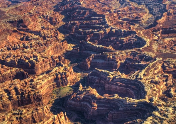
When my backpacking buddies started to discuss a destination for our annual trip, I suggested “The Maze District” of Canyonlands National Park. I knew very little about it, but did know it was very remote and we love hiking in remote areas. The Maze is one of the most remote areas in the United States and among visitors of Canyonlands, only about one percent of the visitors go there and I would bet less than that.

Last week, one of my buddies who is very experienced with off-roading went to investigate and came back with a great report. However accessing The Maze would require hours of very rugged 4wd driving or getting dropped off by boat on the Colorado River. I found a report from some ultrarunners who had run a multi-day 100+ miles there in 2013 so I believed I could access the area by running, without hours of rugged driving on longer routes.

Running end-to-end-and-back on Union Pacific Rail Trail

railtrail

The Historic Union Pacific Rail Trail is an amazing 27-mile smooth trail that starts near Echo Reservoir Dam and travels to downtown Park City, Utah. It is maintained as a state park and is 22 miles of smooth dirt and about 5 miles asphalt pavement.

In 1849, coal was discovered in Chalk Canyon, a community was established, and it eventually was named Coalville. In 1873 a rail line spur was completed from Coalville to Echo to transport coal to the transcontinental rail line. In the mid-1860s, silver was discovered in the canyons near Park City (known then as Parley’s Park City.) The first silver ore was shipped by wagon to Echo in 1871 and then taken by rail to Salt Lake City for smelting.

depot
Park City Union Pacific Depot

In 1880 the rail line spur was extended to Park City and used to transport silver ore from the mines to the rail line in Echo. In 1927 as construction began on the Echo Reservoir and Dam the rail line needed to be relocated higher. In the early 1960s, skiing took hold in Park City and in 1965 the rail line was used for “Ski Trains” that came from Salt Lake City, to Ogden, to Echo, and then to Park City. The final Ski Train ran in 1971.

train
Train on the rails near Echo Dam in 1985. I parked my car exactly here,

In 1989 the rail line was abandoned. The rails and ties were removed and the bed deeded to the State of Utah Division of Parks and Recreation.

True end-to-end Uinta Highline Trail attempt

My favorite mountain range is the Uinta Mountains in Utah. There are other ranges more beautiful, but the Uintas are so remote and challenging to run and has its own special beauty. It is one of the few ranges in North America that runs east to west. The Highline Trail (#025, #083) runs nearly the length of the mountain range. In its entirety, the Highline Trail is about 107 miles long. (mileage will vary because long sections are routes with no trail wear and the trail splits at times giving alternate routes.)

Eastern Trailhead
Eastern Trailhead

Many runners and hikers have considered the eastern trailhead of the Highline Trail to be the Leidy Peak trailhead, resulting in about 82 miles for the Highline Trail. I too considered that to be an end-to-end run when I ran it in 2010, the first to run it solo, unsupported. These runners and hikers are too quickly discarding the eastern portions of that trail to give themselves credit for an end-to-end Highline Trail run or hike. They are skipping 25.5 miles to the east that for decades has been documented as being part of the Highline Trail.

Soggy Uinta Highline Trail Run


The Uinta mountain range in Utah is one of the few ranges in North America that runs east to west. This mountain range contains all of the Utah peaks higher than 13,000 feet and it is the most remote mountain range in the state. The highest continuous established trail in the Uintas is the Highline Trail (#025) that runs the length of the mountain range. This very remote trail is one of the most remarkable trails in the nation. In its entirety, the trail is more than 100 miles long.  An 82-mile stretch from Leidy Peak on the east to Hayden Pass on the west is generally recognized as the end-to-end expanse of the trail. The rest of the trail is through mostly forest outside the wilderness area.

Previously in 2007 and 2010 I had successfully ran the Highline Trail (the first to run it solo), documented that experience, and shared my GPS data and waypoints for others to follow. Others have tried and succeeded in running the trail, but many have failed. This is a difficult, rugged experience that should not be taken lightly. The effort is very similar to running a tough 100-miler with no support. The reasons for difficulty are:

  • Thunderstorms are frequent in the high Uintas. If the trail gets wet, if becomes very slow and difficult.
  • The Uintas are known for its boulders. Much of the trail goes up and down boulder-strewn drainages between passes. Trail maintenance is performed infrequently because it is so remote and they don’t try to divert all the streams from going down the trail.
  • High Altitude. Much of the trail is above 10,000 feet.
  • Bail out. Once you get into the heart of the mountain range, any trailhead is about 15 miles away down rugged, difficult trails.
  • If you go in a group, there is a very, very high probability that at least one of you will need to bail out.
  • You need to take everything you need with you. The trailheads are too far away to go in and drop things off.
  • For long stretches the trail is faint or non-existant, only marked by occasional cairns. If you don’t know the way, you will get off trail, especially at night. That really slows things down. Following a GPS track or waypoints can help. Getting lost is pretty impossible for ultrarunners. All the trails heading down valleys eventually get to a trailhead with campers.

Pahvant Mountains Traverse


rangeFor years as I would drive south on I-15 by Fillmore, I would gaze up at a particular mountain range after passing the small town of Scipio, Utah. This range presents a peculiar flat horizon on top and I would wonder and dream of running along the top of that mountain range end to end. In 2016 I accomplished this run from Scipio to Richfield, a journey of about 58 mies. This mountain range is named the Pahvant Mountains, after the Pahvant tribe, a branch of the Ute Indians. The Pahvant Range merges into the Tushar Mountains on the south.

The Pahvants are rarely visited, mostly by ATV or horseback riders. A section of The Pauite ATV trail runs along a portion of the range. The range is about 44 miles long and 10 miles across. There are a number of peaks along the range over 10,000 feet high. In 2009, an ancient high-altitude Indian village site, named Pharo Heights, was discovered on the range top at 9,465 feet. The village was occupied between years 450-1300 A.D. It was likely a summer residence when the ridge was snow-free.

Run around Utah Lake – 80 miles

arial

Utah Lake is the largest freshwater lake in Utah.  Many rivers, streams, and creeks flow into it and there is only one outlet near my home, the Jordan River which flows to the Great Salt Lake.  Utah Lake is 12 miles across at its widest point and about 21 miles long.  This year the lake is at its 2nd lowest level in over 50 years because so much water was allowed to flow out of it during the summer for irrigation. The lake is very shallow with the maximum depth this year about 9 feet with the average less than 5 feet deep.

Each year hundreds of cyclists ride all the way around Utah Lake using a 100-mile route for a “century” ride.  There is no established trail that runs near the shores of the lake, so roads are used.  Most of the route around the lake is rural farm land with the exception of about ten miles on the east side through the Provo-Orem metropolitan area.

As far as I know, I’m the only person who has run all the way around it, with a route of about 85 miles.  I’ve run around it twice.  I looked forward to running around it again and with the low lake level, try some cross-country bushwhacking on the south end to reduce the miles.

Uinta Mountains Runs – Solitude and Beauty

sign1

The Uinta Mountain range is the highest in Utah. Much of it is protected by Wilderness area. I enjoy running up in the high Uintas because of its remoteness and rugged beauty.  Most hikers and runners who go to the Uintas, only go to the heavily traffic areas, the Mirror Lake area on the far west end, or Henry Fork in order to summit Kings Peak, the highest peak in Utah.  However, they are missing much more beautiful sections, better trails, and more interesting peaks that are usually only seen by backpackers, horseback riders, and determined fisherman.

In the Uintas, now and then, I experience one of those very special days when I have an intense connection with the trail, wilderness and nature.  This past Saturday was one of those amazing days.  The weather was perfect and beauty around me was stunning. I had the trail all to myself and the solitude was so peaceful.  I was disappointed when it ended.

Respect the Mountains

respect

As ultra and trail running becomes more popular year after year I am alarmed about a lack of respect for the mountain by many of these new trail runners. For centuries, mountains and their summits have been recognized as sacred places yet many of these young trail runners seem to think of them only as their personal playgrounds.

Some think nothing about throwing trash around the trails and purposely leaving stuff in clear sight on the high summits. Things left behind include an alarming practice of leaving “calling cards” on summits to somehow claim them and show friends that they have concurred the summit.  Others are leaving prizes, gifts, or drinks to be claimed by friends later on. Others take videos of various comical antics on summits including tossing boulders off them.  All this bothers me, but when challenged by a majority of the running community, the attitude by these few is “we can do whatever we want.”  It is just sad to see a growing disrespect for these amazing mountains by those who don’t respect the practice of “leave no trace,” or don’t value the sacred feelings others have for these mountain peaks.

The Sextuple Mount Timpanogos

Mount_Timpanogos

For more than 100 years, Mount Timpanogos (11,749 feet) has been the most popular hiking destination in Utah. Timp towers over the valley floors below by more than 7,000 feet – an impressive sight that draws hikers of all ages to its trails. A single round trip to the summit on the trail covers about 14 miles and climbs about 4,500 feet. (Compare this to about 4,460 feet elevation of climbing down into the Grand Canyon from the South Rim (Bright Angel trail) and back with about the same mileage, you just do the down section first).

When I meet people locally for the first time and they recognize my name, most of the time they ask if I am the guy who ran up and down Timp five consecutive times. I sheepishly admit that I am that person. Ten years ago I accomplished that feat. I am still the only person to accomplish a Quint Timpanogos. Three times since then, I went up with the hopes to do six, but each time I only did two or three and came home vowing that I would never try again to break it. I would tell myself that it is just too stupid and hard. Others have had their eye on this record. In 2013, Jennilyn Eaton attempted to break it, but was turned away by bad weather before her third summit. I’ve wondered if this record would ever be broken.  I was ready to try again.

Southern Oquirrh Mountains Traverse

Flat Top mountain and the Oquirrh mountains

The Oquirrh Mountains is a mountain range that runs north-south for 30 miles on the west side of Salt Lake Valley and Utah County. The mountains have been mined in gold, silver, lead and copper including one of the largest open pit copper mines, Bingham Canyon (Kenicott) mine. In 2015 I traversed the southern portion of this mountain range and had a great adventure. I decided to repeat it this year. (The Northern section includes no trespassing private property sections and is barren of snow this time of year.)

Timing for this adventure is critical because water needs. I had no desire to haul large quantities of water along the way and there are no convenient access points along the way to drop off supplies. The solution is to use snow fields, but the fields shouldn’t be deep enough to obscure the trails along the way. Thus the right time to try this would be around the first day of summer when all the snow hasn’t quite melted off. On the north side of each peak snow fields could still be found.

Pahvant Mountains Traverse

range

For years as I would drive to and from Captitol Reef National Park to run, I would gaze up at a particular mountain range after passing the small town of Scipio, Utah.  This range presents a peculiar flat horizon on top and I would wonder and dream of running along the top of that mountain range end to end, from Scipio to Richfield.  Only recently did I learn that the name of this range is the Pahvant Mountains, named after the Pahvant tribe, a branch of the Ute Indians. The Pahvant Range merges into the Tushar Mountains on the south.

The Pahvants are rarely visited, mostly by hunters, ATV riders, and horseback riders.  A section of The Pauite ATV trail runs along the southern portion of the range, connecting with the Tushar Mountains.  The range is about 44 miles long and 10 miles across. There are a number of peaks along the range over 10,000 feet high.

Run around the Simpson Mountains

horses

The Simpson Mountains are a mountain range in the remote west desert of Utah that rise nearly 4,000 feet above the desert floor.  They are about 13 miles long and ten miles across. These distinctive mountains have been viewed by travelers on the Pony Express and Overland trails since the 1860s. Native American Goshutes inhabited their canyons for centuries.  They have a long history and some of it is disturbing.

Captain Simpson
Captain James H. Simpson

The mountains are named for explorer Captain James H Simpson, topographical engineer, who was stationed at the army camp, Camp Floyd, in today’s Fairfield, Utah.  In 1858 he explored around the mountain range, and in 1859 returned in his work to lay out an overland mail route between Salt Lake City and California. For years I have wanted to explore these mountains more closely and I finally mapped out a course to run completely around them.

On Friday evening, I arrived at the northeast corner of my circuitous route, establishing my starting location at a corral above dry Government Creek. The corral was at a location once called Government Spring and had been visited by Simpson in 1858.

Porter Rockwell
Porter Rockwell

This place was also once the cattle ranch of Orrin Porter Rockwell, famed mountain man, lawman, and pioneer. He had chosen this open location in the 1850s  for a ranch because as he said, “For a cattle ranch you want a place where you can track’em out.”